

Precision data for sustainable decisions. Survey methodology that matches the environment.
Heritage & Restoration Surveying
Surveying for Heritage & Restoration Projects
Surveying for Heritage & Restoration Projects
Ageing materials, fragile structures, and undocumented modifications often make redevelopment or restoration difficult. Conventional survey methods risk damage or miss vital detail. The challenge lies in capturing every feature – from intricate façades to hidden structural elements – without disturbing the fabric of the building.
Why Accuracy Matters...
Every millimetre counts when working with listed and historic buildings. Accurate data ensures that:
Architects and conservationists can design sympathetically
preserving original character while introducing modern safety and access.
Contractors avoid structural risks
with precise data on walls, vaults, and internal spaces.
Digital preservation becomes possible
safeguarding information long after restoration is complete.
Funding and planning approvals are strengthened
with accurate, verifiable documentation.
Balancing Tradition and Technology
Balancing Tradition and Technology
By pairing traditional surveying expertise with digital innovation, we help bring heritage buildings into the future, enabling restoration that honours history while meeting modern standards of safety, access, and sustainability.
Our Services
Topographical Surveys
OS-controlled accurate, efficient and cost effective surveys for highways, civils and development. Cad and BIM-ready output.
PAS 128 utility mapping
Providing the location of underground services in 2D or 3D through qualified utility mapping surveys, using advanced GPR and Electromagnetic Location.
Measured building survey
Delivering accurate as-built information that supports design, refurbishment, planning and construction with the latest technology. Producing reliable drawings and digital models.
Laser Scanning
3D laser scanners capture millions of points per second, creating a point cloud which enables the finer details and the physical site to be viewed remotely.
Mobile mapping
For highway engineers, infrastructure managers, local authorities and contractors working on live road schemes, mobile mapping is now the standard for corridor surveys.
3D Machine control
With decades of supporting major earthworks contractors and large-scale infrastructure schemes, we provide reliable machine control across Lancashire and the wider UK.
Setting out engineers
With strong, long-standing relationships across the civil engineering and construction sector, we supply skilled professionals who keep your projects accurate, efficient and on programme.
bathymetric surveys & river surveys
Using modern technology, we capture detailed underwater and river channel information safely and efficiently – delivering reliable data you can trust.
Stockpile surveys & volumetric analysis
Whether a one-off stockpile measurement or regular monitoring, we deliver reliable, repeatable data tailored to your project using advanced technology.
Control Network Installation
Delivering robust and precise site control systems to support every stage of construction in developments, infrastructure schemes or major earthworks.
aerial & drone surveys
CAA-approved drone operations for aerial mapping, photogrammetry and volumetric analysis, providing a comprehensive view of terrain, structures and landscapes.
3D BIM Modelling
Whether you require an as-built Revit model, federated coordination model or detailed digital twin, our team delivers high quality, design-ready outputs.
survey equipment hire
We offer a vast range of surveying and engineering equipment for hire and will always try to beat a comparable quote. Discover the fleet.
monitoring
Providing reliable monitoring surveys across the UK, delivering precise data that supports risk management, compliance and informed decision making throughout a project lifecycle.
Virtual Tour 3D
An immersive experience which instantly transports your clients to your business, guiding them through your space and creating a seamless experience.
Impermeable area surveys
We deliver georeferenced impermeable area data that drainage engineers and planning consultants can work from directly.
CCTV & Drainage surveys
Acoustic & Noise Assessments
We deliver acoustic and noise assessments, supporting planning applications, discharge of conditions and Environmental Impact Assessments.
Topographical Surveys
PAS 128 utility mapping
Laser Scanning
Mobile mapping
Setting out engineers
bathymetric surveys & river surveys
Control Network Installation
aerial & drone surveys
survey equipment hire
monitoring
Impermeable area surveys
CCTV & Drainage surveys
3D Machine control
Acoustic & Noise Assessments
Stockpile surveys & volumetric analysis
3D BIM Modelling
3D BIM Modelling
Virtual Tour 3D
Why choose site surveying services
On site. On spec. On time.
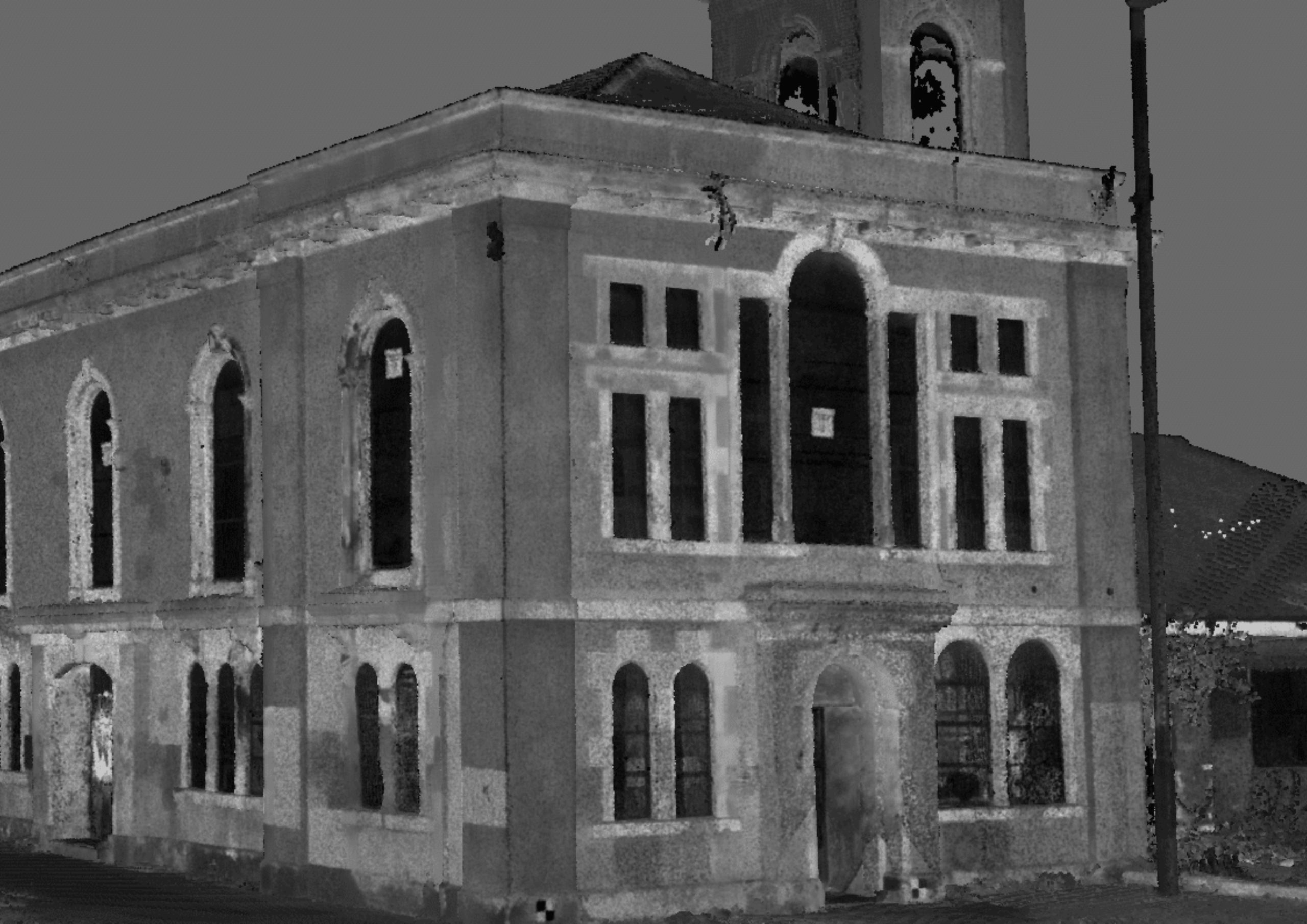
Complex geometry captured. No assumptions.
Heritage buildings are irregular, non-standard and full of the detail that tape survey misses. Laser scanning captures everything — the curvature, the moulding profile, the irregular plan — without assumptions about what should be there.
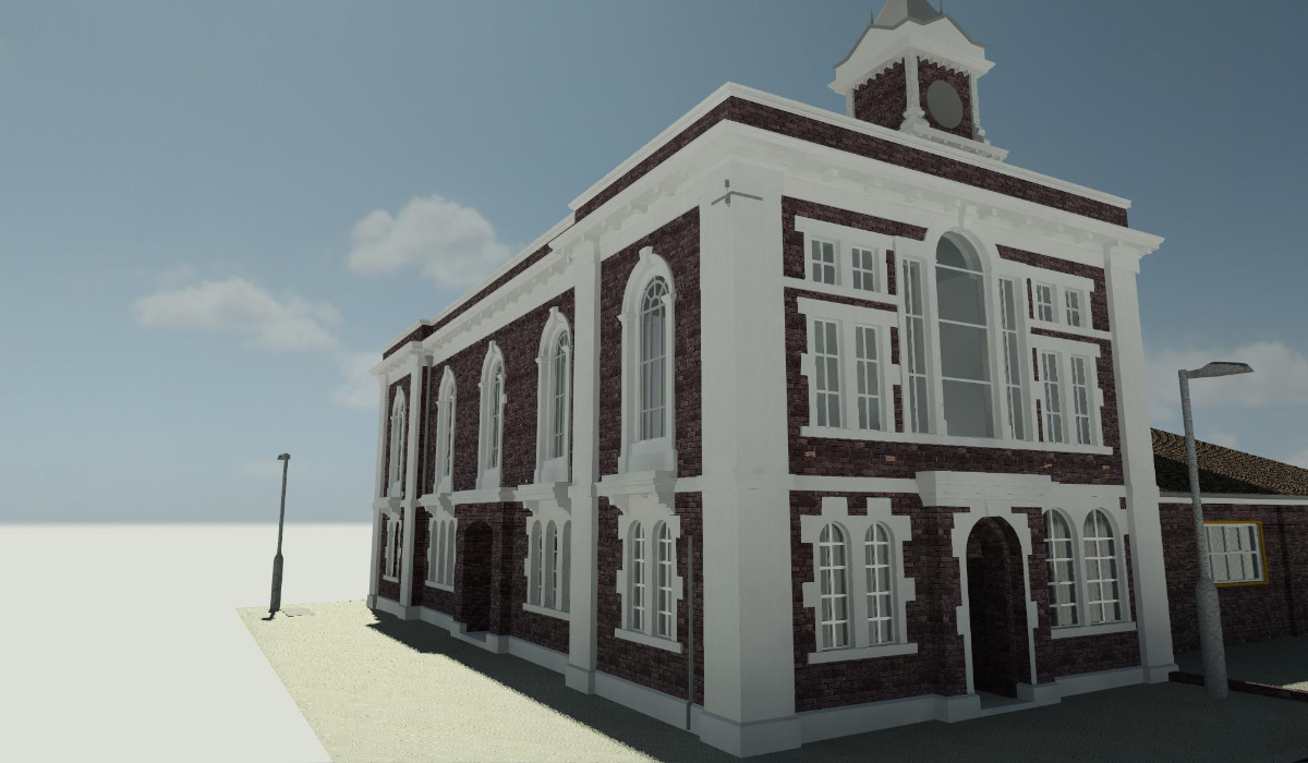
LOD 400 on heritage programmes. Demonstrated.
Middlesbrough Old Town Hall. LOD 400 BIM for a Grade II listed building. All work completed in-house. The standard that the most demanding heritage briefs require — and the evidence that we deliver it.
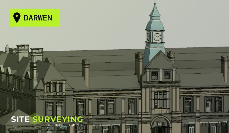
Virtual Tour 3D for public access and grant applications.
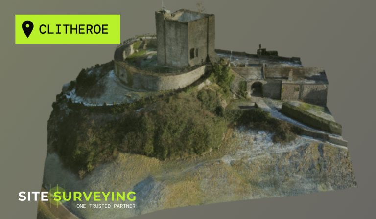
Clitheroe Castle. Darwen Market Hall. Heritage buildings made publicly accessible online — supporting engagement programmes, educational use and the grant applications that require evidence of public benefit.
Permanent datums for long-term recording programmes.
Heritage survey often spans years — baseline, condition monitoring, post-restoration record. We maintain datums so return surveys are directly comparable. The long-term data continuity that heritage programmes depend on.
Frequently Asked Questions
Frequently Asked Questions
What survey is required for a listed building consent application?
At minimum, a measured building survey of the existing building producing floor plans, elevations and sections of the parts affected by the proposed works — at the scale and detail level the conservation officer and Historic England will expect for the nature of the consent being sought. For significant alterations, a full building survey capturing all architectural detail is typically required. For scheduled monument consent, a photogrammetric survey and earthwork plan at appropriate scale may additionally be required. The scope should be agreed with the heritage consultant and conservation officer at pre-application stage — not commissioned after the application is submitted and a request for further information arrives.
Why is laser scanning particularly valuable for heritage buildings?
Heritage buildings are characterised by irregular geometry, complex historic fabric, non-standard room shapes and architectural detail that does not conform to modern standards. Tape survey can record dimensions accurately but cannot capture the spatial complexity of a heritage building — the curvature of a barrel-vaulted ceiling, the irregular plan of a medieval room, the complex moulding profile of a historic cornice. Laser scanning captures all of this complexity as raw point cloud data in a single site visit. The design team has access to every dimension they may need throughout the design process, without returning to site.
What is LOD 400 and why does it matter for heritage BIM?
LOD 400 is the Level of Development standard used in BIM that specifies fabrication-level detail — every element modelled to construction precision, with sufficient information for the building contractor to work directly from the model. On heritage projects, LOD 400 means the BIM model captures the existing building at the level of detail that allows refurbishment works to be designed and specified without ambiguity. Our Middlesbrough Old Town Hall project is a direct example — LOD 400 BIM model for a Grade II listed building, supporting a major renovation programme with nothing left to assumption.
Do you work with Historic England and conservation bodies?
Yes. We produce survey data to the standards that Historic England, local authority conservation officers and heritage bodies require — including photogrammetric surveys, measured building surveys, laser scanning and earthwork plans for scheduled monument consent, listed building consent and heritage recording programmes. Our methodology for each heritage survey is documented in full and available for review by the relevant heritage body. We are experienced in the requirements of heritage planning applications across Lancashire and the North West.
Can laser scanning be used for condition recording as well as design?
Yes — and it is one of the most valuable applications of laser scanning on heritage buildings. A high-resolution colourised point cloud of a historic building captures the condition of the fabric at a specific point in time — every crack, every area of deterioration, every surface feature — producing a complete, measurable record that can be revisited without returning to site and compared against future surveys to track condition change. For heritage buildings at risk, periodic laser scanning provides the documentary evidence of deterioration that supports grant applications and urgent works consent.
What is photogrammetric survey and when is it used in heritage?
Photogrammetric survey uses overlapping photographs processed into a dense point cloud and textured 3D model — capturing both the geometry and the visual character of a heritage surface in a single operation. It is particularly valuable for heritage facades, decorative stonework, sculptural elements and any surface where the visual texture is as important as the geometric accuracy. We combine photogrammetric survey with terrestrial laser scanning on heritage programmes where both dimensional accuracy and photorealistic surface detail are required — the scan providing the geometric framework, the photogrammetry providing the texture and visual record.
Do you survey underground heritage structures?
Yes. We have surveyed restricted underground structures including 19th-century coal transport tunnels beneath Sunderland — deploying GPS and total station traverse for control throughout the tunnel network, with checkerboard targets at regular intervals and UAV photogrammetry for interior capture. Underground heritage survey requires careful access planning, specific survey methodologies adapted for GPS-denied environments, and in some cases portable lighting for scan and photogrammetric capture. We agree the methodology for underground heritage survey with the client and heritage body before mobilisation.
Can you produce a Virtual Tour 3D of a heritage building for public access?
Yes — and this is one of the most compelling applications of Matterport Pro 3 technology for heritage. A virtual tour of a heritage building allows members of the public to experience the space without physically attending — which is particularly valuable for buildings that are normally inaccessible, for buildings awaiting restoration and for grant applications where demonstrating public benefit and access is required. Our virtual tour of Clitheroe Castle — a Scheduled Ancient Monument — is a direct example. The tour is publicly accessible online and supports the castle’s heritage engagement and educational programme.