


 Leeds
Leeds Doncaster
 Sheffield
 Bradford
 Hull
Hull Halifax
 Sunderland
 Newcastle
 Middlesborough
 Yorkshire Moors
 Teesside
 Cumbria
 Harrogate
 York
York Yorkshire Dales
 Northumberland
 Goole
Goole Carlisle
 Keswick
 Kendal
 Barrow-in-Furness
 Lancaster
 Blackpool
 Morecambe
 Southport
 Liverpool
 Wigan
Wigan Manchester
 Blackburn
 Burnley
 Forest of Bowland
 Oldham
 Chester
 Stockport
 Peak District
 Skipton
 Crewe
Crewe Rotherham
 Stoke
Stoke Driffield
Surveying Services North east
Site Surveying Services in Teesside & the Tees Valley
Teesside is one of the UK’s most significant industrial and economic areas — a cluster of major manufacturing, chemical processing, and port facilities around the Tees estuary, alongside a growing residential and commercial development sector driven by the Tees Valley Combined Authority’s ambitious regeneration agenda. From the steel and chemical heartland of Redcar and the Wilton International site to the urban regeneration of Middlesbrough and Stockton-on-Tees, and from the dramatic clifftop setting of Saltburn-by-the-Sea to the offshore energy developments transforming the wider Tees estuary, this is an area of genuine industrial scale and complexity.
Site Surveying Services delivers professional surveying across Teesside and the Tees Valley, with direct experience of working on some of the area’s most demanding industrial environments. Our teams travel regularly to the North East as part of our nationwide operations, bringing the technology, methodology, and resilience that large-scale industrial survey work in this region demands. Whether your project is at an active industrial facility, a coastal development site, a residential scheme, or a commercial property across the Tees Valley, we are equipped and ready to deliver.
Our Surveying Services in Teesside
We offer a comprehensive range of professional surveying services to clients across Teesside and the Tees Valley:
Topographic Surveys Teesside
detailed land and site surveys for planning, industrial development, and infrastructure across the Tees Valley
Measured Building Surveys Teessde
floor plans, elevations, and sections for industrial, commercial, and heritage buildings
3D Laser Scanning Teesside
high-density point cloud surveys using Trimble X7 for complex industrial facilities, large-scale structures, and challenging environments
Utility Surveys Teesside
underground service detection and mapping using GPR, CAT & Genny
Sectors We Serve in Teesside
Our Teesside project capability reflects the area’s unique industrial and development character:
Industrial & Chemical Processing Teesside
laser scanning of large-scale industrial facilities, chemical plants, and processing structures where dust, restricted access, and complex geometry demand advanced methodology
Infrastructure & Transport Teesside
surveys for roads, utilities, and public realm across the Tees Valley
Commercial & Regeneration Teesside
surveys supporting Middlesbrough and Stockton's active town centre regeneration programmes
Coastal & Environmental Teesside
surveys on and adjacent to the North Yorkshire coast and the Tees estuary's sensitive coastal environments
Residential Development Teesside
topographic and utility surveys for housing schemes across the Tees Valley's urban and coastal communities
Port & Marine Teesside
surveys for port infrastructure, marine facilities, and the Tees estuary's growing offshore energy supply chain
Surveying Case Studies & Project Highlights in Teesside
Case Studies & Project Highlights
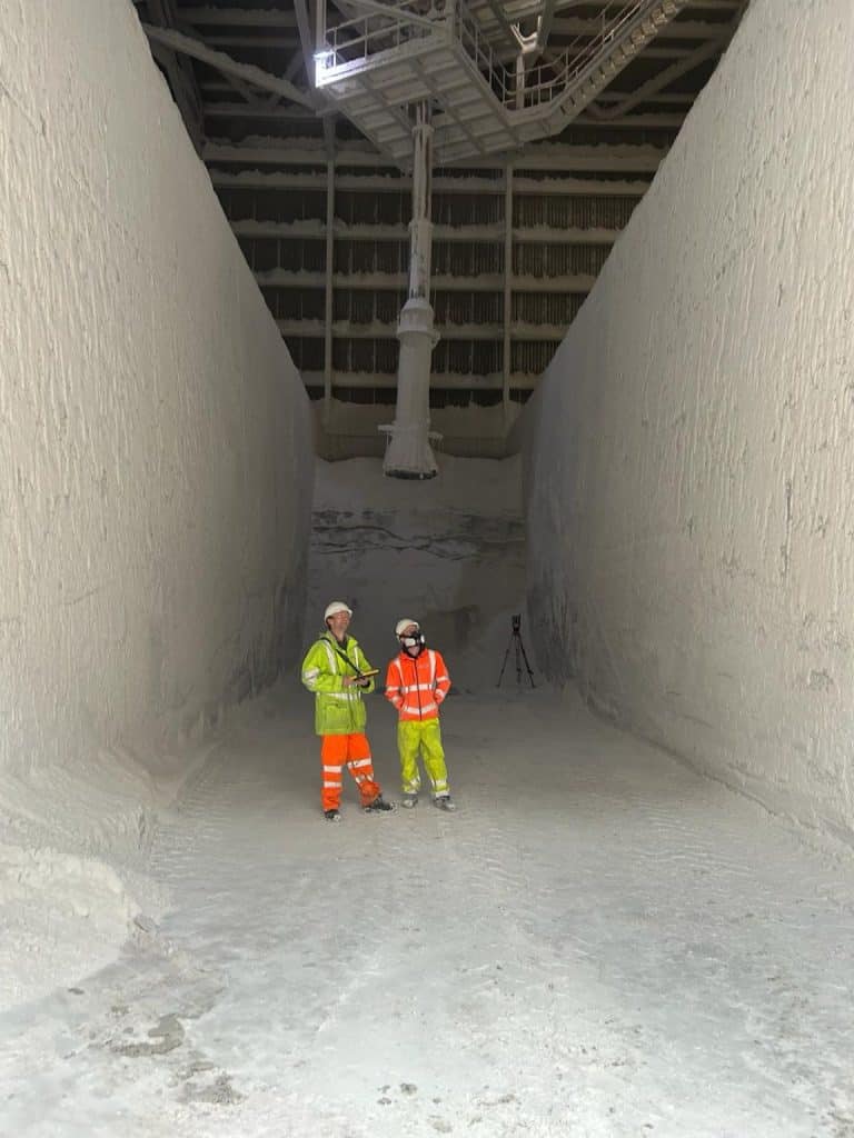
Case Study: Industrial Laser Scanning, Saltburn-by-the-Sea
This one had nothing to do with the film — though the temptation to make a Saltburn joke was apparently difficult to resist. The site itself told a different story entirely: a large-scale industrial facility in Saltburn-by-the-Sea, filled floor to ceiling with what appears to be salt storage — a cavernous, dusty, visually extraordinary industrial environment that presented our teams with some of the most challenging scanning conditions we encounter.
Dust is one of the most disruptive environmental factors in laser scanning — suspended particulate matter scatters the scanner’s laser returns, degrading data quality and requiring careful methodology and scanner positioning to ensure comprehensive, reliable coverage. With Trimble X7 scanners deployed across the facility and surveyors navigating carefully through the site, the team worked methodically through a genuinely tricky environment, minimising disruption to ongoing site operations throughout. The result: comprehensive point cloud data captured across the full facility, delivered despite the conditions, with the kind of grit and effort from the site team that demanding industrial environments demand. A real grind — in every sense.
Teesside's Development Landscape
Teesside's Development Landscape
The Tees Valley is one of the most energetically developing areas in the North East, driven by the Tees Valley Combined Authority’s ambitious investment programmes and the transformational South Tees Development Corporation — which is overseeing the regeneration of the former SSI steelworks site at Redcar into one of the largest development opportunities in the UK, targeting advanced manufacturing, offshore energy, and logistics investment across a 4,500-acre site. Alongside South Tees, investment in Middlesbrough’s town centre, Stockton’s Riverside development, and the wider Tees Valley’s residential and infrastructure pipeline creates sustained, significant demand for professional survey services across the area. Saltburn-by-the-Sea and the East Cleveland coast sit within Redcar and Cleveland Borough Council, whose current planning framework is the Redcar & Cleveland Local Plan, adopted May 2018. A new Local Development Scheme covering 2025–2028 has been published, setting the timetable for a new Local Plan to replace the current one. Middlesbrough and Stockton fall within their own unitary authority areas, each with their own Local Plans currently in various stages of review and renewal.
Why Choose Site Surveying Services in Teesside?
Why Choose Site Surveying Services in Teesside?
Industrial scanning specialists
our Saltburn facility commission demonstrates our capability in the most demanding industrial environments, with dust, restricted access, and complex layouts all handled professionally
Trimble X7 capability
rapid, high-precision scanning suited to large industrial facilities requiring comprehensive coverage under challenging conditions
Minimal disruption
experienced in working within live industrial operations without disrupting ongoing site activities
Nationwide reach
regular travel to the North East as part of our national operations, with transparent travel costs included in all quotations
Full service range
laser scanning, topographic surveys, utility mapping, setting out, and monitoring all in-house
Competitive, transparent pricing
no city-centre overheads, straightforward transparent fees
Frequently Asked Questions
Frequently Asked Questions
Do you carry out laser scanning of large industrial facilities in Teesside?
Yes — and our Saltburn-by-the-Sea commission is a strong example of our capability in demanding industrial environments. Dust, restricted access, complex geometry, and the need to minimise disruption to live operations are all challenges our team navigates routinely. We deploy multiple Trimble X7 scanners where site scale demands it, planning our scan positions carefully to ensure comprehensive coverage whatever the conditions.
How do you manage laser scanning in dusty industrial environments?
Dust is one of the most challenging factors in laser scanning — suspended particles scatter laser returns and can degrade data quality significantly. Our approach involves careful scanner positioning to minimise the impact of airborne particulate, strategic use of multiple scan positions to ensure overlap and redundancy, and thorough quality checking of data during and after the survey. Our Saltburn commission was completed successfully despite substantial dust throughout the facility.
Can you carry out surveys at the South Tees Development Corporation site and former steelworks area?
Yes. The South Tees site represents one of the largest development opportunities in the UK, and the scale and complexity of surveys required across its 4,500 acres is exactly the kind of commission our technology and team are suited to. Contact us to discuss your specific requirements.
Do you carry out topographic surveys for planning applications in the Tees Valley?
Yes. The South Tees site represents one of the largest development opportunities in the UK, and the scale and complexity of surveys required across its 4,500 acres is exactly the kind of commission our technology and team are suited to. Contact us to discuss your specific requirements.
Do you survey coastal sites near Saltburn and along the East Cleveland coast?
Yes. The North Yorkshire coast around Saltburn, Marske, and Redcar presents specific survey considerations around coastal access, cliff stability, and tidal environments. We are experienced in coastal survey work and can provide topographic surveys, UAV aerial capture, and other services along the East Cleveland coastline.