


 Leeds
Leeds Doncaster
 Sheffield
 Bradford
 Hull
Hull Halifax
 Sunderland
 Newcastle
 Middlesborough
 Yorkshire Moors
 Teesside
 Cumbria
 Harrogate
 York
York Yorkshire Dales
 Northumberland
 Goole
Goole Carlisle
 Keswick
 Kendal
 Barrow-in-Furness
 Lancaster
 Blackpool
 Morecambe
 Southport
 Liverpool
 Wigan
Wigan Manchester
 Blackburn
 Burnley
 Forest of Bowland
 Oldham
 Chester
 Stockport
 Peak District
 Skipton
 Crewe
Crewe Rotherham
 Stoke
Stoke Driffield
Surveying Services North West
Site Surveying Services in Carlisle, Cumbria
Carlisle is the principal city of Cumbria and the gateway to the North West — a city of Roman origins, medieval walls, and an exceptional concentration of listed buildings and historic assets, sitting at the crossroads of the M6 corridor between England and Scotland. It is also a city of significant and growing development activity, with major infrastructure investment, housing growth, and a transformational Garden Village scheme on its southern edge set to deliver thousands of new homes over the coming decades.
Site Surveying Services has delivered a substantial volume of professional surveying work across Carlisle — from Grade I listed building laser scanning commissions of national significance to crane rail surveys, commercial setting out, and retail laser scanning. Our North West teams are well connected to Carlisle via the M6 and can mobilise quickly for projects of any scale across the city and the wider Cumberland area.
Whether your project involves Carlisle’s extraordinary heritage assets, its active commercial and industrial estate, or the new development sites opening up across the city’s edges, we bring the technology, expertise, and local knowledge to deliver accurately and on programme.
Our Surveying Services in Carlisle
We offer a comprehensive range of professional surveying services to clients across Carlisle and the wider Cumberland area:
3D Laser Scanning & Point Cloud Production Carlisle
full-colour, high-density point cloud surveys for Grade I and Grade II listed buildings, commercial properties, retail interiors, and industrial structures
UAV / Drone Surveys Carlisle
aerial data capture for large sites, heritage estates, and difficult-access structures
Crane Rail Surveys Carlisle
precision levelling and inspection surveys for overhead crane beam alignment and tolerances
Setting Out Services Carlisle
precise construction setting out for commercial, residential, and civil engineering projects involving cranes and heavy equipment
Sectors We Serve in Carlisle
Our Carlisle project portfolio spans the full breadth of the city’s built environment activity:
Heritage & Conservation Carlisle
laser scanning and point cloud surveys of Carlisle's exceptional Grade I and Grade II listed buildings, Roman heritage, and medieval fabric
Education Carlisle
surveys supporting university campus development and conversion, including heritage buildings being repurposed for academic use
Commercial & Retail Carlisle
laser scanning and measured surveys for retail units, commercial properties, and mixed-use buildings
Industrial & Manufacturing Carlisle
crane rail surveys, setting out, and industrial site surveys across Carlisle's employment estates
Infrastructure & Civil Engineering Carlisle
setting out for large-scale civil and structural works involving cranes and heavy plant
Residential Development Carlisle
topographic and utility surveys for housing schemes across Carlisle and the wider Cumberland area
Public Sector Carlisle
surveys for public buildings, local authority assets, and regeneration projects
Surveying Case Studies & Project Highlights in Carlisle
Case Studies & Project Highlights
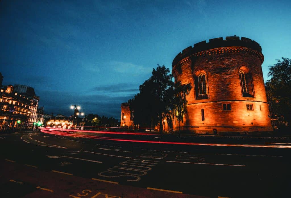
The Citadel, Carlisle — Laser Scanning & Point Cloud Production (Grade I Listed)
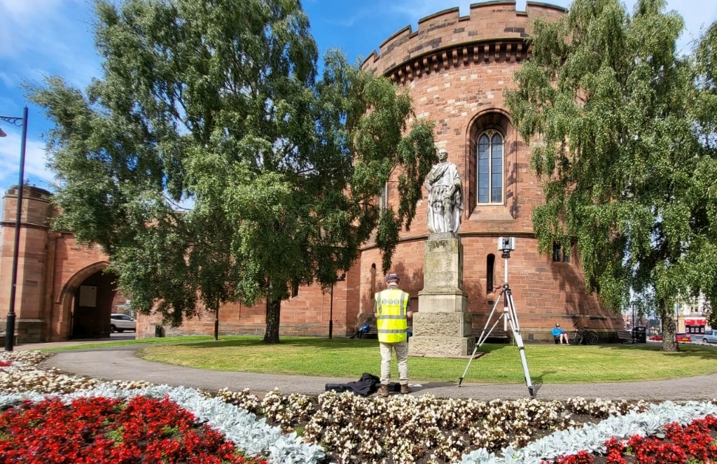
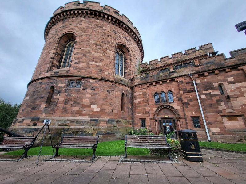
One of our most technically demanding and historically significant commissions — and one of the most rewarding. The Citadel in Carlisle, located on English Street, is a historically exceptional site featuring two Grade I listed buildings: the Nisi Prius Courthouse and the former Crown Court. The project aimed to support the planning and potential conversion of these remarkable historic structures into a campus for the University of Cumbria — a genuinely transformational proposition for both the university and for Carlisle’s city centre. Our team, working collaboratively with surveying colleagues, was responsible for producing detailed, full-colour laser scans of the buildings — capturing the intricate architectural details and current conditions of both structures in comprehensive, high-resolution point cloud form. Advanced laser scanning technology was deployed to document every element of the buildings’ exteriors and interiors, ensuring that nothing was overlooked in buildings of this complexity and historical sensitivity.
Control framework
To achieve the highest possible accuracy across a site of this scale, we implemented a controlled traverse around The Citadel buildings using a Leica Total Station, establishing several control links to create a robust and precise control network tied to the Ordnance Survey National Grid (OSTN). This network was critical for ensuring the accuracy and consistency of all scan data across the full programme.
Scan registration
Black and white checkerboard targets were placed strategically around the site as reference points for the scanner, facilitating precise alignment and integration of the multiple scan positions into a coherent, seamless point cloud dataset.
Aerial survey
Concurrently, surveying colleagues deployed UAVs to carry out aerial surveys of The Citadel, providing a comprehensive overhead view of the site’s layout and surrounding environment. The aerial data complemented the ground-level scans, contributing to a holistic spatial understanding of the site that ground-based scanning alone could not achieve.
The resulting comprehensive, high-accuracy dataset is invaluable for the University of Cumbria’s planning and development team — providing the detailed spatial insights necessary for the thoughtful and respectful conversion of The Citadel into a modern educational campus while preserving its remarkable historical essence. A project that exemplifies our commitment to precision, collaboration, and respect for heritage in every survey we undertake.
Client details
Tritech Ltd
service provided
Laser Scanning & Point Cloud Production
Project timeline
10 days on site / approx. 11 days in the office
Setting Out, Carlisle — Crane Operations
Setting Out
Setting out on a Carlisle construction site where cranes and expensive heavy equipment are very much part of the picture. When cranes are involved, accuracy on day one is non-negotiable — the cost of errors at the setting out stage multiplies rapidly once heavy plant is in play. Our team was on site early, establishing precise reference positions to ensure that everything that followed was built on a sound, accurate foundation. When there’s cranes and expensive equipment involved, it’s always better to be accurate first time.

Crane Rail Inspection, Carlisle — Elevated Survey
Crane Rail Survey / Inspection
An elevated challenge in every sense — literally up on a cherry picker in Carlisle, inspecting and fine-tuning a crane rail at height. Using a combination square for precise measurement in what was a physically demanding and awkward survey environment, our team verified rail alignment and condition to the tolerances required. Methodical, careful, and accurate — exactly as crane rail work demands.

B&M Store, Carlisle — Laser Scanning
3D Laser Scanning
A commercial laser scanning commission at a B&M store in Carlisle — proof that scanning isn’t reserved for cathedrals and castles. Retail environments present their own specific survey challenges: high footfall, cluttered interiors, and the need to work efficiently around trading hours. Our team got a bit more than they bargained for during this particular scan — but delivered the comprehensive interior dataset the client needed regardless.

Historic Buildings, Carlisle — Scanning Programme
3D Laser Scanning
A busy week with site teams up in Carlisle scanning historic buildings across the city — one part of a productive period that simultaneously had teams carrying out river sections in Rutland. It’s a reminder that our nationwide reach operates in parallel: multiple teams, multiple regions, all delivering to the same high standard simultaneously.
Carlisle's Development Landscape
Carlisle's Development Landscape
Carlisle is in the midst of a significant period of investment and planning change. The St Cuthbert’s Garden Village scheme — a nationally designated Garden Settlement on the city’s southern edge — is set to deliver some 10,000 homes and associated employment and infrastructure over a 30-year programme, representing one of the largest planned communities in the North West. The city centre continues to benefit from transport, public realm, and commercial investment, while Carlisle’s healthcare, education, and public sector estates generate consistent survey demand. Carlisle’s planning framework is currently in active transition. Following the creation of Cumberland Council in April 2023 — which replaced Carlisle City Council, Allerdale Borough Council, and Copeland Borough Council — the legacy Carlisle District Local Plan 2015–2030 remains in force as the current planning document for the city. A new consolidated Cumberland Local Plan is now in active preparation, with an Issues and Options consultation completed in autumn 2025 and adoption targeted for March 2028.
Why Choose Site Surveying Services in Carlisle?
Why Choose Site Surveying Services in Carlisle?
Grade I heritage specialists
The Citadel commission demonstrates our capability on the most sensitive and complex listed building surveys in Cumbria
OSTN control networks
precise, nationally-referenced control frameworks ensuring accuracy and consistency across large, complex multi-building sites
Collaborative capability
working alongside other specialist survey teams where project scale demands it, without compromising on data quality or integration
Full sector range
from Grade I courthouses and retail stores to crane rail inspections and construction setting out, we cover every project type in Carlisle
North West based, M6 connected
our Clitheroe base puts Carlisle within approximately 75 miles via the M6; fast mobilisation for the whole of the Cumberland area
Dual ground and aerial capability
combining terrestrial laser scanning with UAV aerial survey for comprehensive, holistic site coverage
Frequently Asked Questions
Frequently Asked Questions
Do you carry out laser scanning of Grade I listed buildings in Carlisle?
Yes — The Citadel on English Street is our flagship Carlisle example. We have the technology, methodology, and heritage sensitivity to survey Grade I listed structures comprehensively, establishing OSTN-referenced control networks and deploying checkerboard targets for precise scan registration. The result is a highly accurate, coherent point cloud dataset that supports conservation, conversion, and development planning for even the most sensitive historic assets.
Can you work collaboratively with other survey teams on large Carlisle projects?
Yes. Our Citadel project was delivered collaboratively with another surveying company — combining our ground-level laser scanning expertise with UAV aerial survey capability to deliver a holistic dataset. We are experienced in working within collaborative survey teams and integrating data from multiple sources into a coherent, accurate output.
Do you carry out crane rail surveys in Carlisle?
Do you carry out setting out on construction sites involving cranes in Carlisle?
Yes. When cranes are on site, the cost of setting out errors escalates significantly. Our team delivers precise, reliable setting out from the outset, ensuring that structural and civil engineering works proceed from an accurate spatial foundation — particularly important when heavy plant is involved from day one.