

Land and engineering surveyors based in Lancashire
Virtual Tour 3D
Virtual Tour 3D Lancashire and the North West
Virtual Tour 3D Lancashire and the North West
A photograph shows what a space looks like. A virtual tour lets someone experience it — walking through every room, measuring dimensions, understanding the relationship between spaces, and arriving at a viewing, a purchase decision or a design meeting already familiar with the building.
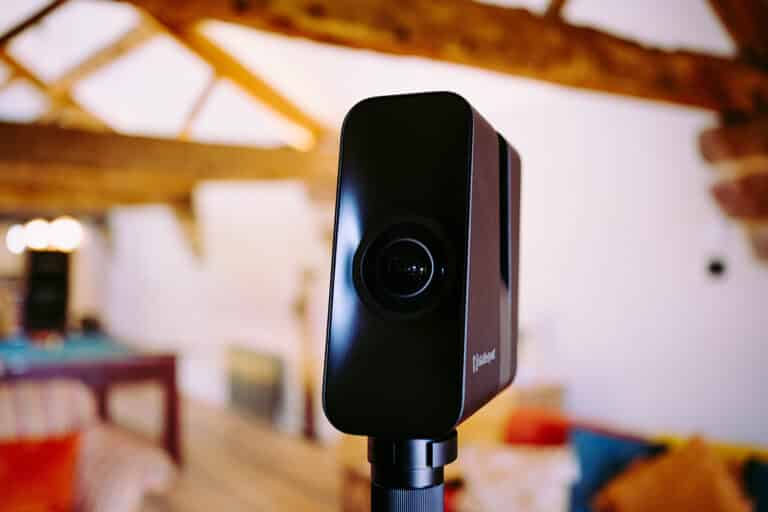
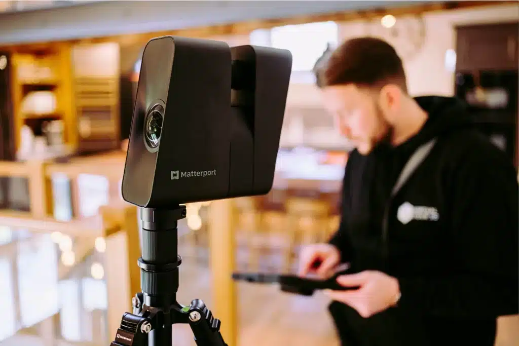
Site Surveying Services creates immersive 3D virtual tours using Matterport Pro 3 technology — the industry-leading platform for professional virtual scanning. From a single site visit, we produce a complete, interactive digital twin of your space that clients, tenants, stakeholders and design teams can explore remotely, from any device, at any time.
We delivered a virtual tour of an eye clinic near the Trafford Centre from scan to completed model within hours of the site visit. We have scanned Eaves Hall, one of Lancashire’s most sought-after wedding and events venues. We have recorded Clitheroe Castle — a Scheduled Ancient Monument in the heart of our home town. And we have created immersive models of historic barns, commercial premises and healthcare facilities across the North West.
The scan is quick. The model is complete. The impact lasts.
What is a Matterport Virtual Tour?
A Matterport virtual tour — sometimes called a 3D tour, a 3D walkthrough or a digital twin — is an interactive, navigable three-dimensional model of a physical space. Using the Matterport Pro 3 camera system, we capture the interior of your building in a series of scan positions. The Matterport platform processes these scans into a fully navigable 3D model that users can explore through a web browser or the Matterport viewer — walking from room to room, looking in any direction, zooming in on details and measuring distances within the model.
Unlike a standard 360° photograph, a Matterport model is genuinely three-dimensional. Every scan position is registered in 3D space relative to all the others, producing a coherent spatial model of the entire building — not a series of disconnected panoramic images. The result is an experience that is significantly more useful for property marketing, heritage recording, building assessment and remote inspection than any photograph or video walkthrough can provide.
What Matterport Pro 3 Delivers
What Matterport Pro 3 Delivers
We use the Matterport Pro 3 camera — the current-generation professional scanning platform from Matterport. The Pro 3 captures both LiDAR depth data and high-resolution photography simultaneously, producing a geometrically accurate point cloud alongside the photographic model. This means the model is not just visually immersive — it is dimensionally accurate and measurable.
Immersive 3D walkthrough
A fully navigable virtual tour accessible via a web link, embedded on your website or shared directly with clients and stakeholders. Works on desktop, tablet and mobile without any specialist software.
Accurate floor plans
Matterport generates floor plans automatically from the scan data, showing room layouts, dimensions and spatial relationships. Indicative measurements for rooms, corridors and openings are available within the model.
Measurement tool
Users can measure distances within the model directly — wall lengths, ceiling heights, opening widths — without returning to site.
Mattertags
information labels placed within the model at specific points, linking to documents, images, videos or external URLs. Used for property information sheets, maintenance manuals, heritage notes and marketing content.
Google Street View integration
Matterport tours can be linked to Google Street View, allowing a user to walk from the street directly into your premises within Google Maps. Particularly valuable for retail, hospitality and commercial premises where discoverability on Google is important.
Virtual Reality compatibility
Matterport models are compatible with VR headsets, enabling a fully immersive virtual site visit for remote stakeholders, design teams and marketing presentations.
our virtual tour 3d case studies
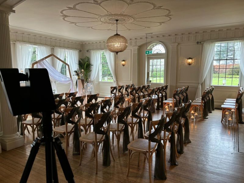
Eaves Hall — Hospitality and Events Venue, Ribble Valley
Eaves Hall is one of Lancashire’s most sought-after wedding and events venues — a Georgian mansion set in landscaped grounds in the Ribble Valley. Our virtual tour captures the full interior of the hall, the function rooms, the bar, the bridal suite and the gardens in a single immersive model. The tour is now embedded on the Eaves Hall website, allowing couples to explore the venue remotely before making an enquiry. The scan was completed in a single site visit and the completed model was live within hours
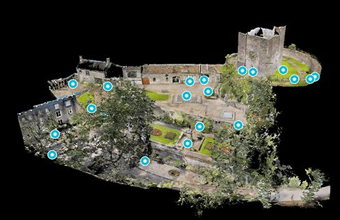
Clitheroe Castle — Scheduled Ancient Monument, Lancashire
Clitheroe Castle is one of the oldest Norman castle keeps in England — a Scheduled Ancient Monument at the heart of our home town. Our virtual tour captures the interior of the keep, the museum spaces and the surrounding grounds, producing a publicly accessible digital record of the castle that supports heritage engagement, education and tourism. A model that preserves the experience of visiting a significant historic structure for anyone who cannot physically attend.

Tithe Barn — Skipton
Virtual tour of the historic Tithe Barn in Skipton — a significant heritage building captured in a complete 3D model that documents the interior geometry, structural fabric and spatial character of the barn. The model supports the venue’s marketing, heritage documentation and event planning for prospective hirers who want to understand the space before visiting.
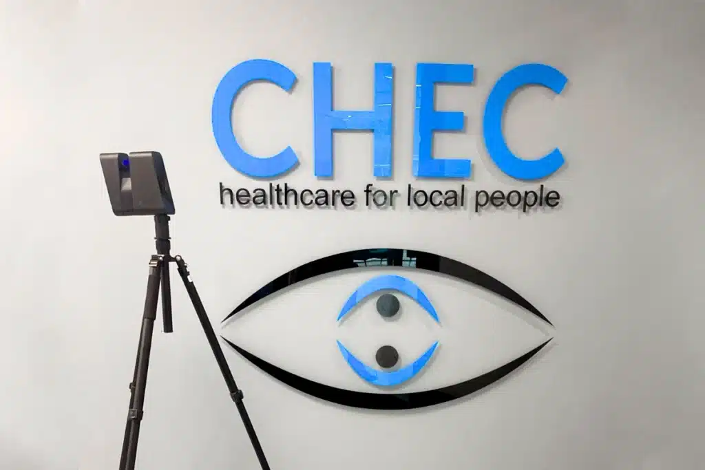
Eye Clinic — Near Trafford Centre, Greater Manchester
A healthcare client near the Trafford Centre required a virtual tour of their clinic for patient orientation and online marketing. Our team completed the scan in a single visit and delivered the completed immersive model within hours. The tour is now used on the clinic’s website to allow patients to familiarise themselves with the environment before their appointment — reducing patient anxiety and supporting the clinic’s marketing to new patients across Greater Manchester.
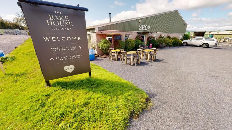
The Bake House — Commercial Premises
Virtual tour of The Bake House — a commercial premises captured as a complete immersive model for marketing and client engagement. Scan to model in hours. Available via web link for remote viewing.
What is a 3D Tour?
What is a 3D Tour?
Benefits of 3D Tours:
Immersive Virtual Experience
With our Matterport surveys, you can invite your clients, customers, or stakeholders to experience a property without being physically present. They can virtually walk through every room, explore details, and get a realistic feel of the space.
Accurate Measurements
Our surveys provide precise measurements of the space, including room dimensions, ceiling heights, and distances between objects. From this data we can produce indicative floor plans. This level of accuracy is crucial for architects, interior designers, and real estate professionals who require reliable data for their projects.
Time and Cost Efficiency
Traditional methods of measuring spaces can be time-consuming and costly. With Matterport surveys, we can quickly capture the entire property and generate accurate measurements and 3D models, saving you valuable time and resources.
Remote Collaboration and Virtual Reality
Whether you're working with a team spread across different locations or collaborating with clients remotely, our 3D Tours enable seamless collaboration and decision-making. Stakeholders can access the survey from anywhere, leave comments, and make informed choices without the need for physical site visits. Virtual Reality headsets can be used to create a truly immersive projection of a project.
Google Street View integration
We can attach the 3D data to existing Google Street View, integrating your property into Google Maps. This enables a client to walk off the street and directly into your shop, showroom or office space.
Marketing Advantage:
In the competitive real estate market, standing out is essential. A 3D Tour enhances your property listings, creating an engaging and interactive experience for potential buyers. It allows them to explore every nook and cranny of the property, increasing their confidence and interest in the listing.
Applications
Applications
who commissions Virtual Tour 3D from us
Commercial property and real estate
Commercial property agents, landlords and developers use virtual tours to market offices, industrial units, retail premises and mixed-use spaces. A virtual tour allows prospective tenants and buyers to conduct a meaningful first viewing remotely — arriving at a physical viewing already familiar with the layout, reducing time-wasting viewings and increasing conversion on genuine interest.
Hospitality and events venues
Eaves Hall in the Ribble Valley — one of Lancashire’s most celebrated wedding and events venues — is one of our case studies. Hospitality venues use virtual tours to help clients visualise their events before booking, to showcase facilities on their websites and to differentiate themselves in a competitive market. A virtual tour of a wedding venue, a conference centre or a hotel can be the deciding factor in a booking enquiry.
Healthcare and clinical facilities
The eye clinic near the Trafford Centre — delivered from scan to completed model within hours of the site visit — is a direct example. Healthcare facilities use virtual tours for patient orientation (reducing anxiety by allowing patients to familiarise themselves with the environment before attending), for marketing to commissioners and referrers, and for staff induction and training.
Heritage and cultural sites
Clitheroe Castle — a Scheduled Ancient Monument — and the Tithe Barn in Skipton are two heritage case studies already live on the site. Heritage bodies, local authorities, museums and historic properties use virtual tours for public engagement and education, for heritage documentation before and after works, and for grant applications where demonstrating public benefit and access is required.
Education and public sector
Schools, colleges and universities use virtual tours for open day marketing, virtual campus tours for remote applicants and facility documentation. Public sector estates teams use them for building condition records and for stakeholder presentations on proposed refurbishment programmes.
Construction and development
Pre-completion virtual tours of commercial and residential developments allow developers to market properties before they are physically accessible. Post-completion virtual tours provide the building handover record, the O&M documentation reference and the baseline for any future works. Construction contractors use virtual tours for progress records and for client reporting on live programmes.
Industrial and logistics
Industrial facility managers and logistics property developers use virtual tours to document existing conditions before fit-out or refurbishment, to provide remote inspection capability for asset managers and to market available units to prospective occupiers.
Our Services
Topographical Surveys
OS-controlled accurate, efficient and cost effective surveys for highways, civils and development. Cad and BIM-ready output.
PAS 128 utility mapping
Providing the location of underground services in 2D or 3D through qualified utility mapping surveys, using advanced GPR and Electromagnetic Location.
Measured building survey
Delivering accurate as-built information that supports design, refurbishment, planning and construction with the latest technology. Producing reliable drawings and digital models.
Laser Scanning
3D laser scanners capture millions of points per second, creating a point cloud which enables the finer details and the physical site to be viewed remotely.
Mobile mapping
For highway engineers, infrastructure managers, local authorities and contractors working on live road schemes, mobile mapping is now the standard for corridor surveys.
3D Machine control
With decades of supporting major earthworks contractors and large-scale infrastructure schemes, we provide reliable machine control across Lancashire and the wider UK.
Setting out engineers
With strong, long-standing relationships across the civil engineering and construction sector, we supply skilled professionals who keep your projects accurate, efficient and on programme.
bathymetric surveys & river surveys
Using modern technology, we capture detailed underwater and river channel information safely and efficiently – delivering reliable data you can trust.
Stockpile surveys & volumetric analysis
Whether a one-off stockpile measurement or regular monitoring, we deliver reliable, repeatable data tailored to your project using advanced technology.
Control Network Installation
Delivering robust and precise site control systems to support every stage of construction in developments, infrastructure schemes or major earthworks.
aerial & drone surveys
CAA-approved drone operations for aerial mapping, photogrammetry and volumetric analysis, providing a comprehensive view of terrain, structures and landscapes.
3D BIM Modelling
Whether you require an as-built Revit model, federated coordination model or detailed digital twin, our team delivers high quality, design-ready outputs.
survey equipment hire
We offer a vast range of surveying and engineering equipment for hire and will always try to beat a comparable quote. Discover the fleet.
monitoring
Providing reliable monitoring surveys across the UK, delivering precise data that supports risk management, compliance and informed decision making throughout a project lifecycle.
Virtual Tour 3D
An immersive experience which instantly transports your clients to your business, guiding them through your space and creating a seamless experience.
Impermeable area surveys
We deliver georeferenced impermeable area data that drainage engineers and planning consultants can work from directly.
CCTV & Drainage surveys
Acoustic & Noise Assessments
We deliver acoustic and noise assessments, supporting planning applications, discharge of conditions and Environmental Impact Assessments.
Topographical Surveys
PAS 128 utility mapping
Laser Scanning
Mobile mapping
Setting out engineers
bathymetric surveys & river surveys
Control Network Installation
aerial & drone surveys
survey equipment hire
monitoring
Impermeable area surveys
CCTV & Drainage surveys
3D Machine control
Acoustic & Noise Assessments
Stockpile surveys & volumetric analysis
3D BIM Modelling
3D BIM Modelling
Virtual Tour 3D
Why choose site surveying services
On site. On spec. On time.
Scan to live model. Same day in most cases.
Matterport Pro 3 on site in the morning. Model processed and link delivered the same afternoon. The pace that pre-completion marketing and condition recording programmes need.
Measurable. Not just viewable.
LiDAR depth data captures accurate geometry alongside the photography. Users measure room dimensions, ceiling heights and distances in the model directly — without returning to site.
Accessible from any device. No software required.
The web link works on desktop, tablet and mobile without downloading anything. The virtual tour your client or tenant can explore on their phone between meetings.
Google Street View integration. On request.
User navigates from Google Maps directly into your premises. The discoverability that matters for retail, hospitality and commercial premises where Google Maps drives footfall.
Frequently Asked Questions
Frequently Asked Questions
What is a Matterport virtual tour?
A Matterport virtual tour is a fully navigable three-dimensional model of a physical space — captured using the Matterport Pro 3 camera system and processed into an interactive digital twin that users can explore through a web browser on any device. Unlike 360° photography, a Matterport model is genuinely three-dimensional, dimensionally accurate and measurable. Users can walk from room to room, look in any direction, zoom in on details and measure distances within the model.
How long does a virtual tour scan take?
The time on site depends on the size and complexity of the building. A straightforward commercial premises, clinic or small venue can typically be scanned in two to four hours. A large hospitality venue, heritage building or multi-level facility may require a full day. We will give you a realistic scan time estimate at the time of booking. Processing of the completed model typically takes a few hours after the scan is uploaded, meaning the tour is often ready to share the same day as the site visit.
How is a Matterport virtual tour accessed?
The completed tour is delivered as a shareable web link and embed code. The link can be shared directly with clients, tenants or stakeholders, and the tour can be embedded on your website. No specialist software or app is required — the tour runs in a standard web browser on desktop, tablet or mobile. For VR viewing, the Matterport app supports compatible VR headsets.
Can a Matterport virtual tour be linked to Google Street View?
Yes. Matterport tours can be integrated with Google Street View, allowing users to navigate from Google Maps directly into your premises via the virtual tour. This is particularly valuable for retail, hospitality and commercial premises where discoverability on Google Maps supports footfall and enquiries. We set up the Street View integration as part of the tour delivery on request.
How accurate are the measurements in a Matterport model?
The Matterport Pro 3 captures LiDAR depth data alongside high-resolution photography, producing geometrically accurate spatial data. Room dimensions, ceiling heights and distances within the model are typically accurate to ±1–5cm for standard indoor environments. For applications requiring higher measurement accuracy — structural assessment, pre-design dimensional verification — a laser scanning measured building survey is the appropriate methodology. We can combine both in a single site visit.
Can you scan heritage and listed buildings?
Yes — and heritage buildings are among our most compelling virtual tour applications. Clitheroe Castle and the Tithe Barn in Skipton are direct examples. The Matterport Pro 3 works in low-light environments and captures the photographic detail and spatial character of historic fabric in a way that photographs cannot. The resulting model supports heritage engagement, grant applications, public access programmes and condition recording.
Can a virtual tour be used as a building record?
Yes. Virtual tours are increasingly used as building condition records — capturing the existing state of a building before refurbishment, alteration or maintenance works. The model provides a timestamped, measurable visual record of the building as it existed at the time of scan, accessible to any stakeholder remotely without requiring a physical visit. For formal as-built records requiring survey-grade accuracy, a laser scan measured building survey is additionally required.
How long is the tour hosted for?
Matterport tours are hosted on the Matterport cloud platform. Hosting is included in the initial delivery and subject to Matterport’s standard subscription terms. We advise on hosting arrangements at the time of delivery and can manage the Matterport subscription on your behalf if required.
Can you add information labels or links within the tour?
Yes. Mattertags — information labels placed within the model at specific points — can link to documents, images, videos or external URLs. Applications include property information sheets, maintenance manuals, heritage interpretation notes, marketing content and wayfinding guidance. Tell us at the time of booking what information labels are required and we will configure them as part of the model delivery.
What areas do you cover?
Our head office is in Clitheroe, Lancashire, with offices in Matlock, Newcastle and Bristol. We deliver virtual tour scanning across the North West, North East, Midlands and South West as primary territories, and nationally. All scanning is carried out by our directly employed team.