


 Leeds
Leeds Doncaster
 Sheffield
 Bradford
 Hull
Hull Halifax
 Sunderland
 Newcastle
 Middlesborough
 Yorkshire Moors
 Teesside
 Cumbria
 Harrogate
 York
York Yorkshire Dales
 Northumberland
 Goole
Goole Carlisle
 Keswick
 Kendal
 Barrow-in-Furness
 Lancaster
 Blackpool
 Morecambe
 Southport
 Liverpool
 Wigan
Wigan Manchester
 Blackburn
 Burnley
 Forest of Bowland
 Oldham
 Chester
 Stockport
 Peak District
 Skipton
 Crewe
Crewe Rotherham
 Stoke
Stoke Driffield
Surveying Services North West
Site Surveying Services in Burnley, Lancashire
Burnley is one of East Lancashire’s most dynamic towns — a place with deep industrial roots, a proud cultural identity, and a borough that continues to attract significant investment and development activity. From ambitious leisure and hospitality developments to housing regeneration and infrastructure improvements, Burnley’s built environment is constantly evolving, and the demand for precise, professional surveying services across the borough reflects that growth.
Based in Clitheroe — just 10 miles from Burnley town centre — our team at Site Surveying Services is perfectly positioned to serve clients across Burnley and the surrounding East Lancashire area. We have direct experience of working on some of Burnley’s most notable development projects, and we understand the range of survey challenges the borough presents, from its urban mill-town fabric to its expansive countryside and leisure estates.
Whether you’re a developer, contractor, architect, or public sector client, we deliver accurate, timely survey data that keeps your project moving.
Our Surveying Services in Burnley
Topographic Surveys Burnley
detailed land and site surveys for planning, drainage design, infrastructure, and development
Measured Building Surveys Burnley
precise floor plans, elevations, and sections for refurbishment, planning, and asset management
3D Laser Scanning Burnley
high-density point cloud surveys for BIM, renovation, structural recording, and heritage documentation
UAV / Drone Surveys Burnley
aerial data capture for large or complex sites, rural estates, and infrastructure works
Sectors We Serve in Burnley
Leisure, Hospitality & Tourism Burnley
surveys supporting major leisure resort expansions, spa facilities, hotel developments, and commercial leisure buildings
Housing & Regeneration Burnley
topographic and utility surveys for residential schemes and borough-wide regeneration programmes
Commercial & Industrial Burnley
surveys for commercial property, industrial estates, and employment land development
Infrastructure & Highways Burnley
topographic and setting out surveys for roads, utilities, and public realm
Case Study: The Woodland Spa, Crow Wood — Pool Survey
Case Study: The Woodland Spa, Crow Wood — Pool Survey
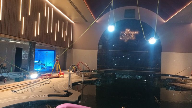
service provided
Survey & Final Checks
Project Details
£17m Extension, Crow Wood Resort, Burnley
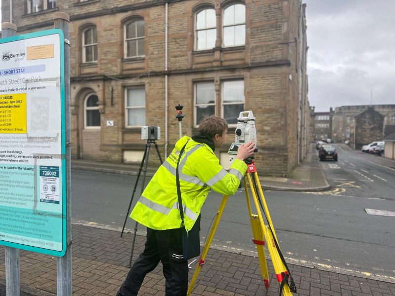
Colne Town Centre
Colne Town Centre
Client details
Lancashire County Council
service provided
Topographical Survey
Project timeline
3 days on site approx. 2 days in the office
Burnley's Development Landscape
Burnley's Development Landscape
Burnley has built a reputation as one of the North West’s most resilient post-industrial towns, balancing the preservation of its historic character with genuine economic ambition. The town’s designation as one of 55 towns receiving government funding through the long-term investment programme has brought additional momentum to regeneration priorities, with local communities and the Town Board shaping how that investment is targeted across employment, public space, culture, and community wellbeing.
The borough continues to deliver strong housing numbers — consistently exceeding Local Plan targets — and the wider leisure, hospitality, and commercial sectors around Crow Wood, the town centre, and East Lancashire’s road and rail corridors continue to generate significant development and refurbishment activity.
Burnley’s planning framework is guided by Burnley’s Local Plan 2012–2032, adopted July 2018 and reviewed in July 2023 — confirmed as current and not requiring update.
Why Choose Site Surveying Services in Burnley?
Why Choose Site Surveying Services in Burnley?
Right on your doorstep
based in Clitheroe, we are just 10 miles from Burnley and can mobilise quickly for any project type
Proven local experience
we have delivered survey work on some of Burnley's most high-profile recent development projects
Versatile across sectors
from luxury leisure resorts to industrial land, heritage buildings to new-build residential, we cover the full range
Advanced technology
3D laser scanning, UAV surveys, GPR utility mapping and total station surveying, all in-house
Responsive service
quotations typically within 24 hours, with fast mobilisation once instructed
Competitive pricing
no inflated city-centre overheads; straightforward, transparent fees
Frequently Asked Questions
Frequently Asked Questions
How quickly can you get to a project in Burnley?
We’re based in Clitheroe, approximately 10 miles from Burnley town centre. For most project types we can be on site within 24–48 hours of instruction. Call us directly if you have an urgent requirement.
Do you carry out surveys for leisure and hospitality developments in Burnley?
Yes — our work at The Woodland Spa at Crow Wood is a good example. We support leisure and hospitality projects at all stages, from pre-planning topographic surveys and measured building surveys through to construction checking and as-built records.
Can you survey rural and countryside sites around Burnley?
Absolutely. The Burnley area includes a significant amount of open countryside, estate land, and rural development sites — particularly toward Pendle Hill, the Forest of Bowland, and the Ribble Valley fringes. Our UAV survey capability is particularly well suited to large rural sites, providing comprehensive aerial data efficiently.
Do you work on housing and regeneration projects in Burnley?
Yes. We have experience supporting residential developers and housing associations on topographic, utility, and setting out surveys across East Lancashire and the Burnley borough. We understand the pace requirements of residential development and deliver promptly.
What survey services do you provide for Burnley's industrial and heritage buildings?
We carry out measured building surveys and 3D laser scanning on a wide range of building types, including the mill buildings, textile heritage structures, and industrial properties that are characteristic of East Lancashire. Laser scanning is particularly effective for complex or historic structures, capturing accurate data with minimal disruption.
Can you provide BIM-ready data for construction projects in Burnley?
Yes. Our laser scanning and total station survey outputs can be delivered as point cloud data, processed BIM models, or CAD drawings to your specification. We work to agreed formats and coordinate with your design and construction teams throughout.