

Successful planning outcomes depend on clear, accurate site information.
Surveying for Planners & Consultants.
One Trusted Partner.
Need the full package?
Survey Data That Supports Planning Decisions — and Withstands Scrutiny.
Survey Data That Supports Planning Decisions — and Withstands Scrutiny.
Planning consultants, transport consultants and environmental consultants share a common requirement that distinguishes them from every other professional that commissions survey: the data they use does not just inform their work — it enters the public domain, is scrutinised by local planning authorities, statutory consultees and appellants, and in some cases is tested before a planning inspector.
Survey data that is inaccurate, under-specified or produced by an unaccredited firm does not just cause a professional problem. It causes a planning problem — requests for further information, holding objections from statutory consultees, conditions attached to consents, and in the worst case an appeal based on evidence the survey should have anticipated. Site Surveying Services delivers survey data for planning submissions, transport assessments, environmental reports, heritage applications and development viability work across Lancashire, the North West and nationally. OS-controlled, georeferenced, produced by an RICS-regulated and Constructionline Gold accredited firm, with a clear methodology statement on every survey. The data that arrives with your planning consultant or transport engineer is data that can be defended in any room.
Survey across the planning process — by consultant type
Planning consultants
The survey data that supports a planning submission needs to do several things simultaneously. It needs to be accurate enough to support the scheme design. It needs to be detailed enough to satisfy the LPA’s validation requirements. It needs to be georeferenced to OS National Grid so it is compatible with the authority’s own mapping and GIS systems. And it needs to be dated — planning authorities often specify that topographic surveys must have been completed within a defined period before submission, and a survey that falls outside that window can delay validation.
What planning consultants typically need from us:
Topographic survey to OS National Grid, tied to Ordnance Datum Newlyn — supporting planning drawings, site layout, drainage strategy, access design and the location plan within the planning application. Measured building survey where existing structures are involved in the proposal. Utility mapping at desktop level minimum to support drainage and services design within the planning submission — and at PAS 128 QLC standard where the local planning authority or drainage consultant requires physically verified service data.
The questions that matter for planning submissions:
Is the topographic survey dated within the LPA's acceptable window for the submission? Is the data tied to OS National Grid and will it overlay correctly with the LPA's base mapping? Has the measured building survey captured everything the heritage officer will scrutinise on a listed building application? Is the survey firm RICS regulated and Constructionline Gold — and can that be evidenced quickly if the LPA requests it?
Survey across the planning process — by consultant type
Transport consultants
Transport assessments, transport statements and travel plans are among the most technically scrutinised elements of a planning submission. The survey data that underpins a transport assessment — road cross-sections, junction geometry, visibility splay dimensions, footway widths, carriageway levels — is frequently tested by the highways authority during the consultation process. If the survey is wrong, the transport assessment is wrong. If the transport assessment is wrong, the highways objection follows.
What transport consultants typically need from us:
Road cross-sections and longitudinal profiles along the site frontage and approach routes. Junction geometry — carriageway widths, turning radii, lane marking positions, kerb lines. Visibility splay measurement — the dimensions that determine whether the proposed access achieves the required sightlines under the relevant design standard. Pedestrian and cycling infrastructure survey — footway widths, dropped kerb positions, crossing facilities, cycle lane markings. Public transport infrastructure — bus stop positions, shelter dimensions, boarding areas.
The questions that matter for transport assessments:
Have the visibility splay measurements been taken from the correct measurement point, at the correct eye and object heights for the design speed of the road? Have carriageway widths been measured at multiple points along the approach — not just at the widest point? Is the survey data in a format that overlays correctly with the Ordnance Survey base mapping used in the transport assessment drawings?
Survey across the planning process — by consultant type
Environmental consultants
Environmental consultants and environmental impact assessment practitioners need survey data that supports flood risk assessments, ecological assessments, noise assessments, air quality modelling, landscape and visual impact assessments and environmental baseline studies. Each of these has its own survey specification requirements — and the common thread is that the data needs to be accurate, georeferenced and methodologically documented.
What environmental consultants typically need from us:
Topographic survey for flood risk assessments — ground levels, drainage features, watercourse banks, flood plain extents and all features relevant to the flood risk assessment methodology. Bathymetric survey of watercourses — bed levels, channel cross-sections, culvert profiles and hydraulic structure geometry for flood modelling. UAV LiDAR for large-area terrain modelling, vegetation mapping and landscape assessment — particularly where the assessment area extends beyond practical ground survey coverage. Watercourse and habitat boundary mapping for ecological assessments where precise habitat area measurement is required for the Biodiversity Net Gain metric calculation.
The questions that matter for environmental assessments:
Is the flood risk survey data compatible with HEC-RAS or InfoWorks ICM — and has the deliverable format been agreed with the hydraulic engineer? Has the DTM been produced from LiDAR data with vegetation removed — or is it a DSM that includes tree canopy heights as part of the ground elevation? Is the survey dated and georeferenced in a way that satisfies the Environment Agency's data submission requirements?
Survey across the planning process — by consultant type
Heritage consultants
Heritage consultants working on listed building applications, scheduled monument consent applications, conservation area applications and heritage impact assessments need survey data that captures the existing fabric of a building or site with a level of accuracy and completeness that conventional tape survey cannot always achieve. A heritage officer reviewing a listed building application that is based on inadequate survey drawings will request further information. A Historic England consultant reviewing a scheduled monument consent supported by surface survey alone may object.
What heritage consultants typically need from us:
Measured building survey of listed and historic buildings — floor plans, elevations, sections and 3D models at the scale and accuracy the heritage assessment requires. Laser scanning for complex historic fabric where the existing geometry, irregular surfaces and fine architectural detail require denser data capture than tape survey can provide. Topographic survey of the setting and surroundings for heritage settings assessments and landscape character work. Archaeological earthwork survey where the heritage assessment requires a record of earthworks, surface features and topographic relationships within a scheduled monument or heritage asset.
The questions that matter for heritage applications:
Does the measured building survey capture the level of detail Historic England and the conservation officer will require at this consent level? Is the laser scan data available as a point cloud alongside the drawn survey — for use by a conservator or structural engineer later in the design process? Has the coordinate system been agreed with the heritage consultant so the survey ties to the archaeological data and other records?
Survey across the planning process — by consultant type
Viability and development consultants
Development viability assessments and residual land value calculations depend on cost assumptions that are informed by the physical characteristics of the site. A topographic survey that reveals significantly more challenging ground conditions than the viability assessment assumed — deeper drainage runs, steeper gradients requiring retaining structures, contamination indicators at surface — is information that changes the residual land value calculation. Getting the physical picture right at viability stage protects the advice the consultant gives to the client.
What viability and development consultants typically need from us:
Indicative topographic survey at viability stage to confirm ground conditions, gradients, drainage characteristics and the development constraint features that affect cost assumptions. UAV survey for large sites where a rapid ground conditions overview is needed without the cost of a full topographic survey. Desktop utility records to flag major service constraints that would affect infrastructure cost assumptions.
Surveying Services
Most Used by Planners and Consultants.
Surveying Services Most Used by Planners and Consultants.
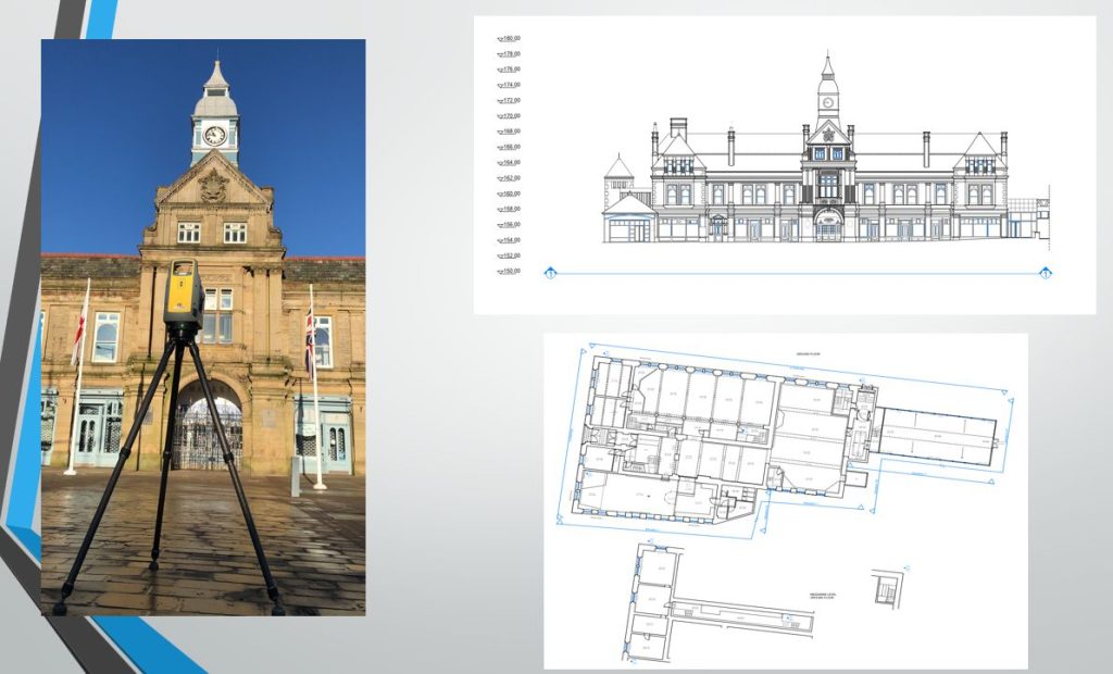
Measured building surveys
Topographic survey
OS-controlled, georeferenced, dated — for planning submissions, transport assessments, environmental reports and viability work across Lancashire, the North West and nationally.
Mobile mapping
Highway corridor survey for transport assessments. Road cross-sections, junction geometry and carriageway levels captured at road speed using the CHCNAV AU20 MMS.
Laser scanning
high-density 3D capture for historic buildings, complex structures and heritage recording where tape survey is inadequate.
UAV survey
Large-area terrain modelling, vegetation mapping, landscape assessment and site overview for environmental and transport assessments.
PAS 128 utility mapping
Underground service data for drainage design, infrastructure cost assessment and pre-application utility constraint analysis.
Bathymetric Survey
Watercourse cross-sections and bed levels for flood risk assessments and hydraulic modelling. EA-compliant deliverables in HEC-RAS and InfoWorks format.
survey for planners & conultants North West
Case Studies: Survey Data in practice
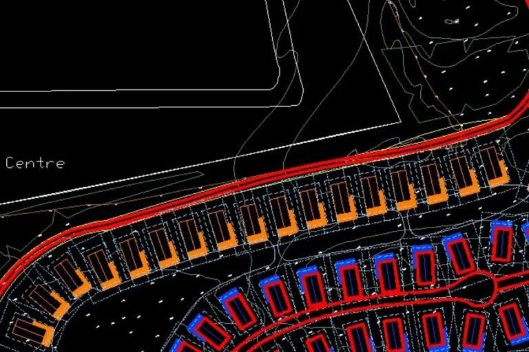
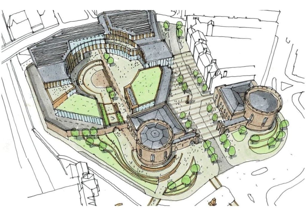
Urban Regeneration Surveys — Darwen, Colne and Accrington
Case Studies: Survey Data in practice
Darwen Market Hall — Surveying for Regeneration
Why choose site surveying services
On site. On spec. On time.
We support planning consultancies, development advisors, and multidisciplinary teams across the UK by delivering accurate, reliable survey data that underpins confident, evidence-led planning decisions from early site appraisal through to determination and beyond. Our surveys provide the clarity required to reduce risk, address planning constraints, and support well-informed recommendations.
At Site Surveying Services, we understand the analytical and regulatory demands faced by planners and consultants. We work closely with planning consultancies, development advisors, and technical specialists to deliver surveys that align with planning strategies, submission requirements, and tight project timescales. Whether supporting small infill sites or complex strategic developments, we tailor our approach to suit each project’s planning context.
Our experience in supporting planning applications allows us to anticipate the information required at each stage of the planning process. From feasibility and site constraints analysis to planning submissions, design coordination, and technical validation, we provide clear, robust survey outputs that integrate seamlessly into planning reports, drawings, and supporting documentation.
We deliver architectural and land surveying services across a wide range of sectors and site conditions, from constrained urban environments to large greenfield and brownfield sites. Our topographical surveys, measured building surveys, and point cloud data give planners and consultants confidence that proposals are based on accurate, defensible site information.
Quality, communication, and consistency are central to our service. By combining technical surveying expertise with a strong understanding of planning workflows and policy requirements, we help ensure projects progress efficiently through the planning system. For planners and consultants seeking dependable surveying support, we provide the data that strengthens submissions and supports successful outcomes.
If you’d like to discuss a site, request a quotation, or need advice on survey requirements for a planning application, our team is happy to help.
fast turnaround
Get a quick quote and a survey team prepared for instruction. When the programme window opens, we're ready.
Industry Accredited
Built on recognised industry standards. Constructionline Gold accredited, CAA Approved, CDM 2015 compliant, and surveys delivered to PAS 128
Nationwide
Coverage across the UK with local knowledge you can rely on. Headquartered in Clitheroe, we know the sites, the contractors and the programmes — backed by the capability to deliver anywhere.
Programme-Critical
Data that works in your environment from day one. BIM to your EIR. CAD to your spec. No reprocessing. No delays to the design team.
Frequently Asked Questions
Frequently Asked Questions
Does a topographic survey need to be tied to OS National Grid for a planning submission?
Yes — for the vast majority of planning submissions. The local planning authority’s mapping, GIS and base data are all referenced to OS National Grid. A survey that is not tied to OS National Grid will not overlay correctly with the LPA’s own plans, which creates an immediate validation problem and potentially a request for further information before the application is registered. Every topographic survey we produce is OS-controlled and tied to National Grid as standard. If the LPA has specific coordinate system requirements, confirm these at the time of instruction.
How current does a topographic survey need to be for a planning application?
Most local planning authorities do not specify an exact currency requirement in their validation checklist — but surveys that are more than two years old are commonly questioned, particularly on sites where ground conditions or built context may have changed. Heritage applications in conservation areas or for listed buildings often require surveys that reflect the current condition precisely — a survey from five years ago that predates recent alterations will not be adequate. We advise on the appropriate currency for your specific application and LPA at the time of instruction.
What survey data does a flood risk assessment require?
This depends on the FRA level. A Level 1 screening assessment typically requires only OS data and basic site information. A Level 2 flood risk assessment requires a topographic survey of the site and its immediate surroundings — ground levels, drainage features, watercourse banks and adjacent flood plain features — to assess the flood risk to the site and the impact on adjacent land. A Level 3 detailed FRA requires a full topographic and bathymetric survey of the site and the relevant watercourse reach, with hydraulic modelling that demonstrates the development will not increase flood risk. We advise on the right survey scope for your FRA level and confirm the deliverable format with your hydraulic engineer at the time of instruction.
What survey is required for a listed building consent application?
At minimum, a measured building survey producing floor plans, elevations and sections of the parts of the listed building affected by the proposed works. For significant alterations or major refurbishment, a full building survey is typically required — captured using laser scanning to record the existing fabric in the detail Historic England and conservation officers require. For scheduled monument consent, a photogrammetric survey and earthwork plan at appropriate scale may additionally be required. The scope should be agreed with the heritage consultant and conservation officer at the time of pre-application — not commissioned after the application is submitted and a request for further information arrives.
Can you produce survey data in a format suitable for the Biodiversity Net Gain metric?
Yes. The Biodiversity Net Gain metric requires accurate habitat areas — which means the survey data underpinning the baseline assessment needs to be georeferenced and reproducible. We produce OS-controlled topographic surveys and UAV-captured imagery that ecological consultants can use directly in their BNG metric calculations, providing accurate site extents, habitat boundaries and land cover data. For post-development monitoring, we can provide repeat surveys tied to the same datum as the baseline to track habitat change and demonstrate BNG delivery over time.
What visibility splay measurements do you take for a transport assessment?
Visibility splay measurement requires the survey to capture ground levels, obstruction heights and positions across the required visibility envelope — from the measurement point at the proposed access, looking in both directions along the carriageway, to the appropriate x-distance and y-distance for the design speed of the road. We take measurements at the correct eye height and object height for the relevant design standard (MfS, DMRB or local authority guidance as applicable) and produce drawings at a scale that clearly demonstrates whether the required sightlines are achieved. If obstructions within the visibility splay are identified, we record them and advise the transport consultant.
What is the difference between a topographic survey and an OS map — and why does it matter for planning?
An OS map is a generalised representation of the landscape produced at national scale. It does not capture individual ground levels, detailed drainage features, precise boundary positions or the fine-grained site-specific information that planning submissions require. A topographic survey is a site-specific, measured record produced to the accuracy and detail the project requires — capturing everything the OS map does not, including spot heights, drainage gradients, boundary features, service covers and contextual detail. For any planning application that involves drainage design, flood risk assessment or detailed site layout, an OS map is not an adequate substitute for a topographic survey. The distinction also matters when planning conditions require survey-quality data as part of a discharge of condition submission.
Are you RICS regulated — and does it matter for planning?
Yes. Site Surveying Services is RICS regulated — Royal Institution of Chartered Surveyors. This matters for planning submissions in two specific contexts. First, it provides the professional indemnity framework that the LPA and planning inspectorate expect when survey data is supporting a planning case. Second, on applications where a statutory consultee such as Historic England or the Environment Agency scrutinises the survey methodology, RICS regulation is one of the signals of professional standing they look for. Our Constructionline Gold accreditation and RICS membership are current and can be confirmed on request.
Can you turn around a survey quickly for a planning programme?
Yes — within the practical constraints of site access, survey scope and programme. We return quotes quickly and mobilise from quote to on site without the delays that cost planning programmes time they cannot recover. If your application has a specific committee date or submission deadline, tell us at the time of enquiry and we will confirm whether the programme is achievable.
What areas do you cover?
Our head office is in Clitheroe, Lancashire, with offices in Matlock, Newcastle and Bristol. We deliver surveys for planning submissions across the North West, North East, Midlands and South West as primary territories, and nationally. All work is carried out by our directly employed team.