


 Leeds
Leeds Doncaster
 Sheffield
 Bradford
 Hull
Hull Halifax
 Sunderland
 Newcastle
 Middlesborough
 Yorkshire Moors
 Teesside
 Cumbria
 Harrogate
 York
York Yorkshire Dales
 Northumberland
 Goole
Goole Carlisle
 Keswick
 Kendal
 Barrow-in-Furness
 Lancaster
 Blackpool
 Morecambe
 Southport
 Liverpool
 Wigan
Wigan Manchester
 Blackburn
 Burnley
 Forest of Bowland
 Oldham
 Chester
 Stockport
 Peak District
 Skipton
 Crewe
Crewe Rotherham
 Stoke
Stoke Driffield
Precision data for sustainable decisions. Survey methodology that matches the environment.
Environmental & Energy Surveying
Environmental and energy projects in the North West present survey challenges that standard construction methodology cannot always address. Wetland sites where ground-based access is restricted or harmful to the habitat. River corridors where the data needed lies beneath the water surface. Wind farm and solar development sites across challenging Pennine, Lakeland and moorland terrain. Flood risk assessments where every level and drainage feature matters to the modelling. Water infrastructure upgrade schemes operating under AMP8 investment where the survey data directly underpins programme-critical design decisions.
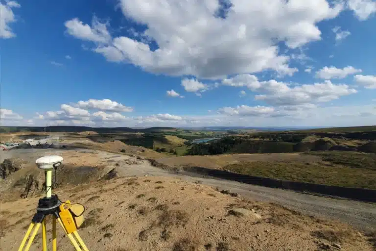
Site Surveying Services has been delivering survey across this sector since 1997 — using UAV LiDAR, unmanned surface vessels, remote sensing and GPS-controlled ground survey to capture data safely and accurately in environments where traditional methods are impractical, too slow or potentially damaging to what is being surveyed. We are Lancashire-based, nationally capable, and our equipment is specifically chosen for the environments this sector demands.
Surveying for Environmental Conservation Projects
Surveying for Environmental Conservation Projects
Strict sustainability targets, sensitive habitats and the constant demand for reliable, compliant data. From wetlands and rivers to wind farms and solar arrays. Even the smallest error can cause delays, increase costs, or risk environmental harm.
Why Accuracy Matters...
Accurate survey data is essential in helping to protect ecosystems and supporting sustainability goals. With reliable information, clients can:
Design responsibly
reducing environmental impact.
Make informed Planning decsions
based on terrain, drainage, and habitats.
Avoid costly rework
caused by inaccurate ground data.
Support regulatory submissions
with precise, verifiable information.
Innovation in Action
Innovation in Action
Our investment in advanced technology, from the CHC RS10 SLAM scanner to UAV platforms with LiDAR and hydrographic drones allows us to deliver datasets that were previously impossible in challenging environments. This innovation reduces site time, minimises disruption to sensitive ecosystems, and ensures every decision is built on certainty.
Supporting biodiversity net gain, carbon reduction and renewable energy development.
The Environmental & Energy Sector in the North West
The Environmental & Energy Sector in the North West
The North West is one of the UK's most active regions for environmental and energy-related survey demand. Several factors drive this:
AMP8 water infrastructure investment
United Utilities’ regulatory investment period running to 2030 has committed billions of pounds of capital works across Lancashire, Cheshire, Cumbria and Greater Manchester. Mains replacement, treatment works upgrades, new pumping stations and reservoir works all require topographic survey, PAS 128 utility mapping, as-built survey and monitoring before, during and after construction. We are already delivering across this supply chain.
Renewable energy development
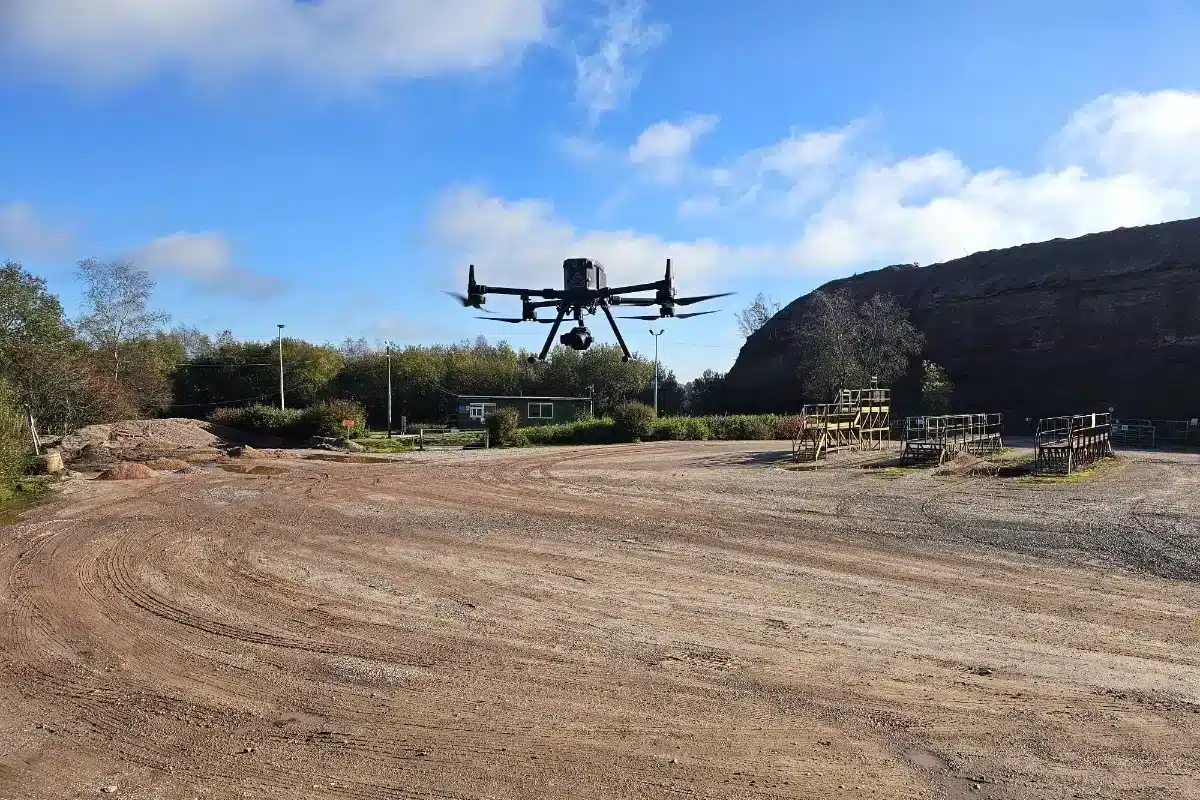
Wind farm development across the Pennines, Bowland Fells, Cumbrian hills and coastal areas of the North West, alongside solar farm development on agricultural land, requires detailed topographic survey at site selection, planning and construction stages. UAV LiDAR survey is increasingly the standard methodology for these environments.
Flood risk management
Lancashire and Greater Manchester have some of the most complex flood risk environments in northern England. The River Ribble, the River Mersey, the River Irwell, the River Lune and numerous smaller watercourses all require regular topographic and bathymetric survey to support flood risk assessments, drainage design and flood defence schemes.
Biodiversity Net Gain
Mandatory BNG requirements for new development have created sustained demand for baseline habitat survey, topographic data for ecological assessments and monitoring programmes that track habitat condition over time.
Environmental Impact Assessment
EIA for infrastructure, energy and development projects across the North West requires accurate topographic data, watercourse survey, habitat and land use mapping, and sometimes long-term monitoring data as baseline evidence.
Project Types We Support
Project Types We Support
Flood Risk Assessments
Topographic survey and bathymetric data to support Level 1, 2 and 3 Flood Risk Assessments across Lancashire, Cumbria and Greater Manchester. OS-controlled, georeferenced and delivered in the format your flood risk engineer requires.
Flood Defence Design & Construction
Topographic survey capturing existing embankment geometry, drainage features, access tracks and all relevant site features before and after flood defence works. Our Didsbury flood defence survey — capturing precise elevation data and drainage paths for a hotel and spa following severe River Mersey flooding — is a direct example of this work.
Wind Farm & Solar Development
Topographic and UAV survey at site selection, planning application and construction stages. Grid connection route survey including PAS 128 utility mapping. As-built survey at handover.
Water Treatment & Distrobution Infrastructure
Topographic survey, PAS 128 utility mapping, monitoring and as-built survey for AMP8 programmes across the United Utilities supply chain. We understand what water sector supply chains require and our accreditations — Constructionline Gold, PAS 128, CDM 2015 — are in place and current.
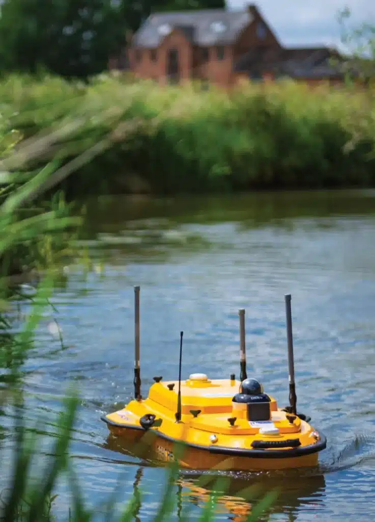
River & Watercourse Management
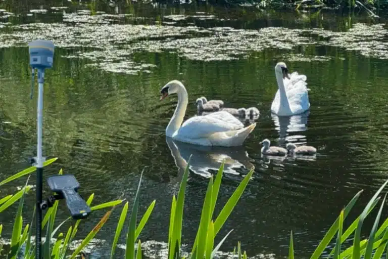
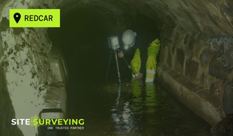
Bathymetric survey, topographic survey and monitoring for flood risk, erosion management, habitat restoration and conservation programmes. The Apache 4 USV allows us to survey watercourses that would be unsafe or ecologically harmful to access on foot.
Wetland & Habitat Restoration
Topographic survey, UAV LiDAR and boundary survey for habitat restoration, rewilding and Biodiversity Net Gain baseline assessment. We have surveyed wetland environments across Lancashire, capturing precise topographic data with minimal ground disturbance.
Environmental Impact Restoration
Topographic data, watercourse survey and habitat mapping as baseline evidence for EIA across infrastructure, energy and development projects in the North West.
Landfill & Waste Management Sites
Topographic and volumetric survey for landfill cap monitoring, waste volume reconciliation and remediation verification.
Reservoir & Dam Inspection
Bathymetric survey of reservoir capacity, dam face inspection, and settlement monitoring on embankment dams for reservoir safety programmes.
Carbon & Habitat Baseline Mapping
UAV-captured topographic and vegetation data for carbon baseline assessments and habitat condition surveys across agricultural and upland environments.
Sustainability & Compliance
Sustainability & Compliance
Whether it’s supporting biodiversity net gain, reducing carbon emissions through efficient survey methods, or helping clients meet regulatory obligations, our job is to collect precise data while also protecting environments and enabling development. As the UK transitions towards renewable energy and climate-resilient infrastructure, accurate surveying is the foundation. We see our role as partners shaping the future of sustainable development, providing the clarity and confidence needed to balance growth with environmental care.
Why choose site surveying services
On site. On spec. On time.
Ecologically sensitive environments.
No personnel in the water. No disturbance to the riverbed or riparian habitat. The survey methodology that satisfies environment agencies.
EA supply chain experience. Accreditations in place.
Constructionline Gold, PAS 128, RICS, CDM compliance and CAA approval — the accreditation profile required for Environment Agency framework supply chains.
UAV LiDAR reaches beneath the vegetation.
DTMs for flood risk modelling, environmental impact assessment and habitat mapping, penetrating tree canopies and dense scrub to capture the bare earth surface.
The same organisation from GPS to CAD.
Our survey team and our CAD team are the same firm. The data that leaves our office has been in-house. No gap. No handoff. No assumptions.
Our Services
Using LiDAR, UAVs, and hydrographic drones to capture precise data in challenging environments.
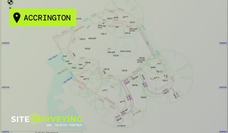
Topographical Surveys
OS-controlled accurate, efficient and cost effective surveys for highways, civils and development. Cad and BIM-ready output.
PAS 128 utility mapping
Providing the location of underground services in 2D or 3D through qualified utility mapping surveys, using advanced GPR and Electromagnetic Location.
Measured building survey
Delivering accurate as-built information that supports design, refurbishment, planning and construction with the latest technology. Producing reliable drawings and digital models.
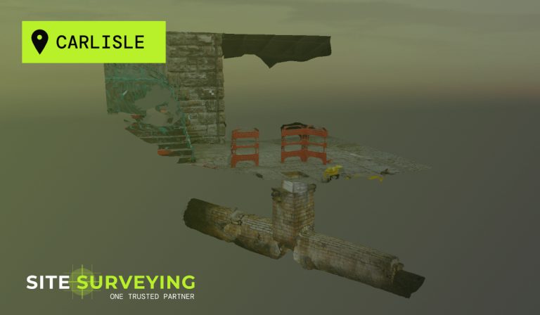
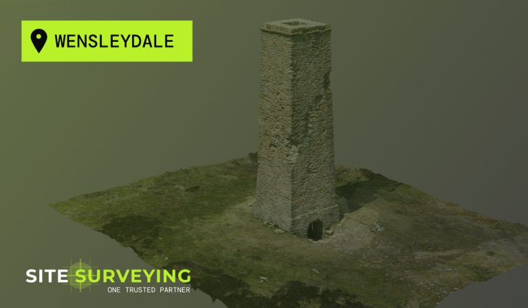
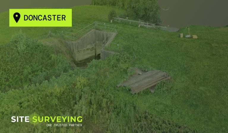
Laser Scanning
3D laser scanners capture millions of points per second, creating a point cloud which enables the finer details and the physical site to be viewed remotely.
Mobile mapping
For highway engineers, infrastructure managers, local authorities and contractors working on live road schemes, mobile mapping is now the standard for corridor surveys.
3D Machine control
With decades of supporting major earthworks contractors and large-scale infrastructure schemes, we provide reliable machine control across Lancashire and the wider UK.
Setting out engineers
With strong, long-standing relationships across the civil engineering and construction sector, we supply skilled professionals who keep your projects accurate, efficient and on programme.
bathymetric surveys & river surveys
Using modern technology, we capture detailed underwater and river channel information safely and efficiently – delivering reliable data you can trust.
Stockpile surveys & volumetric analysis
Whether a one-off stockpile measurement or regular monitoring, we deliver reliable, repeatable data tailored to your project using advanced technology.
Control Network Installation
Delivering robust and precise site control systems to support every stage of construction in developments, infrastructure schemes or major earthworks.
aerial & drone surveys
CAA-approved drone operations for aerial mapping, photogrammetry and volumetric analysis, providing a comprehensive view of terrain, structures and landscapes.
3D BIM Modelling
Whether you require an as-built Revit model, federated coordination model or detailed digital twin, our team delivers high quality, design-ready outputs.
survey equipment hire
We offer a vast range of surveying and engineering equipment for hire and will always try to beat a comparable quote. Discover the fleet.
monitoring
Providing reliable monitoring surveys across the UK, delivering precise data that supports risk management, compliance and informed decision making throughout a project lifecycle.
Virtual Tour 3D
An immersive experience which instantly transports your clients to your business, guiding them through your space and creating a seamless experience.
Impermeable area surveys
We deliver georeferenced impermeable area data that drainage engineers and planning consultants can work from directly.
CCTV & Drainage surveys
Acoustic & Noise Assessments
We deliver acoustic and noise assessments, supporting planning applications, discharge of conditions and Environmental Impact Assessments.
Topographical Surveys
PAS 128 utility mapping
Laser Scanning
Mobile mapping
Setting out engineers
bathymetric surveys & river surveys
Control Network Installation
aerial & drone surveys
survey equipment hire
monitoring
Impermeable area surveys
CCTV & Drainage surveys
3D Machine control
Acoustic & Noise Assessments
Stockpile surveys & volumetric analysis
3D BIM Modelling
3D BIM Modelling
Virtual Tour 3D
Frequently Asked Questions
Frequently Asked Questions
How do site surveys support sustainable design and planning outcomes?
Comprehensive site surveys play a crucial role in sustainable design and planning by providing accurate information about the existing environment, landform, infrastructure and natural features before any design work begins. For architects and planners, survey data — such as detailed topographical maps and aerial/DJI drone imagery — informs decisions about land contours, vegetation, hydrology, and ecology, ensuring buildings are designed in harmony with the natural environment rather than against it. This supports better siting of buildings, efficient water management, and reduced earthworks. Sustainable planning also demands early identification of risks such as flood zones, unstable ground or heritage constraints, all of which are mitigated through high-quality surveys.
For property developers and civil engineers, reliable survey data feeds into site feasibility studies, enabling realistic assessment of build potential, utilities integration and environmental compliance. Accurate surveys also support compliance with planning conditions and environmental regulations, improving the likelihood of timely approvals and future-proofed development outcomes. Integrating survey insights into the design phase ultimately reduces waste, minimises costly revisions and supports regenerative development that meets both regulatory and sustainability goals.
What survey do I need for a flood risk assessment?
A flood risk assessment typically requires a topographic survey of the site and its surrounding area — capturing ground levels, contours, drainage features, watercourses, culverts, flood plain extents and all features relevant to surface water flow. For sites adjacent to or including watercourses, a bathymetric survey capturing riverbed levels, channel cross-sections and flow profiles may also be required. The level of detail depends on the type of FRA — a Level 1 screening assessment requires less survey data than a Level 2 or Level 3 detailed assessment. We advise on the right survey scope for the FRA type at the time of enquiry.
What is a Biodiversity Net Gain survey and what data does it need?
Biodiversity Net Gain is now mandatory for most new development in England under the Environment Act 2021. A BNG baseline requires accurate habitat mapping — identifying, classifying and measuring all habitat types on and around the site before development begins. This typically requires a topographic survey to establish accurate site areas and boundaries, along with UAV photography or LiDAR data to support habitat condition assessment. The Biodiversity Metric requires precise habitat areas, which means the survey data underpinning the baseline needs to be accurate and reproducible. We produce georeferenced topographic data and UAV outputs that ecological consultants can use directly in their BNG calculations.
How do you survey a wetland without disturbing the habitat?
Wetland environments are often too ecologically sensitive for conventional ground-based survey teams. Our approach on wetland sites combines GPS-controlled remote sensing with UAV LiDAR — capturing high-resolution topographic data, vegetation height and ground elevation without personnel walking through the habitat. Where boundary points or control stations are required on the ground, we minimise access to established paths and access points only. The CHCNAV X500 UAV with LiDAR payload can capture a detailed terrain model of a wetland site in a single flight, producing data that ground-based methods would take days to collect — and could not produce at all in inaccessible areas.
Do I need a PAS 128 survey for a water infrastructure or AMP8 scheme?
Yes — on any scheme involving excavation near buried services. This includes AMP8 mains replacement, treatment works upgrade and pumping station installation programmes. Water infrastructure sites often carry decades of buried services — water mains, sewer infrastructure, gas supply, electrical cables and communications — not all of which will be accurately represented in utility records. PAS 128 Quality Level A physically verifies the location of every service. It is the standard that protects the programme from underground strikes and the Principal Designer from CDM compliance gaps. We are PAS 128 accredited and deliver utility mapping across the United Utilities supply chain in the North West.
What survey is required for a wind farm or solar farm development?
Renewable energy development typically requires survey at three stages. At site selection and feasibility — a large-area topographic survey capturing terrain, drainage, existing tracks, boundaries and significant features. UAV LiDAR is increasingly the standard method for this stage, capturing detailed terrain data across large areas quickly and with minimal ground disturbance. At planning application — a detailed topographic survey to support the Environmental Impact Assessment, noise and shadow modelling, visual impact assessment and planning documentation. At construction — grid connection route survey, PAS 128 utility mapping along the cable route, setting-out of turbine or panel positions, and as-built survey at completion.
What is the difference between a topographic survey and a Digital Terrain Model?
A topographic survey is the field data collection process — a surveyor captures ground levels, features and contextual information using GPS and total station equipment. A Digital Terrain Model (DTM) is a deliverable produced from that data — a mathematical model of the bare earth surface, with vegetation and above-ground structures removed. A Digital Surface Model (DSM) includes vegetation and structure heights. Both DTMs and DSMs can be produced from topographic survey or UAV LiDAR data. Environmental consultancies and flood risk engineers commonly require DTMs as the primary deliverable for flood modelling and drainage design. We produce both, and we will confirm which is required for your project at the time of scoping.
Can you survey a river or reservoir without a boat or entering the water?
Yes. We deploy the CHC Navigation Apache 4 — an unmanned surface vessel that captures accurate bathymetric data remotely from the riverbank or reservoir edge without requiring personnel to enter the water. The Apache 4 is fitted with dual GNSS, IMU integration and single or multibeam echo sounders. It navigates the survey route autonomously and streams data in real time. This approach is significantly safer than manned boat surveys on fast-moving or shallow watercourses, and is suitable for rivers, reservoirs, canals, lakes and coastal environments where vessel access is difficult or unsafe.
What monitoring is required on a flood defence scheme?
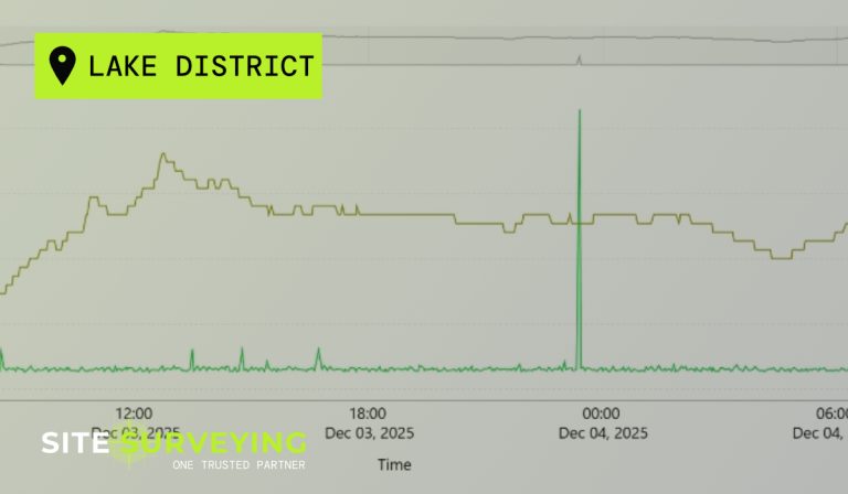
Settlement monitoring is typically required during and after construction on earth embankment flood defences to verify that the new structure is performing as designed and that there is no unexpected movement or settlement. Monitoring may also be required on existing structures adjacent to flood defence works — culverts, walls, bridges — to detect any movement caused by construction activity. Our monitoring programmes use automated instrumentation providing real-time data and clear reporting, giving engineers and asset managers early warning of any movement before it becomes a structural issue.
How do you survey a pipeline or energy corridor?
Pipeline and energy corridor survey requires a combination of topographic survey along the route and PAS 128 utility mapping to locate and verify existing services before any trenching or excavation begins. For longer corridors, UAV survey combined with GPS ground control is the most efficient method — capturing a dense topographic dataset along the full route in a single pass. Mobile mapping using our CHCNAV AU20 vehicle-mounted LiDAR system is also applicable for road-accessible corridors, capturing a complete corridor dataset at road speed. We advise on the most appropriate methodology for your specific route and ground conditions.
What survey data does an Environmental Impact Assessment require?
This varies by project type and scale but typically includes: accurate topographic data for the site and its surroundings; watercourse and drainage survey where relevant; existing land use and boundary data; and in some cases long-term monitoring data as a pre-development baseline. The survey data produced for an EIA needs to be accurate, georeferenced, clearly dated and produced by an accredited firm — because it forms part of the documentation that may be scrutinised by the planning authority, statutory consultees and at appeal. We produce all EIA survey data in-house and can provide full methodology statements confirming the equipment used, the accuracy achieved and the date of survey.
Do you work with Environment Agency supply chains?
Yes. We hold Constructionline Gold, PAS 128 accreditation, RICS regulation and CDM compliance — the standard accreditation profile required for Environment Agency and Lead Local Flood Agency supply chains. We have delivered survey programmes supporting flood risk management, erosion monitoring and environmental programmes across the North West and nationally, working with environmental consultancies and engineering firms operating in the Environment Agency framework supply chain.
What is the right survey for a reservoir safety inspection?
Reservoir safety inspections under the Reservoirs Act 1975 may require a combination of bathymetric survey of the reservoir capacity, topographic survey of the dam crest, embankment faces and spillway, and settlement monitoring if an instrumented monitoring regime is in place. For larger reservoirs, UAV survey combined with bathymetric survey provides the most complete dataset. We advise on the scope required for your specific reservoir type and inspection category.