


 Leeds
Leeds Doncaster
 Sheffield
 Bradford
 Hull
Hull Halifax
 Sunderland
 Newcastle
 Middlesborough
 Yorkshire Moors
 Teesside
 Cumbria
 Harrogate
 York
York Yorkshire Dales
 Northumberland
 Goole
Goole Carlisle
 Keswick
 Kendal
 Barrow-in-Furness
 Lancaster
 Blackpool
 Morecambe
 Southport
 Liverpool
 Wigan
Wigan Manchester
 Blackburn
 Burnley
 Forest of Bowland
 Oldham
 Chester
 Stockport
 Peak District
 Skipton
 Crewe
Crewe Rotherham
 Stoke
Stoke Driffield
Surveying Services North West
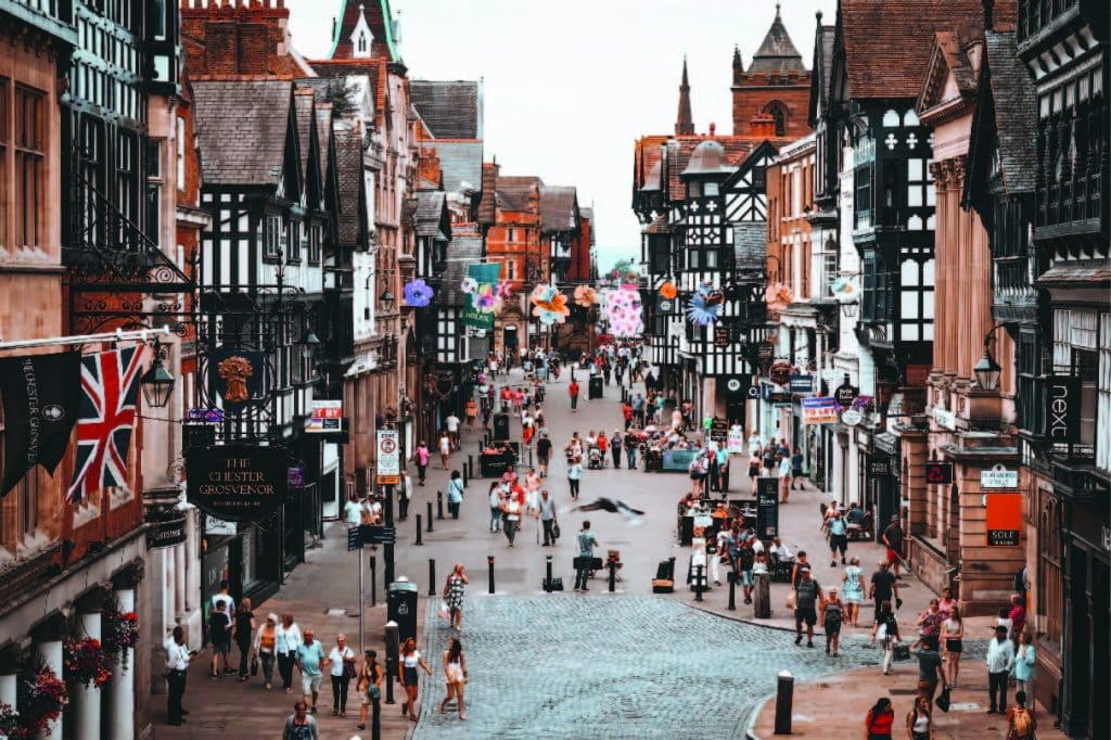
Site Surveying Services in Chester, Cheshire West
Chester is one of England’s most remarkable cities — a place where Roman walls, medieval architecture, and a thriving modern economy exist side by side. Its exceptional concentration of listed buildings, heritage assets, and characterful historic streetscapes makes it one of the most complex and rewarding environments for professional surveyors to work in — and one where technical precision and an understanding of sensitive built environments genuinely matters.
Site Surveying Services delivers professional surveying across Chester and the wider Cheshire West area, working with consultants, contractors, architects, and developers on projects ranging from complex industrial laser scanning to heritage building surveys. We have delivered demanding survey work at some of Chester’s most significant industrial and commercial sites, and we have the technology, team, and track record to handle whatever your project requires.
Whether you need a topographic survey for a planning application, 3D laser scanning of a complex structure, or a measured building survey of a heritage asset, we deliver accurate, timely data you can rely on.
Our Surveying Services in Chester
We offer a comprehensive range of professional surveying services to clients across Chester and Cheshire West:
Topographic Surveys Chester
accurate land and site surveys for planning, flood risk, drainage design, and infrastructure
Measured Building Surveys Chester
precise floor plans, elevations, and sections for heritage assets, commercial buildings, and residential properties
3D Laser Scanning Chester
high-density point cloud surveys for BIM, complex industrial structures, heritage recording, and asset management
UAV / Drone Surveys Chester
aerial data capture for large sites, inaccessible structures, and riverside or waterway environments
Sectors We Serve in Chester
Our Chester project portfolio reflects the diversity of development and investment activity across the city and wider borough:
Industrial & Chemical Processing Chester
laser scanning of complex industrial plant, process facilities, and waterside infrastructure
Heritage & Conservation Chester
measured surveys and laser scanning of Chester's extraordinary stock of Roman, medieval, and historic buildings
Commercial & Retail Chester
surveys for commercial development, refurbishment, and mixed-use regeneration
Public Sector & Civic Chester
surveys for local authority, education, and public buildings
Residential Development Chester
topographic and utility surveys supporting housing schemes across Cheshire West
Case Study: Lostock Works — 3D Laser Scanning
Case Study: Lostock Works — 3D Laser Scanning
The Lostock Works commission, undertaken for Gravitate Consultants, stands as one of the most technically demanding laser scanning projects our team has delivered. The objective was to produce a detailed and precise 3D scan of the entire Lostock Works site near Chester — an intricate industrial complex presenting a combination of environmental, structural, and access challenges that required careful planning and expert execution.
The equipment:
A Leica TS16 total station was used for control alongside two Trimble X7 laser scanners — selected for their high-resolution data capture capability across a complex, heavily cluttered industrial environment. Two experienced surveyors were assigned to the project to provide the expertise and adaptability needed on a site of this character.
The conditions:
The survey was conducted in winter, with snow-covered ground significantly affecting access and ground conditions. More challenging still, brine water being processed on site generated substantial steam, reducing visibility and complicating data capture considerably. These are precisely the conditions that test equipment and methodology — and where careful planning and technical experience make the difference between comprehensive data and gaps.
The site:
The intricate layout of Lostock Works restricted scanner field of view, requiring a higher number of scan positions than a more open site would demand to achieve full coverage. A key feature of the site was an old bridge extended with temporary timber and steel additions, spanning the Trent and Mersey Canal. With only one side accessible from the site, the bridge — which connected to three large industrial drums surrounded by a maze of stairwells and structures — presented some of the most complex scanning conditions of the project. Strategic scanner positioning was essential to capture all necessary detail safely and efficiently.
The result:
Despite the access difficulties, environmental conditions, and structural complexity, our team delivered comprehensive, colourised point cloud data meeting the project’s high specifications — providing Gravitate Consultants with the precise spatial record they needed to support informed decision-making for ongoing and future work at the Lostock Works site.
Client details
Gravitate Consultants
service provided
3D Laser Scanning
Project timeline
5 days on site / approx. 2 days in the office to register as a colourised point cloud
Chester's Development Landscape
Chester's Development Landscape
Cheshire West and Chester Council is currently preparing a new consolidated Local Plan, with an Issues and Options consultation launched in summer 2025. In the meantime, planning decisions across Chester continue to be guided by the two current adopted documents.
Why Choose Site Surveying Services in Chester?
Why Choose Site Surveying Services in Chester?
Complex site specialists
our Lostock Works project demonstrates our capability on the most technically demanding industrial and waterside survey commissions
Heritage experience
Chester's historic environment demands surveyors who understand listed buildings, Roman fabric, and sensitive heritage assets; we do
Advanced scanning technology
Trimble X7 and Leica scanners delivering high-resolution colourised point cloud data, even in difficult environmental conditions
Nationwide reach, local responsiveness
based in Clitheroe, we are within easy reach of Chester and across Cheshire, with fast mobilisation times
Waterway and canal expertise
experience surveying structures on and adjacent to the Trent and Mersey Canal and other waterway infrastructure
Experienced, accredited team
skilled surveyors who adapt to challenging conditions and complex sites without compromising on data quality
Frequently Asked Questions
Frequently Asked Questions
Do you carry out 3D laser scanning of industrial and process sites in Chester?
Yes — and our Lostock Works project is a strong example of our capability in this area. We have delivered laser scanning on complex industrial sites involving restricted access, adverse weather, steam and visibility issues, and intricate multi-level structures. We plan carefully, deploy the right equipment, and deliver comprehensive point cloud data whatever the conditions.
Can you survey heritage and listed buildings in Chester?
Absolutely. Chester has one of the highest concentrations of listed buildings and scheduled monuments of any city in England. We use 3D laser scanning and traditional measured building survey techniques to capture precise, detailed records of historic structures with minimal physical intervention — essential when working in or around Chester’s Roman walls, medieval rows, and Victorian civic buildings.
Do you have experience working near rivers and canals in Chester?
Yes. Waterside surveys present specific access and safety challenges, and we are experienced in working on and around the River Dee, the Shropshire Union Canal, and the Trent and Mersey Canal corridor. Our Lostock Works project involved scanning structures spanning and adjacent to the Trent and Mersey Canal — including bridges with restricted access — so we understand what these environments demand.
What point cloud formats do you deliver for laser scanning projects in Chester?
We deliver colourised point cloud data and can provide output in a range of formats including E57, RCP/RCS (Autodesk), and others to suit your project requirements. Data can be processed into BIM models or CAD drawings depending on your specification.
How do you handle surveying in difficult or adverse conditions like winter or steam-heavy industrial environments?
Through planning, the right equipment, and experienced surveyors who adapt in the field. Our Lostock Works project was conducted in winter with snow on the ground and significant steam reducing visibility — conditions that require careful scan positioning, more scan stations, and methodical execution. We factor challenging conditions into our project planning from the outset.
Can you work with consultants and engineering firms on complex Chester projects?
Yes — our Lostock Works commission was delivered for Gravitate Consultants, and we regularly work as a survey sub-contractor to engineering consultancies, architects, and project managers. We are used to working within multi-discipline teams and delivering to agreed specifications and programmes.