


 Leeds
Leeds Doncaster
 Sheffield
 Bradford
 Hull
Hull Halifax
 Sunderland
 Newcastle
 Middlesborough
 Yorkshire Moors
 Teesside
 Cumbria
 Harrogate
 York
York Yorkshire Dales
 Northumberland
 Goole
Goole Carlisle
 Keswick
 Kendal
 Barrow-in-Furness
 Lancaster
 Blackpool
 Morecambe
 Southport
 Liverpool
 Wigan
Wigan Manchester
 Blackburn
 Burnley
 Forest of Bowland
 Oldham
 Chester
 Stockport
 Peak District
 Skipton
 Crewe
Crewe Rotherham
 Stoke
Stoke Driffield
Surveying Services North West
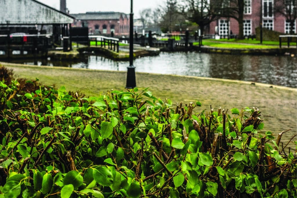
Site Surveying Services in Wigan & Across the Borough
Wigan is a borough with a proud industrial identity and an ambitious future. Stretching across 70 square miles from Standish to Lowton, Orrell to Tyldesley, the borough encompasses fourteen distinct towns and communities — each with its own character, its own built environment, and its own pattern of development and regeneration activity. From coal mining heritage and Victorian mill buildings to modern residential schemes and commercial regeneration, Wigan’s built landscape is as varied as any in Greater Manchester.
Site Surveying Services has delivered professional surveying work across the Wigan borough, including a significant multi-discipline commission in Leigh — one of the borough’s principal towns — that combined measured building survey, utility mapping, CCTV drainage survey, and 3D virtual tour production in a single, phased programme. We understand the range of survey demands that Wigan’s development market places on surveyors, and we bring the technology, expertise, and flexibility to meet them. Based in Clitheroe and well connected to Wigan via the M6 and M61 corridors, our team delivers accurate, timely survey data across the borough and can mobilise quickly to support your project requirements.
Our Surveying Services in Wigan
We offer a comprehensive range of professional surveying services to clients across Wigan and the wider borough:
CCTV Drainage Surveys Wigan
detailed inspection and condition assessment of drainage infrastructure to support development and refurbishment projects
Measured Building Surveys Wigan
precise floor plans, elevations, and sections for heritage buildings, residential conversions, and commercial properties
3D Laser Scanning Wigan
high-density point cloud surveys using Trimble X7 and Leica RTC360 for complex buildings, heritage structures, and BIM production
Utility Surveys & Mapping Wigan
underground service detection and mapping using GPR and electromagnetic location equipment
Sectors We Serve in Wigan
Our Wigan project experience covers the broad range of development and built environment activity across the borough’s fourteen towns:
Residential Conversion & Regeneration Wigan
surveys supporting the conversion of historic and listed buildings to residential use, including heritage capture models and utility assessment
Heritage & Conservation Wigan
measured surveys and laser scanning of Wigan's rich industrial and Victorian heritage buildings
Commercial & Mixed-Use Wigan
surveys for commercial property development, town centre regeneration, and mixed-use schemes
Education & Community Wigan
surveys for former education buildings, community facilities, and public sector assets being repurposed for new uses
Infrastructure & Drainage Wigan
utility mapping and CCTV drainage surveys for development and infrastructure projects across the borough
Industrial & Employment Wigan
surveys for employment sites, former industrial land, and manufacturing facilities across the borough
Surveying Case Studies & Project Highlights in Wigan
Case Studies & Project Highlights
Case Study: Library / College, Railway Road, Leigh — Measured Building Survey, Utility Mapping, CCTV Drainage & 3D Virtual Tour
Phase one — Measured Building Survey:
A multi-phase, multi-discipline commission that showcases the full breadth of what integrated surveying looks like in practice. The project: the redevelopment of a Grade II listed former library and college building on Railway Road in Leigh — a substantial historic structure being converted to modern contemporary flats. The client: Muse Architects Ltd, who needed comprehensive survey data to support the redesign of the building’s interior and maximise the use of available space.
Phase two — Utility Mapping & CCTV Drainage Survey:
Later in the year we returned to the property to carry out utility mapping and a CCTV drainage survey — both essential for assessing the impact of the proposed redevelopment on the local drainage system and underground service network. The utility mapping identified the location and condition of underground services across the site, while the CCTV drainage survey provided a detailed visual inspection of the existing drainage infrastructure. Together, this data was critical for ensuring that the new residential development would not adversely affect local drainage, and that any necessary modifications to the service network could be planned and executed effectively before construction began.
Phase three — 3D Virtual Tour:
Our team was also commissioned to produce a 3D virtual tour of the building — an innovative addition to the project that was designed specifically to support the marketing and pre-sales of the completed flats. The immersive virtual tour gave prospective buyers a comprehensive, navigable view of the property before physical occupation, allowing the developer to market the conversion effectively and attract buyers to what was a distinctive and characterful residential proposition. Taken together, this project — from initial survey capture through to utility assessment and virtual tour production — demonstrates the kind of end-to-end survey service that complex heritage conversion projects demand. One client relationship, one team, three phases of survey support, all delivered with the consistency and accuracy that a Grade II listed building conversion requires.
Client details
Muse Architects Ltd
service provided
Measured Building Survey, Utility Mapping, CCTV Drainage Survey & 3D Virtual Tour
Project timeline
5 days on site / approx. 10 days in the office
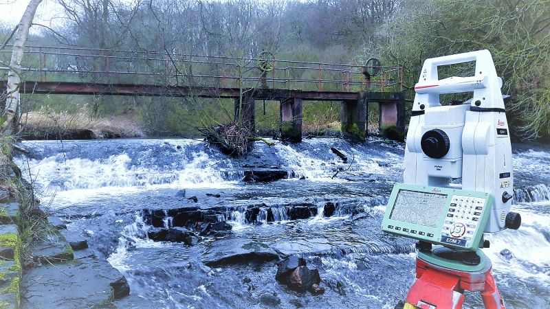
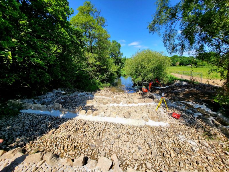
Gathurst Weir — River Survey & Return Survey
River / Environmental Survey
A project that demonstrates something we rarely get to show — the before and after. Gathurst Weir, on the River Douglas in the Wigan borough, was first surveyed by our team in 2020. Three years later, we returned to re-survey the site — this time with an impressive new fish pass installed as part of an environmental improvement programme to restore river connectivity and support the recovery of migratory fish species along the Douglas corridor.
The contrast between the original survey and the return visit tells the story of a genuinely significant environmental project: a weir that once presented a barrier to fish passage transformed into a functioning, naturalised fish pass. Re-surveying completed projects of this kind is one of the more satisfying aspects of our work — seeing what the data helped deliver, and recording the finished result with the same accuracy we brought to the original commission.
Gathurst Weir is a reminder that our survey work extends well beyond buildings and development sites. River surveys, watercourse assessments, and environmental infrastructure surveys are a regular and important part of our portfolio across Lancashire and Greater Manchester.
Wigan's Development Landscape
Wigan's Development Landscape
Wigan is one of Greater Manchester’s largest and most active development boroughs — a 70-square-mile area spanning fourteen towns, each with its own regeneration priorities and development character. The borough’s housing delivery target of 972 new homes per year to 2039 reflects the scale of ambition, and sustained activity across Wigan’s brownfield sites, former industrial land, and town centre regeneration areas is generating consistent demand for professional survey services. The borough’s planning framework is currently in active transition. The current development plan comprises the Wigan Local Plan Core Strategy (2013) — partially superseded by Places for Everyone since March 2024 — alongside saved UDP policies and the Places for Everyone Joint Development Plan (2022–2039), adopted March 2024. A new Wigan Borough Local Plan to 2039 is currently in preparation, with the initial draft consultation closing in June 2025 and the publication version now being prepared ahead of formal submission and examination.
Why Choose Site Surveying Services in Wigan?
Why Choose Site Surveying Services in Wigan?
Multi-discipline capability
as our Leigh commission demonstrates, we can deliver measured building surveys, utility mapping, CCTV drainage surveys, and 3D virtual tours within a single client relationship, across multiple project phases
Heritage conversion specialists
Grade II listed buildings demand the highest levels of survey accuracy and the right scanning technology; our Leigh project delivered exactly that
Trimble X7 and Leica RTC360
two of the most capable scanning platforms available, deployed together for maximum speed and precision on complex building interiors
CCTV drainage surveys
a specialist capability that complements our utility mapping offering, essential for any development project assessing drainage impact
3D virtual tours
combining surveying with marketing support, giving developers and architects an additional sales and management tool from the same survey visit
Well connected to Wigan
accessible via M6 and M61 from our Clitheroe base, with fast mobilisation across all fourteen borough towns
Frequently Asked Questions
Frequently Asked Questions
Do you carry out measured building surveys on listed buildings in Wigan?
Do you carry out CCTV drainage surveys in Wigan?
Can you produce 3D virtual tours as part of a survey commission in Wigan?
Yes. As part of our Leigh Library/College project, we produced a 3D virtual tour to support the marketing of the converted flats. Virtual tours can be produced as a standalone service or as part of a broader survey programme, and are particularly valuable for heritage conversions, new-build residential schemes, and commercial properties where immersive digital presentation adds real value to the sales and marketing process.
Do you carry out utility mapping across the Wigan borough?
Yes — across all of Wigan’s fourteen towns and communities. We use GPR and electromagnetic location equipment to detect and map underground utilities, and we can combine utility mapping with CCTV drainage surveys and topographic surveys in a single coordinated commission.
Can you handle phased survey programmes on heritage conversion projects in Wigan?
Yes. Our Leigh commission was delivered in three phases over the course of a year — initial measured building survey, followed by utility mapping and CCTV drainage, then 3D virtual tour production. Phased programmes of this kind suit heritage conversions well, where survey requirements evolve as the design and planning process progresses. We maintain project continuity across phases and tie all data into consistent control, avoiding the duplication and inconsistency that comes from using multiple survey contractors.