

Land and engineering surveyors Lancashire
Laser Scanning
Based in Lancashire, Operating Nationwide
3D Laser Scanning Lancashire and the North West
3D Laser Scanning Lancashire and the North West
Some sites are too complex, too confined, too active or too sensitive for traditional measured survey methods. Laser scanning is the methodology that solves all of these problems simultaneously — capturing millions of accurate data points per second from a single setup position, without stopping the programme around it, without requiring personnel to access hazardous or restricted areas, and without the risk of missing detail that tape survey cannot reliably record. Site Surveying Services delivers 3D laser scanning across Lancashire, the North West and nationally — for architects, engineers, heritage bodies, industrial facility managers, contractors and developers who need complete, accurate, georeferenced data from buildings, structures, sites and infrastructure that conventional survey cannot adequately capture. Based in Clitheroe, with offices in Matlock, Newcastle and Bristol, our directly employed team handles every stage in-house — from site capture through to point cloud processing and final CAD or BIM deliverable. The data that leaves our office has been checked by the same team that captured it.
The people who commission laser scanning from us are the people whose programme depends on the data being right. We understand what that means.

High Accuracy 3D Laser Scanning Services
High Accuracy 3D Laser Scanning Services
What is a laser scanning survey?
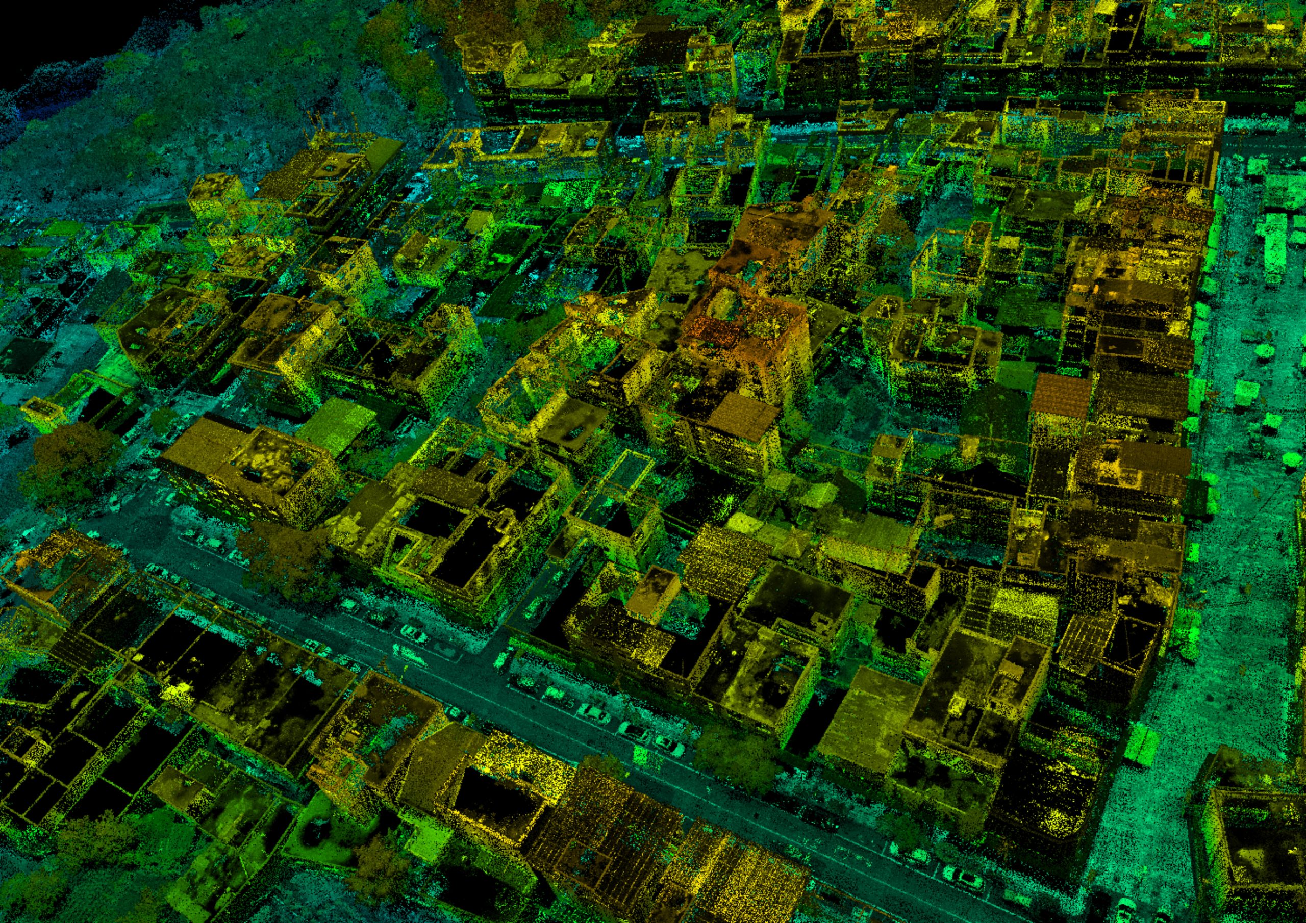
Laser scanning (also called 3D laser scanning or LiDAR) uses pulsed laser technology to rapidly collect millions of highly precise spatial points. These points form a dense 3D point cloud, capturing the physical world in exceptional detail – from terrain and structures to complex infrastructure. Unlike conventional methods that record individual measurements manually, laser scanning gathers comprehensive spatial data in a fraction of the time with excellent accuracy and efficiency.
Why Do You Need a Laser Scanning Survey?
Laser scanning delivers a fast, safe, and highly accurate method of capturing existing site conditions. It is ideal for:
What we capture
Choosing the Right Laser Scanning Method.
Choosing the Right Laser Scanning Method.
Not all laser scanning is the same — and the method that is right for your project depends on the environment, the scale, the access conditions and what the data needs to support. We advise on the right method at the time of scoping. Here is what each approach delivers and when it is most appropriate.
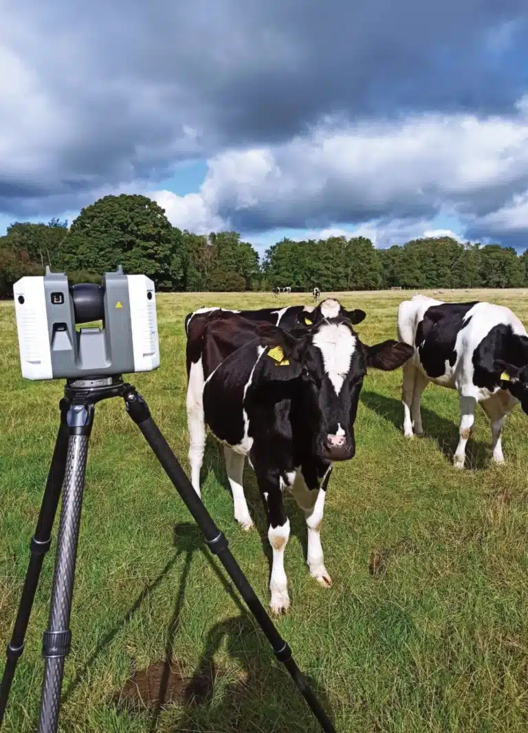
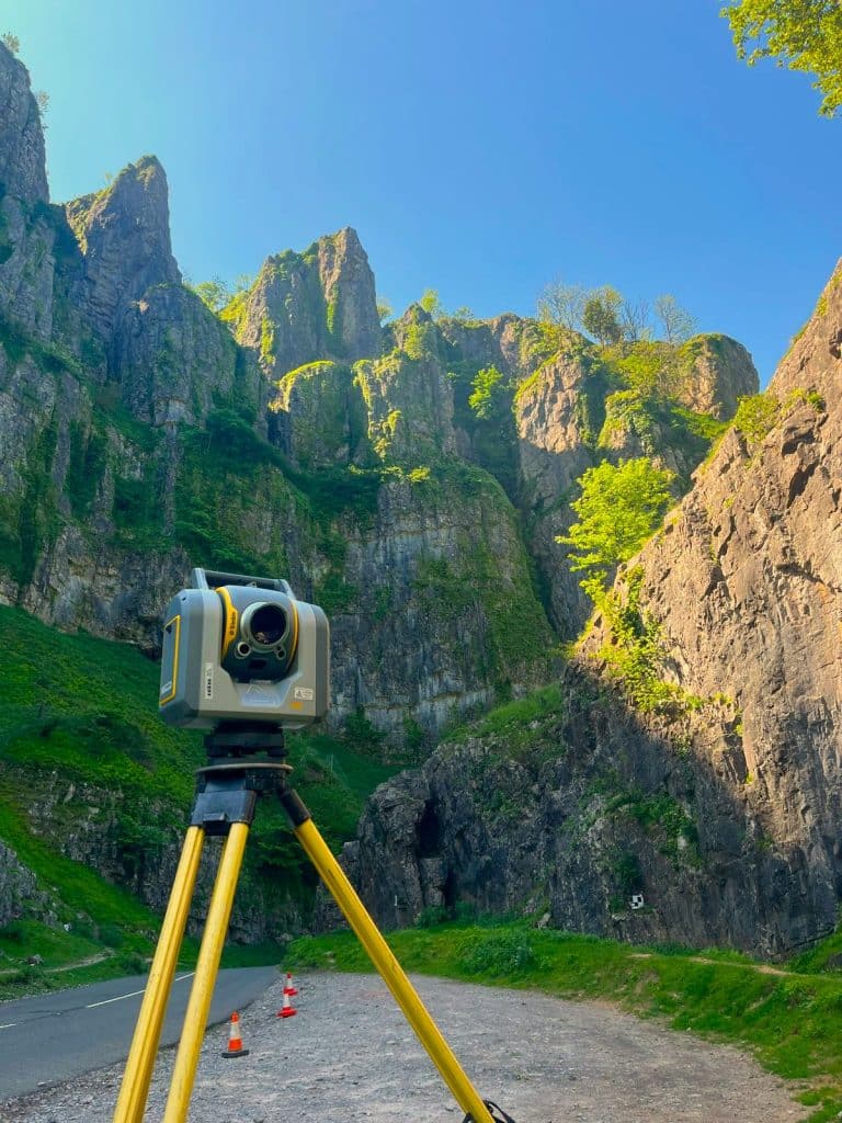
Terrestrial Laser Scanning (TLS)
Static scanning from a fixed position — typically a tripod-mounted instrument that captures a 360° point cloud from each setup point. Multiple scan positions are registered together to produce a complete, seamless model of the site or building. TLS produces the highest-density, most accurate point cloud of the three methods and is the standard approach for measured building surveys, heritage recording, structural condition surveys and BIM model creation. Best for: measured building surveys, heritage and listed buildings, complex facades, confined interior spaces, structural assessment, BIM delivery.
SLAM Scanning (Simultaneous Localisation and Mapping)
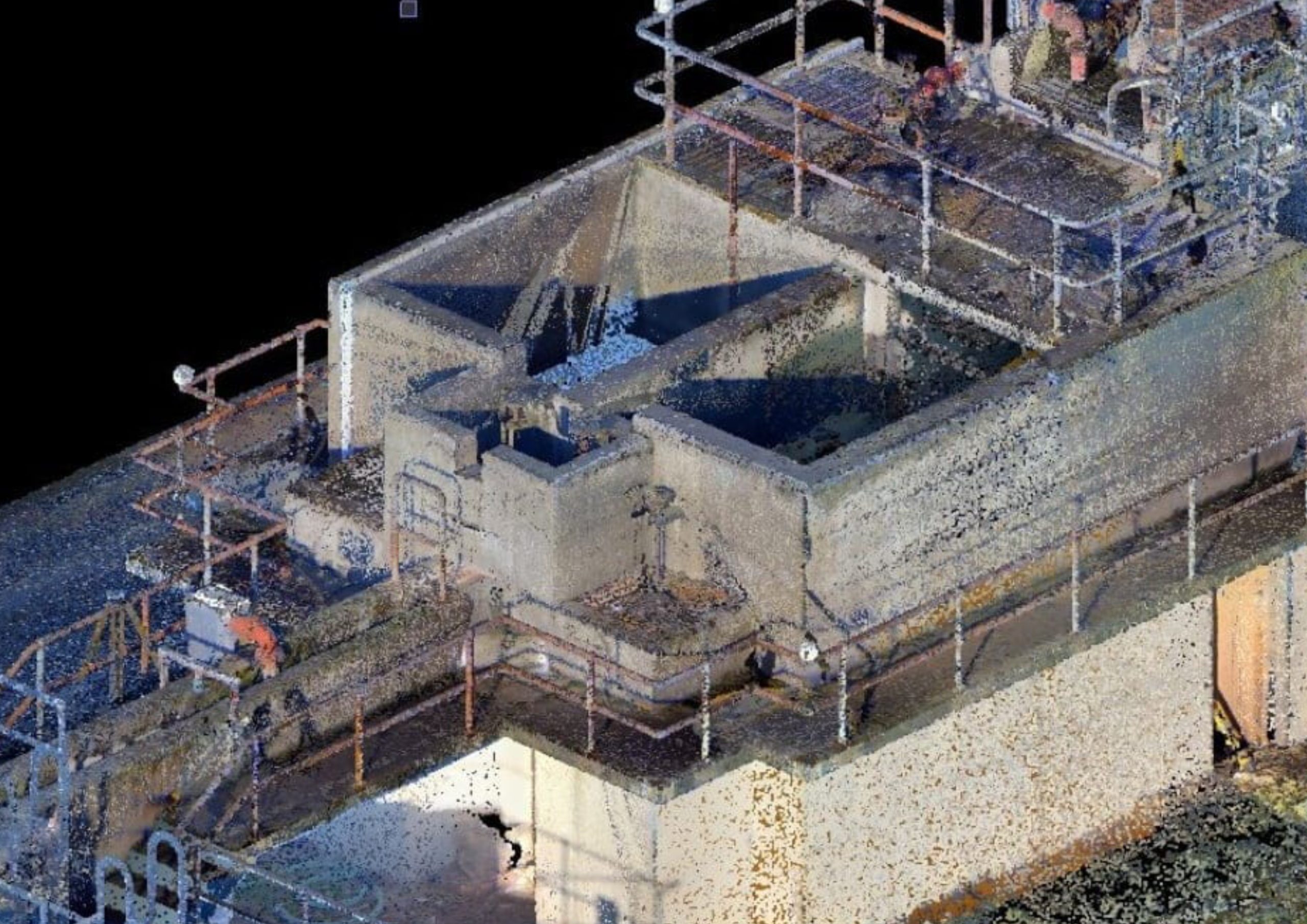
Mobile scanning — the surveyor walks through the space with the scanner, which simultaneously builds a map of the environment and tracks its position within it without requiring fixed setup points. SLAM scanning is faster in large, complex interior spaces but produces a lower-density point cloud than TLS. Ideal for rapid capture of industrial facilities, large floor areas and spaces where setting up a TLS instrument at multiple positions would be impractical. Best for: industrial facilities, large interior spaces, constrained or operationally active environments, rapid capture where TLS setup time is prohibitive.
UAV LiDAR (Drone Laser Scanning)
If you are not sure which method is right for your project, tell us what the data needs to support and we will advise. Getting the method right at the start saves time, reduces cost and produces better data.
What we capture and what you receive
A laser scan captures the complete three-dimensional geometry of everything within the scanner’s field of view — millions of measured data points forming a dense, accurate point cloud that represents the physical world as it existed at the moment of survey. Unlike conventional survey, which captures discrete features and measurements, laser scanning captures everything — including the features you did not know to ask for and the dimensions you will need six months into the design process.
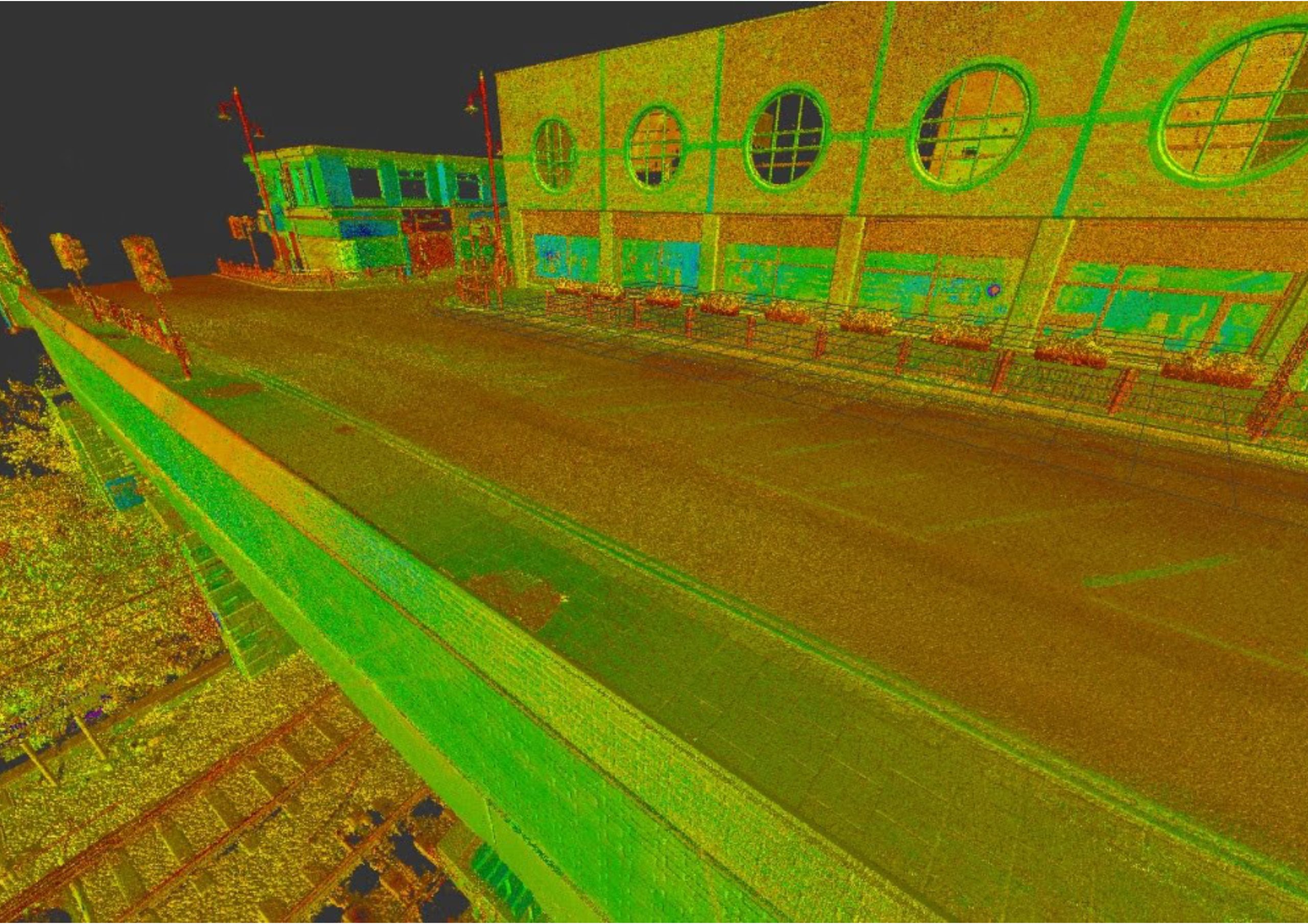
Dense 3D point cloud
The primary output of every laser scan. Delivered in RCP, RCS, E57 or LAS format depending on your workflow requirements. Every point positioned in three-dimensional space, georeferenced to OS National Grid.
Colourised point cloud
Where camera integration is used alongside the scan, the point cloud is colourised from the photography — producing a photorealistic 3D record of the site that can be viewed and measured in the office.
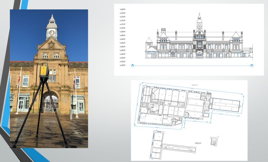
2D CAD drawings
Floor plans, elevations, sections and roof layouts extracted from the point cloud and produced in AutoCAD DWG or DXF to the scale and accuracy your design stage requires.
BIM and Revit models
3D models produced in-house from scan data to the LOD specified in your Employer's Information Requirements. Ready to use in your design environment without reprocessing.
PDF plans and elevations
For planning submissions, heritage records and project documentation.
3D mesh models and surfaces
For heritage conservation, structural assessment and visualisation applications.
Orthorectified imagery
Photography rectified to the scan geometry and overlaid on elevations, enhancing visualisation of surface detail for heritage recording, façade condition surveys and planning submissions.
Why Laser Scanning Matters
Why Laser Scanning Matters
Laser scanning revolutionises survey data collection by offering:
Capture complex environments far faster than traditional methods.
Millimetre-level precision for detailed modelling and analysis.
Data captured from a distance reduces need for access to hazardous areas.
Hard-to-measure features are recorded in dense 3D point clouds.
Who commissions laser scanning from us
Architects and project managers
Measured building surveys and BIM models for refurbishment, extension, listed building alteration and new build projects at every RIBA stage. We deliver in the format your practice works in, structured for immediate use in Revit or AutoCAD.
Heritage bodies and conservation architects
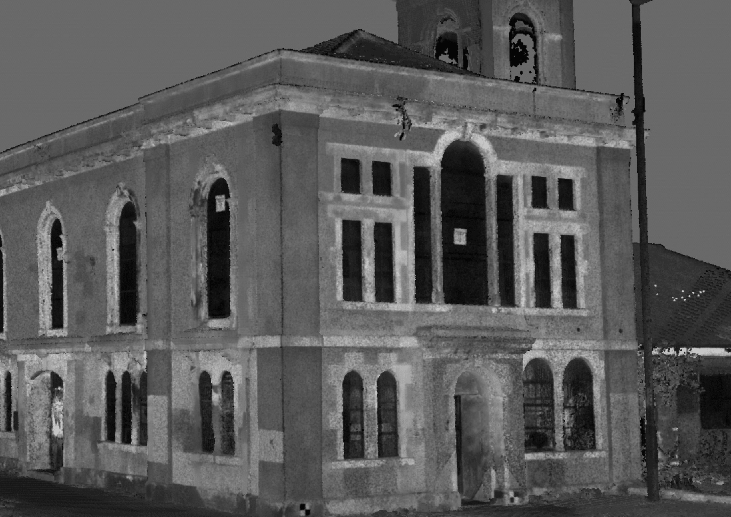
Detailed 3D records of Grade I and Grade II listed structures, scheduled monuments, historic buildings and complex historic fabric. The scan captures everything — including the geometry, the condition and the detail that tape survey would miss.
Industrial facility managers
As-existing records of process plant, industrial buildings and complex engineering environments for retrofit, expansion, maintenance planning and regulatory compliance. SLAM scanning for large internal spaces. TLS for detailed geometric capture of plant and equipment.
Civil engineers and structural engineers
Structural condition surveys, as-built records and BIM models for infrastructure, bridges, tunnels and complex structural environments where conventional survey is impractical.
Construction contractors
As-built verification at programme stages, clash detection between existing structure and proposed works, and progress records on complex refurbishment programmes.
Local authorities and public sector estates
Building condition surveys, measured building records and BIM models for public buildings, civic structures, schools, healthcare facilities and emergency services estates.
Security-critical sites
Land Surveying Services
Laser Scanning Surveys for Your Sector
our laser Scanning case studies
Darwen Market Hall — Surveying for Regeneration
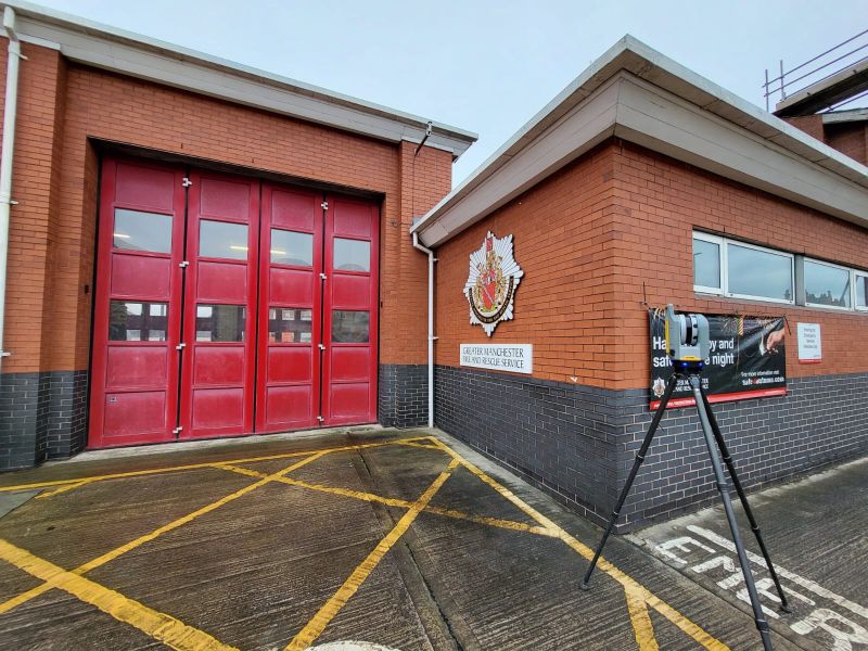
Eccles Fire Station Refurbishment
Laser scanning and measured building survey at a live fire station — coordinated around operational shifts, emergency drills and vehicle movements. The scan captured complete internal and external building geometry without disrupting a single emergency callout. The data gave the architectural team a complete, accurate record of the existing building before refurbishment design began — captured in a single mobilisation, without any programme impact on the station.
Our Services
How Laser Scanning Integrates With Other Services
How Laser Scanning Integrates With Other Services
Topographical Surveys
OS-controlled accurate, efficient and cost effective surveys for highways, civils and development. Cad and BIM-ready output.
PAS 128 utility mapping
Providing the location of underground services in 2D or 3D through qualified utility mapping surveys, using advanced GPR and Electromagnetic Location.
Measured building survey
Delivering accurate as-built information that supports design, refurbishment, planning and construction with the latest technology. Producing reliable drawings and digital models.
Laser Scanning
3D laser scanners capture millions of points per second, creating a point cloud which enables the finer details and the physical site to be viewed remotely.
Mobile mapping
For highway engineers, infrastructure managers, local authorities and contractors working on live road schemes, mobile mapping is now the standard for corridor surveys.
3D Machine control
With decades of supporting major earthworks contractors and large-scale infrastructure schemes, we provide reliable machine control across Lancashire and the wider UK.
Setting out engineers
With strong, long-standing relationships across the civil engineering and construction sector, we supply skilled professionals who keep your projects accurate, efficient and on programme.
bathymetric surveys & river surveys
Using modern technology, we capture detailed underwater and river channel information safely and efficiently – delivering reliable data you can trust.
Stockpile surveys & volumetric analysis
Whether a one-off stockpile measurement or regular monitoring, we deliver reliable, repeatable data tailored to your project using advanced technology.
Control Network Installation
Delivering robust and precise site control systems to support every stage of construction in developments, infrastructure schemes or major earthworks.
aerial & drone surveys
CAA-approved drone operations for aerial mapping, photogrammetry and volumetric analysis, providing a comprehensive view of terrain, structures and landscapes.
3D BIM Modelling
Whether you require an as-built Revit model, federated coordination model or detailed digital twin, our team delivers high quality, design-ready outputs.
survey equipment hire
We offer a vast range of surveying and engineering equipment for hire and will always try to beat a comparable quote. Discover the fleet.
monitoring
Providing reliable monitoring surveys across the UK, delivering precise data that supports risk management, compliance and informed decision making throughout a project lifecycle.
Virtual Tour 3D
An immersive experience which instantly transports your clients to your business, guiding them through your space and creating a seamless experience.
Impermeable area surveys
We deliver georeferenced impermeable area data that drainage engineers and planning consultants can work from directly.
CCTV & Drainage surveys
Acoustic & Noise Assessments
We deliver acoustic and noise assessments, supporting planning applications, discharge of conditions and Environmental Impact Assessments.
Topographical Surveys
PAS 128 utility mapping
Laser Scanning
Mobile mapping
Setting out engineers
bathymetric surveys & river surveys
Control Network Installation
aerial & drone surveys
survey equipment hire
monitoring
Impermeable area surveys
CCTV & Drainage surveys
3D Machine control
Acoustic & Noise Assessments
Stockpile surveys & volumetric analysis
3D BIM Modelling
3D BIM Modelling
Virtual Tour 3D
Why choose site surveying services for laser scanning surveys
On site. On spec. On time.
Three methods. Right one chosen for your site.
TLS for maximum detail. SLAM for large interiors. UAV LiDAR for aerial and external coverage. We advise on the right methodology for your environment — not the one we are most comfortable deploying.
Sub-5mm accuracy. As standard.
Trimble X7 and Leica instrumentation. Sub-5mm accuracy on TLS surveys. Documented in the methodology statement delivered with every commission.
Live sites. Confined spaces. Heritage buildings.
In spaces too small for a surveyor with a tape. In live operational environments without stopping the programme. We have done it at HMP Manchester, Eccles Fire Station and BAE Systems.
Point cloud, CAD and BIM from one site visit.
The scan provides all three. Our team processes it in-house. No third-party modellers. No outsourcing. One mobilisation, three deliverable types, no additional visits.
Frequently Asked Questions
Frequently Asked Questions
What is 3D laser scanning and how does it work?
3D laser scanning uses pulsed laser technology to rapidly measure millions of precise spatial points. The scanner emits a laser pulse, measures the time it takes to return after hitting a surface, and calculates the exact distance and position of that surface point. Repeated millions of times per second across a 360° field of view, this process builds a dense three-dimensional point cloud representing the complete geometry of everything within the scanner’s range. The point cloud can then be processed to produce floor plans, elevations, BIM models and any other deliverable the project requires.
What is a point cloud?
A point cloud is the raw output of a laser scan — millions of measured data points, each with an X, Y and Z coordinate, collectively representing the three-dimensional geometry of the scanned environment. In a design or engineering workflow, point clouds can be imported into Revit, AutoCAD, Rhino, SketchUp and most major design platforms, allowing the team to view and measure the existing building or site in 3D without returning to site. Point cloud data is particularly valuable for complex geometry, heritage buildings and refurbishment projects where the existing fabric is irregular.
What is the difference between TLS, SLAM and UAV LiDAR?
TLS (Terrestrial Laser Scanning) uses a stationary instrument on a tripod — highest accuracy, highest point density, best for measured building surveys, heritage recording and BIM delivery. SLAM (Simultaneous Localisation and Mapping) uses a mobile scanner carried by the surveyor — faster in large interior spaces but lower point density than TLS, best for industrial facilities and rapid capture. UAV LiDAR uses a drone-mounted sensor — best for large outdoor areas, vegetation penetration, roof and upper façade capture and terrain survey where ground access is impractical. We advise on the right method for your project at the time of scoping.
How accurate is laser scanning?
TLS scanning typically achieves 3–6mm accuracy at close to medium range, making it suitable for all measured building survey, heritage recording and BIM applications. SLAM scanning achieves 10–20mm accuracy depending on the environment and the complexity of the space. UAV LiDAR achieves 50–100mm accuracy on terrain surveys with good ground control. For projects where higher accuracy is required, we will confirm the achievable accuracy for your specific environment and deliverable requirement at the time of scoping.
Can you scan occupied buildings and live sites?
Yes. We are experienced in scanning occupied buildings, live operational environments and sites with active programmes running alongside the survey. Our method statements are tailored to the site conditions — we work around shift patterns, operational schedules and access restrictions to capture the data the project needs without disrupting the people and operations around us. Eccles Fire Station and HMP Manchester are direct examples of this capability in demanding operational environments.
What file formats do you deliver point cloud data in?
We deliver point cloud data in RCP, RCS, E57 and LAS format as standard — covering Autodesk, Leica, Trimble and open-standard workflows. If your project requires a specific format for a particular software platform, confirm this at the time of instruction and we will build it into the deliverable specification.
Can you deliver a Revit model from scan data?
Yes. We produce Revit models in-house from laser scan data — structured to your EIR, at the LOD your project specifies, in the Revit version your practice uses. All modelling is completed by our directly employed team. The model is checked against the point cloud before delivery — you receive a model that accurately represents what the scan captured, not a model produced by a third party from data they were not involved in collecting.
How long does a laser scanning survey take?
This depends on the size, complexity and access conditions of the site or building. A straightforward single-storey building can typically be captured in a few hours. A large, multi-storey building, complex industrial facility or heritage structure with many rooms and levels will take longer. We will give you a realistic programme at the time of quoting — and we will tell you if our estimated scan time requires phased access, out-of-hours working or multiple visit days.
Do you scan heritage and listed buildings?
Yes — including in operationally sensitive and restricted access environments. Heritage buildings are some of the most compelling laser scanning applications — the scan captures the full complexity of historic fabric, irregular geometry and fine detail that conventional tape survey cannot reliably record. We have scanned historic churches, listed market halls, heritage buildings in Lancashire and complex conservation environments across the North West. Our methodology for heritage survey is always agreed with the client before site visit.
Is laser scanning suitable for dark or confined spaces?
Yes. Laser scanners do not require visible light to operate — they emit their own laser pulse and measure the return, making them effective in complete darkness. We use portable lighting units where camera colourisation is required alongside the scan. For confined spaces, SLAM scanning allows the surveyor to move through restricted areas that would be impractical to scan with a stationary TLS instrument.
What areas do you cover?
Our head office is in Clitheroe, Lancashire, with offices in Matlock, Newcastle and Bristol. We deliver laser scanning across the North West, North East, Midlands and South West as primary territories, and nationally. All work is carried out by our directly employed team. No project is too far if the programme requires it.