


 Leeds
Leeds Doncaster
 Sheffield
 Bradford
 Hull
Hull Halifax
 Sunderland
 Newcastle
 Middlesborough
 Yorkshire Moors
 Teesside
 Cumbria
 Harrogate
 York
York Yorkshire Dales
 Northumberland
 Goole
Goole Carlisle
 Keswick
 Kendal
 Barrow-in-Furness
 Lancaster
 Blackpool
 Morecambe
 Southport
 Liverpool
 Wigan
Wigan Manchester
 Blackburn
 Burnley
 Forest of Bowland
 Oldham
 Chester
 Stockport
 Peak District
 Skipton
 Crewe
Crewe Rotherham
 Stoke
Stoke Driffield
Surveying Services North West
Site Surveying Services in the Forest of Bowland, Lancashire
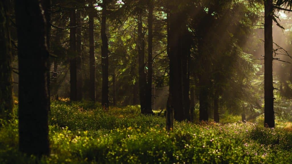
The Forest of Bowland is one of Lancashire’s — and the North West’s — most treasured landscapes. Stretching across some 800 square kilometres of rolling moorland, deep river valleys, ancient woodland, and wild open fells between the Yorkshire Dales and Pendle Hill, Bowland is a place of extraordinary natural beauty, rich biodiversity, and profound rural character. The rivers Hodder, Ribble, and Lune flow through its heart. Red kites soar above its uplands. And somewhere near its southern edge, in the market town of Clitheroe, sits the headquarters of Site Surveying Services.
The Forest of Bowland is our home landscape. We survey here regularly — and we understand its terrain, its access challenges, its environmental sensitivities, and its planning context in a way that only comes from being truly local. From telecommunications infrastructure surveys deep in Gisburn Forest to rural topographic work across the AONB’s river valleys and moorland edges, our teams are as comfortable in Bowland’s landscape as anywhere we work. Whether you’re delivering telecoms infrastructure, planning a rural development, managing a country estate, or working on environmental or flood risk projects along one of Bowland’s rivers, we are the natural first call for professional survey services in this extraordinary landscape.
Our Surveying Services in the Forest of Bowland
We offer a full range of professional surveying services to clients working within and around the Forest of Bowland National Landscape:
Topographic Surveys Forest of Bowland
detailed land and site surveys across Bowland's varied moorland, river valley, and woodland terrain, for infrastructure planning, development, and estate management
Linear Infrastructure Surveys Forest of Bowland
GPS-controlled total station surveys of roads, tracks, and cable routes across remote and semi-remote rural locations
River & Watercourse Surveys Forest of Bowland
cross-sections, longitudinal profiles, and flood risk topographic surveys along the Hodder, Ribble, Lune, and their tributaries
UAV / Drone Surveys Forest of Bowland
aerial data capture across Bowland's upland and wooded terrain, ideal for large rural sites, watercourses, and difficult-access locations
Sectors We Serve in the Forest of Bowland
Our Forest of Bowland project experience spans the full range of rural, infrastructure, and environmental activity across the National Landscape:
Telecoms & Digital Infrastructure Forest of Bowland
topographic surveys for mast installation, cable routing, and telecommunications infrastructure in remote and semi-remote rural locations
Environmental & Ecological Forest of Bowland
survey support for flood risk, river management, and ecological projects along Bowland's river corridors
Rural Estates & Landowners Forest of Bowland
estate surveys, boundary assessments, and land management surveys for private landowners across the Bowland area
Forestry & Woodland Forest of Bowland
surveys within Bowland's managed forests, including Gisburn Forest, for infrastructure, access, and management purposes
Agriculture & Rural Development Forest of Bowland
surveys for farm buildings, agricultural land, and rural development proposals within the National Landscape
Infrastructure & Utilities Forest of Bowland
linear surveys for roads, utilities, and cable routing across Bowland's road and track network
Case Study: Gisburn Forest Telecommunications Survey — Clarke Telecom
Case Studies & Project Highlights
Active travel scheme
A commission that sits perfectly at the intersection of our home landscape and our technical capability — a comprehensive topographic survey in Gisburn Forest for Clarke Telecom, supporting the installation of new telecommunications masts near Stocks Reservoir, Clitheroe.
The brief: survey approximately two miles of road where electric cables would be installed to connect to the new masts. The route survey was essential for planning the optimal cable installation path and ensuring the successful implementation of the new telecoms infrastructure across this remote rural environment.
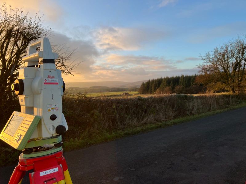
Survey methodology
To achieve the high level of accuracy required across a two-mile linear route in a challenging rural environment, we established GPS control points across the entire length of the site — creating a reliable spatial framework for integrating Total Station (TS) data throughout the survey. By traversing the full length of the road, our team meticulously measured all relevant road details and widths, extending survey data to the boundaries on either side of the road corridor. The survey captured precise information on road gradients, surface conditions, and all existing features that could impact the cable installation — from drainage channels and verge conditions to existing infrastructure and natural obstacles.
GPS and Total Station integration
The GPS control points provided the accurate, consistent framework needed to integrate the Total Station data seamlessly across the full route length, ensuring high accuracy and spatial consistency throughout the survey dataset. This dual-instrument approach — GPS for control, Total Station for detail — is particularly well suited to linear infrastructure surveys in rural environments where single-point control would not provide sufficient accuracy across the full route length.
The resulting detailed topographic map of the road and its surroundings gave Clarke Telecom’s engineering team the precise spatial data they needed to plan the cable route efficiently, safely, and without disrupting the existing road infrastructure or the surrounding Gisburn Forest environment. A five-day on-site programme with two days of office processing — delivered efficiently in one of Lancashire’s most remote and beautiful landscapes.
Client details
Clarke Telecom
service provided
Topographical Survey
Project timeline
5 days on site / approx. 2 days in the office
The Forest of Bowland's Planning & Management Framework
The Forest of Bowland's Planning & Management Framework
The Forest of Bowland is designated as a National Landscape — formerly known as an Area of Outstanding Natural Beauty (AONB), redesignated under the Levelling-up and Regeneration Act 2023. The National Landscape designation provides the highest level of protection for the area’s natural beauty, and all planning and development within it must give great weight to conserving and enhancing the landscape’s special qualities. Unlike a National Park, the Forest of Bowland does not have its own planning authority. Planning decisions for land within the National Landscape are made by the relevant local planning authority — primarily Ribble Valley Borough Council, Lancaster City Council, Wyre Borough Council, and parts of North Yorkshire and Craven — depending on which administrative area a particular site falls within.
The Forest of Bowland is managed and promoted by the Forest of Bowland National Landscape Partnership, which works collaboratively with local authorities, landowners, conservation organisations, and community groups to ensure the sustainable management and enhancement of the area’s natural and cultural heritage. The AONB Management Plan remains the key strategic document guiding the stewardship of the landscape.
Why Choose Site Surveying Services in the Forest of Bowland?
Why Choose Site Surveying Services in the Forest of Bowland?
We are local
based in Clitheroe, on the southern edge of the Forest of Bowland, we know this landscape intimately and can mobilise to any point within it faster than any out-of-area firm
Rural and linear infrastructure specialists
our Gisburn Forest commission demonstrates our capability on remote rural surveys requiring GPS control and Total Station traverse across extended linear routes
Telecoms and utilities experience
experienced in supporting telecoms infrastructure programmes in rural and semi-remote locations where accurate route surveys are critical
River and watercourse expertise
the Hodder, Ribble, and Lune are rivers we survey regularly; our team understands the access, environmental, and tidal considerations that come with watercourse survey work in this landscape
AONB/National Landscape sensitivity
we understand the specific planning and environmental context of working within a protected landscape and deliver survey work that respects and supports that framework
UAV capability for remote terrain
our drone survey capability is particularly valuable across Bowland's upland and wooded terrain where ground access is restricted
Frequently Asked Questions
Frequently Asked Questions
Do you carry out surveys in the Forest of Bowland National Landscape?
Yes — and it’s effectively our home survey territory. Based in Clitheroe, we are ideally located for any project within the Forest of Bowland and have delivered surveys across the landscape including in Gisburn Forest near Stocks Reservoir. We understand the access, environmental, and planning context of the National Landscape from direct experience.
What is the difference between the Forest of Bowland being an AONB and a National Landscape?
The Forest of Bowland was redesignated from an Area of Outstanding Natural Beauty (AONB) to a National Landscape under the Levelling-up and Regeneration Act 2023. The level of protection for the landscape’s natural beauty is equivalent, but the new National Landscape designation brings updated governance arrangements and a clearer national framework. For planning purposes, great weight must still be given to conserving and enhancing the landscape’s special qualities in all development decisions.
Can you carry out topographic surveys for telecoms and utilities infrastructure in Bowland?
Yes. Our Gisburn Forest commission for Clarke Telecom is a strong example — a two-mile linear topographic survey using GPS control and Total Station traverse to produce the accurate route data needed for cable installation planning. We are experienced in linear infrastructure surveys across rural and remote environments.
Do you carry out river surveys along the Hodder, Ribble, and Lune?
Yes. River section surveys, longitudinal profiles, and flood risk topographic surveys along the rivers that flow through the Forest of Bowland are part of our regular local workload. We support hydraulic modelling, flood risk assessments, and environmental management programmes across the Bowland river network.