

Land and engineering surveyors based in Lancashire
3D Machine Control Services
3D Machine Control Lancashire and the north west
Machine Control Support for Earthworks & Construction Projects Across the UK
Machine Control Support for Earthworks & Construction Projects Across the UK
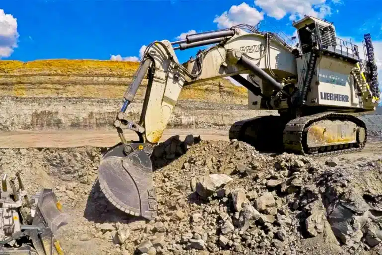
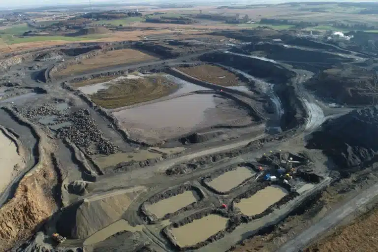
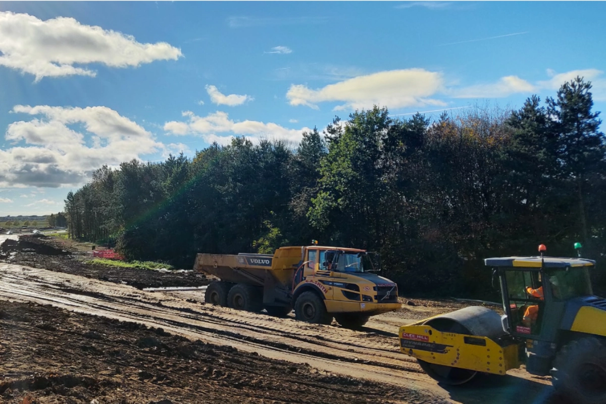
Machine control removes guesswork from earthworks. When excavators, dozers, graders and pavers are guided by precise 3D digital models rather than traditional pegs and boning rods, accuracy improves, rework reduces, setting-out time drops and the programme moves faster. The investment in a well-set-up machine control system pays for itself quickly on any significant earthworks scheme — and the cost of a poorly calibrated one is measured in abortive earthworks that cannot be recovered.
Site Surveying Services has been delivering 3D machine control support across Lancashire, the North West and nationally since the earliest adoption of these systems by UK construction contractors. Our machine control capability grew directly from the setting-out and digital survey work we have always delivered — we understood the data requirements before the technology arrived. We work with Trimble, Topcon and Leica systems, and we have delivered machine control support on major earthworks programmes, highway schemes, slipform paving contracts and airport infrastructure at Heathrow, Gatwick and Stansted.
The difference between a machine control provider that understands survey and one that does not becomes apparent at calibration. If the coordinate system is wrong, the entire site is wrong — and everything built from it is wrong. Getting it right at the start is the only thing that matters.
What Is 3D Machine Control?
3D machine control is a technology used to guide plant machinery such as dozers, excavators, graders and pavers, using GPS and digital design models. By installing a 2D or 3D model into the machine control system, operators can work directly to design without constant setting out, reducing downtime and improving productivity. Machine control supports:
Benefits of 3D Machine Control
Benefits of 3D Machine Control
Commissioning professional machine control support provides major advantages:
Reduced setting-out time
Operators work directly to the design model without a surveyor pegging every level and line. Earthworks can proceed continuously without waiting for the setting-out team to catch up with the plant.
Improved earthworks accuracy
GPS-guided plant consistently achieves tighter tolerances than conventional peg-and-boning-rod methods. Formation levels are more accurate, surface finish is better and re-cuts are significantly reduced.
Reduced rework and waste
When plant cuts and fills to the correct design level first time, there is no over-excavation to correct and no imported material needed to make up levels that were cut too deep. On large earthworks schemes this is a significant commercial saving.
Faster programme delivery
The combination of reduced setting-out time, better accuracy and less rework consistently accelerates earthworks programmes. On time-critical schemes, machine control is one of the most effective programme tools available.
Real-time design compliance
The operator's in-cab display shows the relationship between the bucket or blade and the design surface in real time. Deviation from design is visible to the operator before it becomes a problem, not after.
Improved on-site safety
Fewer surveyors working around moving plant. Setting-out pegs that present trip hazards are replaced by in-cab guidance. The separation between survey personnel and heavy plant is increased.
The Machine Control Services We Provide.
The Machine Control Services We Provide.
3D model creation from design data
The starting point for any machine control programme. We take design information in 2D or 3D format — whether that is an AutoCAD DWG, a 12d model, a Civil 3D surface or a PDF of design drawings — and convert it into a machine-ready model formatted for installation on Trimble, Topcon or Leica systems.
Models we produce include: earthworks surfaces and formation levels, road and highway alignments and cross-sections, paving and slipform control models, drainage formation models, and complex multi-surface earthworks with cut and fill boundaries.
The model quality determines the accuracy of every earthworks operation that follows from it. We check every model against the design data before it leaves our team.
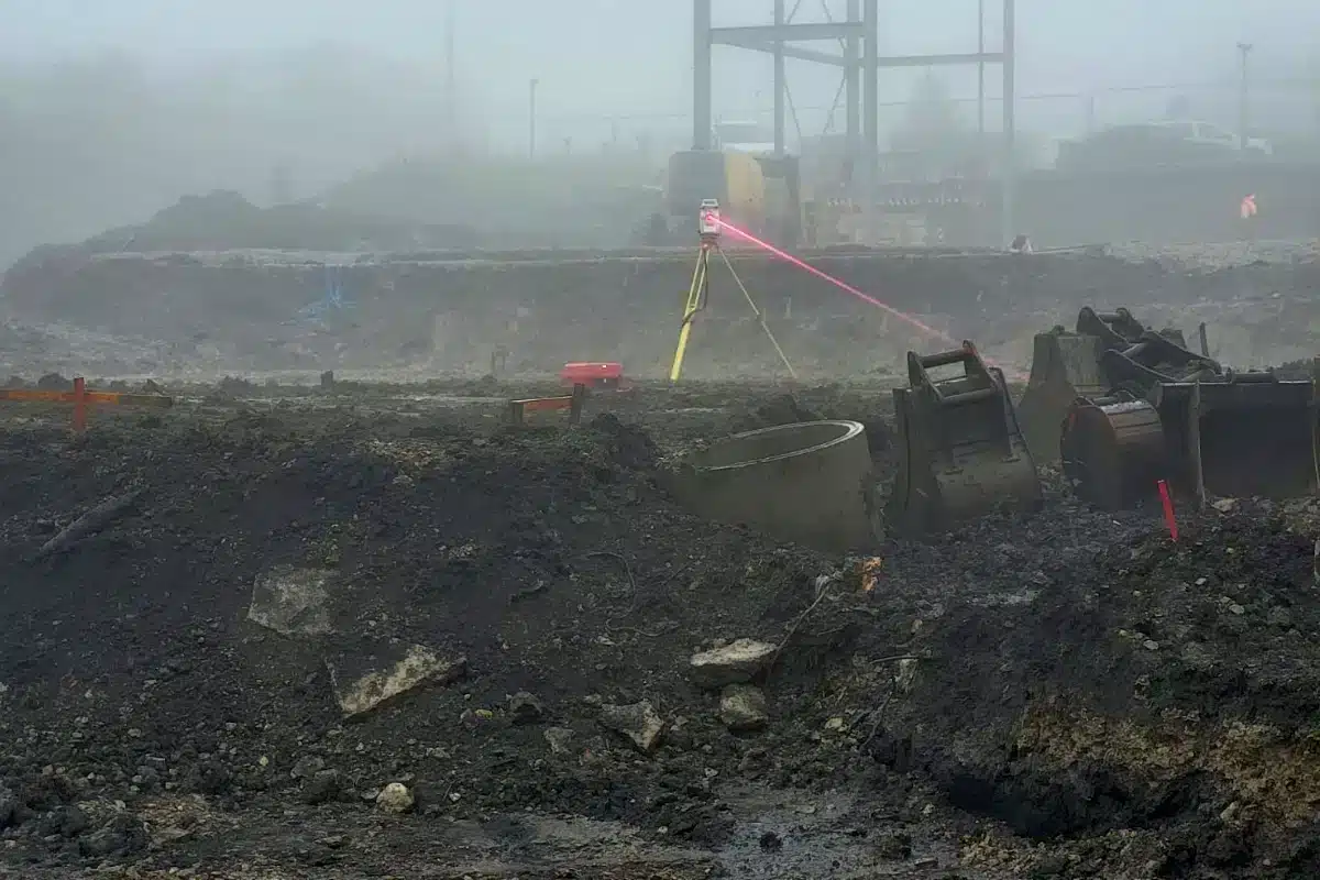
Base station hire and setup
Site calibration and control setup
The coordinate system of the machine control model must match the coordinate system of the site — and that must be verified, not assumed. We carry out site calibrations that tie the machine control system to the site control network established during the pre-construction survey, checking calibration points across the site to confirm consistency and identifying any discrepancies before earthworks begin.
If we have carried out the pre-construction topographic survey or setting-out on the scheme, we already understand the site coordinate system and the calibration is straightforward. If we are coming onto a scheme where another surveyor set up the control, we verify independently before confirming the calibration is correct.

Laser systems — hire and machine setup
Dual-grade laser hire and machine setup for earthworks and construction projects where a laser-guided approach is specified. We provide the laser system, install it on the machine, calibrate it and confirm it is operating correctly. Ongoing site support available throughout the programme.
UTS systems — hire and setup
For projects requiring the highest levels of positioning accuracy, we offer Universal Total Station (UTS) system hire and setup. UTS systems use a robotic total station rather than GPS to guide the machine — appropriate where GPS signal is unreliable (under bridges, in cuttings, near tall structures), where the tolerance requirements are tighter than GPS can consistently achieve, or where the work involves slipform paving or other high-precision paving operations.
Applications include: high-precision paving, airport runway and taxiway schemes, tight-tolerance infrastructure works and any application where GPS cannot maintain the accuracy the programme requires.

Land Surveying Services
3D Machine Control for Your Sector
Clients and Programmes We Have Supported
Clients and Programmes We Have Supported
CA Blackwell
Long-standing relationship delivering machine control model creation and calibration support on major earthworks programmes. CA Blackwell are one of the UK's leading earthworks and civil engineering contractors and their machine control requirements reflect the scale and complexity of the schemes they deliver.
Priors
Machine control support on civil engineering and earthworks programmes, model creation and base station setup.
Slipform paving contractors
UTS-guided slipform paving operations requiring the highest level of positional accuracy available. GPS is not sufficient for slipform paving — UTS systems are the standard, and setting them up correctly is a specialist task.
Airport infrastructure — Heathrow, Gatwick and Stansted
Machine control support on airport infrastructure schemes at three of the UK's major airports. Airside working, tight tolerances, complex coordinate systems and zero tolerance for error. These are the most demanding machine control environments we work in, and the experience of delivering correctly in these environments is reflected in everything we do on earthworks schemes across Lancashire and the North West.
our 3d machine control case studies
Base Station Setup and 3D Machine Control — East Yorkshire
Machine control setup for a long-standing earthworks client on a scheme in East Yorkshire. Calibration in place from previous visits, base station verified against established control points across the site, designs loaded and confirmed on the machines before earthworks commenced. A straightforward commission made straightforward by the relationship and the established site coordinate system — which is exactly how it should work.

Slipform Paving — UTS Machine Control
UTS system hire and setup for a slipform paving operation — robotic total station guidance rather than GPS, achieving the sub-10mm positional accuracy that slipform paving requires. The system was calibrated against the pavement alignment and cross-section design before a single metre of concrete was laid. The paving proceeded without incident.

Our Services
How 3D Machine Control Integrates With Other Services
How 3D Machine Control Integrates With Other Services
Topographical Surveys
OS-controlled accurate, efficient and cost effective surveys for highways, civils and development. Cad and BIM-ready output.
PAS 128 utility mapping
Providing the location of underground services in 2D or 3D through qualified utility mapping surveys, using advanced GPR and Electromagnetic Location.
Measured building survey
Delivering accurate as-built information that supports design, refurbishment, planning and construction with the latest technology. Producing reliable drawings and digital models.
Laser Scanning
3D laser scanners capture millions of points per second, creating a point cloud which enables the finer details and the physical site to be viewed remotely.
Mobile mapping
For highway engineers, infrastructure managers, local authorities and contractors working on live road schemes, mobile mapping is now the standard for corridor surveys.
3D Machine control
With decades of supporting major earthworks contractors and large-scale infrastructure schemes, we provide reliable machine control across Lancashire and the wider UK.
Setting out engineers
With strong, long-standing relationships across the civil engineering and construction sector, we supply skilled professionals who keep your projects accurate, efficient and on programme.
bathymetric surveys & river surveys
Using modern technology, we capture detailed underwater and river channel information safely and efficiently – delivering reliable data you can trust.
Stockpile surveys & volumetric analysis
Whether a one-off stockpile measurement or regular monitoring, we deliver reliable, repeatable data tailored to your project using advanced technology.
Control Network Installation
Delivering robust and precise site control systems to support every stage of construction in developments, infrastructure schemes or major earthworks.
aerial & drone surveys
CAA-approved drone operations for aerial mapping, photogrammetry and volumetric analysis, providing a comprehensive view of terrain, structures and landscapes.
3D BIM Modelling
Whether you require an as-built Revit model, federated coordination model or detailed digital twin, our team delivers high quality, design-ready outputs.
survey equipment hire
We offer a vast range of surveying and engineering equipment for hire and will always try to beat a comparable quote. Discover the fleet.
monitoring
Providing reliable monitoring surveys across the UK, delivering precise data that supports risk management, compliance and informed decision making throughout a project lifecycle.
Virtual Tour 3D
An immersive experience which instantly transports your clients to your business, guiding them through your space and creating a seamless experience.
Impermeable area surveys
We deliver georeferenced impermeable area data that drainage engineers and planning consultants can work from directly.
CCTV & Drainage surveys
Acoustic & Noise Assessments
We deliver acoustic and noise assessments, supporting planning applications, discharge of conditions and Environmental Impact Assessments.
Topographical Surveys
PAS 128 utility mapping
Laser Scanning
Mobile mapping
Setting out engineers
bathymetric surveys & river surveys
Control Network Installation
aerial & drone surveys
survey equipment hire
monitoring
Impermeable area surveys
CCTV & Drainage surveys
3D Machine control
Acoustic & Noise Assessments
Stockpile surveys & volumetric analysis
3D BIM Modelling
3D BIM Modelling
Virtual Tour 3D
Why Choose Site Surveying Services for 3d machine control?
On site. On spec. On time.
Model created from your engineer's files. Checked before loading.
We extract the design model, format it for your guidance system and check it for consistency before a single machine is calibrated. Conflicts identified before earthworks begin — not after the formation is wrong. We confirm compatibility at instruction.
On-site support throughout the earthworks programme.
Recalibration when the base station moves. Design updates when the engineer revises the model. Guidance system troubleshooting when the machine operator calls. Available throughout the programme — not just on commissioning day.
Combined with setting-out. One instruction.
Machine control for bulk earthworks. Our directly employed setting-out engineers for critical positions — drainage interfaces, structural foundations, formation tolerances. The combination that covers the full earthworks programme.
Frequently Asked Questions
Frequently Asked Questions
What is 3D machine control?
3D machine control is a technology that guides construction plant — excavators, dozers, graders and pavers — using GPS or total station positioning combined with a digital design model loaded into the machine’s in-cab computer. The operator’s display shows the real-time relationship between the machine’s cutting edge or blade and the design surface, allowing them to work to formation level without conventional surveying pegs or boning rods. The result is faster, more accurate earthworks with less rework and less surveying time spent around moving plant.
What is the difference between GPS machine control and UTS machine control?
GPS machine control uses satellite positioning to determine the machine’s position and guide it to the design surface. It is effective across most earthworks applications and achieves typical positional accuracy of 10–30mm depending on the system, the conditions and the GNSS correction signal quality. UTS (Universal Total Station) machine control uses a robotic total station tracking a prism on the machine to determine position — achieving sub-10mm accuracy and performing reliably in environments where GPS signal is obstructed or unreliable (under structures, in cuttings, near tall buildings). UTS is the standard for slipform paving and other high-precision applications where GPS accuracy is insufficient.
What information do you need to create a machine control model?
We need the design data in digital format — typically AutoCAD DWG, Civil 3D surface files, 12d model data or PDF drawings from which we can digitise the design. The more complete the design data, the faster and more accurately we can produce the model. We also need to understand the site coordinate system so that the model aligns correctly with the machine control base station calibration. If we have carried out the topographic survey on the scheme, we already have this information.
What happens if the site calibration is wrong?
If the site calibration is wrong — meaning the machine control coordinate system does not correctly match the site control network — everything the plant does is wrong by the calibration error. Excavation that appears to be at the correct design level is not. Earthworks that appear to be in the correct position are not. This error compounds through every subsequent construction activity built on top of it. We verify calibration against multiple check points across the site before any plant begins. A failed calibration check is identified and corrected at setup — not discovered when the earthworks are finished.
Which machine control systems do you support?
We work with Trimble, Topcon and Leica machine control systems — the three primary platforms used across UK construction and earthworks. Our team understands the model formats, calibration procedures and base station requirements for each system. If your plant is running a less common system, tell us at the time of enquiry and we will confirm compatibility.
Can you create machine control models from 2D drawings?
Yes. Not all design information arrives as 3D surface data. Where design drawings are in 2D — plan and section format — we digitise the design and build the 3D surface from the drawing information. This is more time-consuming than working from 3D design data and the model quality is dependent on the completeness and accuracy of the 2D drawings, but it is a service we provide regularly on schemes where the design has not been produced in a 3D environment.
Do you provide on-site support during the earthworks programme?
Yes. For long-running earthworks programmes, ongoing site support is available — recalibrating the base station when it is moved, updating models when the design changes, checking calibration at the start of each working week and troubleshooting system issues. The frequency of support visits depends on the programme and the complexity of the scheme. We agree the support schedule at the time of instruction.
Can machine control replace setting-out engineers entirely?
No — and it should not. Machine control guides bulk earthworks efficiently, but it does not replace the verification function of a setting-out engineer. Formation levels need to be checked by a surveyor before the next programme stage proceeds. Control points need to be verified periodically. Design changes need to be reflected in updated models. And on schemes with complex geometry, tight tolerances or phased earthworks, a setting-out engineer working alongside the machine control system is always the correct approach. We provide both.
What areas do you cover?
Our head office is in Clitheroe, Lancashire, with offices in Matlock, Newcastle and Bristol. We deliver 3D machine control services across the North West, North East, Midlands and South West as primary territories, and nationally. We have delivered machine control support at Heathrow, Gatwick and Stansted — no scheme is too far or too demanding if the programme requires it.