


 Leeds
Leeds Doncaster
 Sheffield
 Bradford
 Hull
Hull Halifax
 Sunderland
 Newcastle
 Middlesborough
 Yorkshire Moors
 Teesside
 Cumbria
 Harrogate
 York
York Yorkshire Dales
 Northumberland
 Goole
Goole Carlisle
 Keswick
 Kendal
 Barrow-in-Furness
 Lancaster
 Blackpool
 Morecambe
 Southport
 Liverpool
 Wigan
Wigan Manchester
 Blackburn
 Burnley
 Forest of Bowland
 Oldham
 Chester
 Stockport
 Peak District
 Skipton
 Crewe
Crewe Rotherham
 Stoke
Stoke Driffield
Practical Guides for Contractors, Engineers & Consultants
Download Our Surveying Services Brochure.
Everything you need to understand what Site Surveying Services delivers, how we work and why the clients who trust us with their programmes keep coming back.
The brochure covers all 14 survey disciplines we deliver in-house, our full accreditation profile, key project case studies and the detail behind our approach to survey — written for Contracts Managers, Technical Directors, Engineering Managers, architects, developers and planners who need to assess a survey firm before they appoint one.
Fill in the form to receive your copy
What is in the Brochure?
Company Overview
who we are, where we are based, and how we have been delivering accurate land and geospatial survey across Lancashire, the North West and nationally since 1997.
All 14 Survey Disciplines
Equipment
the instrumentation we use across survey disciplines, from Leica total stations and CHCNAV GNSS to the CHCNAV AU20 Mobile Mapping System, CHCNAV X500 UAV and the Apache 4 unmanned surface vessel.
Team & Offices
Why Clients Choose Site Surveying Services.
We are already in it.
We are an active supplier on programmes across the North West — highways, water infrastructure, defence, housing, regeneration, industrial. When you call us, you are speaking to a firm that knows your supply chain environment, not one learning about it.
Directly employed team.
Every surveyor, site engineer and CAD technician is directly employed by Site Surveying Services. The person who takes your enquiry is the person who knows the job. No subcontractors, no gaps, no surprises.
In-house from survey to CAD.
Capture, processing and deliverable production all happen under one roof. The dataset you receive has been checked by the same team that captured it.
Fast from quote to on site.
Capture, processing and deliverable production all happen under one roof. The dataset you receive has been checked by the same team that captured it.
One point of contact.
From the first conversation to final data delivery, you deal with one team. If the scope changes, if something on site needs addressing, one call is all it takes.

Land and engineering surveyors based in lancashire, operating nationwide
What Site Surveying Services Delivers.
One Trusted Partner.
Since 1997, Site Surveying Services has delivered land and geospatial survey for some of the most demanding clients and programmes in the North West and nationally. We are Lancashire-based, directly employed, in-house across all 14 disciplines, and built around a single principle — the programme depends on the survey being right, and getting it right is our responsibility. All services delivered in-house. All directly employed. One team, one point of contact, one trusted partner.
Topographical Surveys
OS-controlled accurate, efficient and cost effective surveys for highways, civils and development. Cad and BIM-ready output.
PAS 128 utility mapping
Providing the location of underground services in 2D or 3D through qualified utility mapping surveys, using advanced GPR and Electromagnetic Location.
Measured building survey
Delivering accurate as-built information that supports design, refurbishment, planning and construction with the latest technology. Producing reliable drawings and digital models.
Laser Scanning
3D laser scanners capture millions of points per second, creating a point cloud which enables the finer details and the physical site to be viewed remotely.
Mobile mapping
For highway engineers, infrastructure managers, local authorities and contractors working on live road schemes, mobile mapping is now the standard for corridor surveys.
3D Machine control
With decades of supporting major earthworks contractors and large-scale infrastructure schemes, we provide reliable machine control across Lancashire and the wider UK.
Setting out engineers
With strong, long-standing relationships across the civil engineering and construction sector, we supply skilled professionals who keep your projects accurate, efficient and on programme.
bathymetric surveys & river surveys
Using modern technology, we capture detailed underwater and river channel information safely and efficiently – delivering reliable data you can trust.
Stockpile surveys & volumetric analysis
Whether a one-off stockpile measurement or regular monitoring, we deliver reliable, repeatable data tailored to your project using advanced technology.
Control Network Installation
Delivering robust and precise site control systems to support every stage of construction in developments, infrastructure schemes or major earthworks.
aerial & drone surveys
CAA-approved drone operations for aerial mapping, photogrammetry and volumetric analysis, providing a comprehensive view of terrain, structures and landscapes.
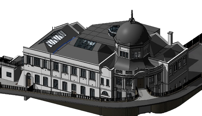
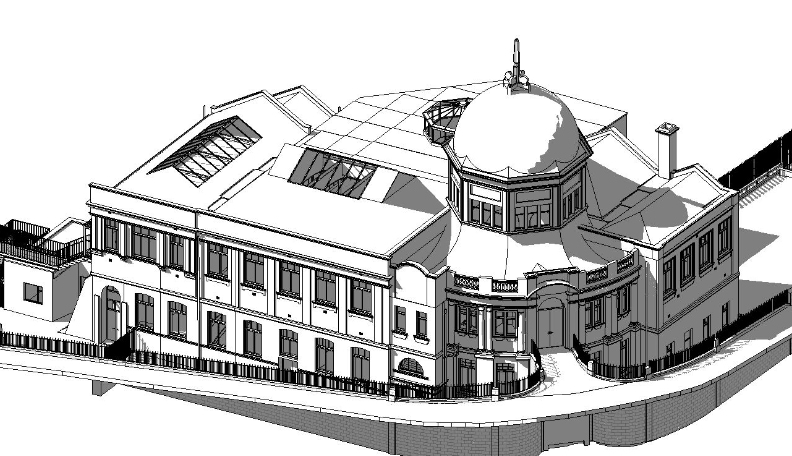
3D BIM Modelling
Whether you require an as-built Revit model, federated coordination model or detailed digital twin, our team delivers high quality, design-ready outputs.
survey equipment hire
We offer a vast range of surveying and engineering equipment for hire and will always try to beat a comparable quote. Discover the fleet.
monitoring
Providing reliable monitoring surveys across the UK, delivering precise data that supports risk management, compliance and informed decision making throughout a project lifecycle.
Virtual Tour 3D
An immersive experience which instantly transports your clients to your business, guiding them through your space and creating a seamless experience.
Impermeable area surveys
We deliver georeferenced impermeable area data that drainage engineers and planning consultants can work from directly.
CCTV & Drainage surveys
Acoustic & Noise Assessments
We deliver acoustic and noise assessments, supporting planning applications, discharge of conditions and Environmental Impact Assessments.