


 Leeds
Leeds Doncaster
 Sheffield
 Bradford
 Hull
Hull Halifax
 Sunderland
 Newcastle
 Middlesborough
 Yorkshire Moors
 Teesside
 Cumbria
 Harrogate
 York
York Yorkshire Dales
 Northumberland
 Goole
Goole Carlisle
 Keswick
 Kendal
 Barrow-in-Furness
 Lancaster
 Blackpool
 Morecambe
 Southport
 Liverpool
 Wigan
Wigan Manchester
 Blackburn
 Burnley
 Forest of Bowland
 Oldham
 Chester
 Stockport
 Peak District
 Skipton
 Crewe
Crewe Rotherham
 Stoke
Stoke Driffield
Clarity Before Construction
Demolition & Remediation Surveying
Environmental and energy projects in the North West present survey challenges that standard construction methodology cannot always address. Wetland sites where ground-based access is restricted or harmful to the habitat. River corridors where the data needed lies beneath the water surface. Wind farm and solar development sites across challenging Pennine, Lakeland and moorland terrain. Flood risk assessments where every level and drainage feature matters to the modelling. Water infrastructure upgrade schemes operating under AMP8 investment where the survey data directly underpins programme-critical design decisions.
Site Surveying Services has been delivering survey across this sector since 1997 — using UAV LiDAR, unmanned surface vessels, remote sensing and GPS-controlled ground survey to capture data safely and accurately in environments where traditional methods are impractical, too slow or potentially damaging to what is being surveyed. We are Lancashire-based, nationally capable, and our equipment is specifically chosen for the environments this sector demands.
Surveying for Demolition and Remediation Projects
Surveying for Demolition and Remediation Projects
…from unstable structures and unknown utilities to environmental hazards and access restrictions. Without accurate, up-to-date data, teams face uncertainty that can result in safety incidents, programme delays, or costly redesigns. Developers and contractors need absolute clarity before works begin – an understanding of every structural, environmental, and subsurface condition that could impact safety and success.
Why Accuracy Matters...
Accurate survey data is essential in helping to protect ecosystems and supporting sustainability goals. With reliable information, clients can:
Identify hazards early
Detecting structural weaknesses, contamination zones, or utility conflicts before mobilisation.
Plan safe access routes
Mapping clear working zones, exclusion areas, and haulage routes.
Optimise remediation design
Using detailed models to guide excavation, drainage, and earthworks strategies.
Stay compliant
Providing essential documentation for health, safety, and environmental assessments.
Support redevelopment
Delivering precise data that transitions smoothly into the design and construction phase.
Innovation in Action
Innovation in Action
These technologies reduce the need for manual inspection, enable safer planning, and ensure compliance with environmental and demolition regulations – transforming how projects are managed from first survey to final clearance.
Our Services
Topographical Surveys
OS-controlled accurate, efficient and cost effective surveys for highways, civils and development. Cad and BIM-ready output.
PAS 128 utility mapping
Providing the location of underground services in 2D or 3D through qualified utility mapping surveys, using advanced GPR and Electromagnetic Location.
Measured building survey
Delivering accurate as-built information that supports design, refurbishment, planning and construction with the latest technology. Producing reliable drawings and digital models.
Laser Scanning
3D laser scanners capture millions of points per second, creating a point cloud which enables the finer details and the physical site to be viewed remotely.
Mobile mapping
For highway engineers, infrastructure managers, local authorities and contractors working on live road schemes, mobile mapping is now the standard for corridor surveys.
3D Machine control
With decades of supporting major earthworks contractors and large-scale infrastructure schemes, we provide reliable machine control across Lancashire and the wider UK.
Setting out engineers
With strong, long-standing relationships across the civil engineering and construction sector, we supply skilled professionals who keep your projects accurate, efficient and on programme.
bathymetric surveys & river surveys
Using modern technology, we capture detailed underwater and river channel information safely and efficiently – delivering reliable data you can trust.
Stockpile surveys & volumetric analysis
Whether a one-off stockpile measurement or regular monitoring, we deliver reliable, repeatable data tailored to your project using advanced technology.
Control Network Installation
Delivering robust and precise site control systems to support every stage of construction in developments, infrastructure schemes or major earthworks.
aerial & drone surveys
CAA-approved drone operations for aerial mapping, photogrammetry and volumetric analysis, providing a comprehensive view of terrain, structures and landscapes.
3D BIM Modelling
Whether you require an as-built Revit model, federated coordination model or detailed digital twin, our team delivers high quality, design-ready outputs.
survey equipment hire
We offer a vast range of surveying and engineering equipment for hire and will always try to beat a comparable quote. Discover the fleet.
monitoring
Providing reliable monitoring surveys across the UK, delivering precise data that supports risk management, compliance and informed decision making throughout a project lifecycle.
Virtual Tour 3D
An immersive experience which instantly transports your clients to your business, guiding them through your space and creating a seamless experience.
Impermeable area surveys
We deliver georeferenced impermeable area data that drainage engineers and planning consultants can work from directly.
CCTV & Drainage surveys
Acoustic & Noise Assessments
We deliver acoustic and noise assessments, supporting planning applications, discharge of conditions and Environmental Impact Assessments.
Why choose site surveying services
On site. On spec. On time.
Pre-demolition record. Before the contractor arrives.
A complete survey and photographic condition record before demolition begins — the baseline that satisfies the planning authority, supports heritage recording requirements and protects the contractor.
PAS 128 on brownfield sites. Not optional.
Brownfield and demolition sites carry the highest buried service risk of any site type. Undocumented runs, decommissioned services, undocumented modifications — verification before any groundworks on these sites.
Monitoring adjacent to demolition.
Where demolition takes place adjacent to existing occupied structures, settlement and structural movement monitoring protects the programme and provides the evidence base for any third-party claims that follow. Immediate reporting.
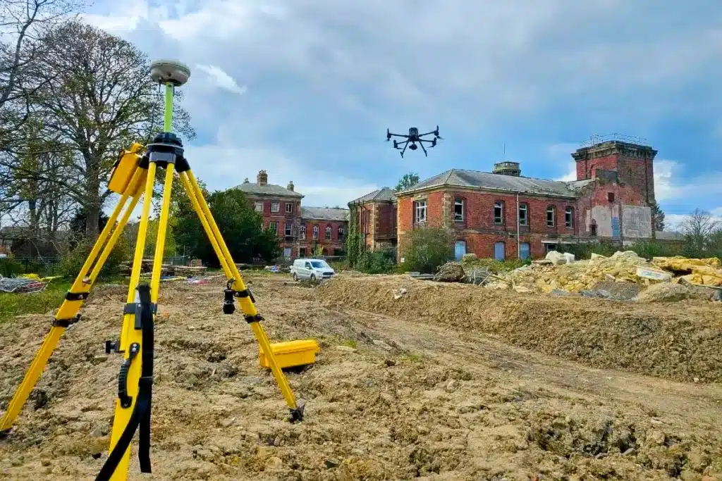
UAV survey before, during and after.
Pre-demolition site record. Progress monitoring during demolition and remediation. Post-remediation as-built confirmation. The UAV survey programme that tracks the full demolition and remediation lifecycle from a single firm.
Frequently Asked Questions
Frequently Asked Questions
What survey is required before a demolition programme begins?
Pre-demolition survey typically requires a combination of services depending on what is being demolished, what is being retained, and what the site will become after demolition. Measured building survey of the existing structures before demolition begins — providing the record that satisfies the planning authority’s requirement and protecting the contractor if any dispute arises about the pre-demolition condition of the building. PAS 128 utility mapping before any groundworks associated with the demolition programme — particularly important on brownfield sites with complex buried service histories. Topographic survey of the site before and after demolition for cut and fill and earthworks assessment. Monitoring of adjacent structures where demolition activity creates movement risk for neighbouring buildings.
Why is PAS 128 utility mapping particularly important on brownfield and demolition sites?
Brownfield sites and sites with existing structures carry the highest risk of undocumented buried services of any site type. Decades of service modifications, decommissioned service runs abandoned in place, undocumented connections between systems and services not represented in any statutory record are all common on brownfield land. PAS 128 Quality Level A — physical verification using vacuum excavation — is the appropriate standard before any demolition-associated groundworks on these sites. A service strike during demolition groundworks has the same consequences as one during construction. The standard that protects the programme applies equally to both.
Do you carry out pre-demolition measured building surveys?
Yes. A pre-demolition measured building survey produces a complete record of the existing structure before demolition — floor plans, elevations, sections and in some cases a laser scan point cloud — providing the documentary evidence that satisfies planning condition requirements, supports heritage recording where the building has historic significance, and protects the contractor in the event of any dispute about the pre-demolition condition. For listed buildings or buildings in conservation areas where demolition requires consent, the measured building survey is typically a condition of that consent.
What monitoring is required during demolition adjacent to existing structures?
Where demolition takes place in proximity to existing occupied buildings, structures or infrastructure, monitoring is required to detect and document any movement caused by the demolition programme. Settlement monitoring of adjacent structures, crack monitoring of existing fabric and vibration monitoring from demolition plant are all appropriate depending on the proximity, the sensitivity of adjacent structures and the demolition methodology. The trigger levels and monitoring programme should be specified by a structural engineer and implemented before demolition begins — not after movement is suspected.
Can you survey a contaminated or hazardous site?
We survey on sites where ground contamination is a known or suspected risk, adapted to the specific hazard profile. Where site investigation has identified contamination, we review the Phase 1 and Phase 2 environmental reports before mobilisation and produce method statements that reflect the specific hazard controls required. We do not carry out intrusive investigation of contaminated land — that is a specialist environmental engineering activity. We carry out topographic survey, UAV survey, laser scanning and other non-intrusive survey methodologies on sites where contamination is present, subject to appropriate hazard controls.
What UAV survey deliverables are useful for demolition and remediation programmes?
UAV survey is particularly useful for demolition and remediation in three specific applications. Pre-demolition site survey — rapid capture of the existing site conditions before demolition begins, including the roofs and upper facades of structures that ground-based survey cannot efficiently capture. Volumetric survey during remediation — tracking earthworks progress, material removal volumes and stockpile quantities throughout the remediation programme. Post-demolition as-built — confirming that demolition and remediation have achieved the required outcomes against the design specification.