


 Leeds
Leeds Doncaster
 Sheffield
 Bradford
 Hull
Hull Halifax
 Sunderland
 Newcastle
 Middlesborough
 Yorkshire Moors
 Teesside
 Cumbria
 Harrogate
 York
York Yorkshire Dales
 Northumberland
 Goole
Goole Carlisle
 Keswick
 Kendal
 Barrow-in-Furness
 Lancaster
 Blackpool
 Morecambe
 Southport
 Liverpool
 Wigan
Wigan Manchester
 Blackburn
 Burnley
 Forest of Bowland
 Oldham
 Chester
 Stockport
 Peak District
 Skipton
 Crewe
Crewe Rotherham
 Stoke
Stoke Driffield
Land and engineering surveyors based in Lancashire
Stockpile Surveys & Volumetric Analysis
Stockpile Surveys & Volumetric Analysis Lancashire and the North West
Accurate Stockpile Surveys Across Lancashire & the UK
Accurate Stockpile Surveys Across Lancashire & the UK
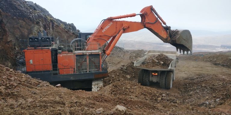
On active earthworks, quarry and aggregate sites, accurate volume data is not a nice-to-have — it is a commercial necessity. The volume of material extracted, moved, stockpiled or remaining on site determines how progress is measured against programme, how payment applications are verified, how material procurement is planned and whether commercial risks are identified before they become costly discrepancies that neither the contractor nor the client anticipated. Traditional manual estimation methods — tape measurements, wheel counts, GPS rod surveys at sparse intervals — introduce errors that compound over time and across large stockpile areas. The margin between an estimated volume and a surveyed volume on a significant stockpile can represent thousands of pounds of material. On a programme with multiple stockpile surveys over its duration, those margins add up.
Site Surveying Services delivers accurate stockpile surveys and volumetric analysis across Lancashire, the North West and nationally — using UAV photogrammetry, UAV LiDAR and laser scanning to capture full site coverage rapidly, safely and without stopping operations. Our directly employed UAV operators are surveyors first. The data they produce is georeferenced, accurate and delivered in the format your commercial team can act on directly — not raw point cloud data that needs processing by someone else before it is usable.
What is a stockpile survey?
A stockpile survey measures the volume of stored materials such as:
Survey Methods — Matching the Method to the Site
Survey Methods — Matching the Method to the Site
UAV photogrammetry — drone stockpile survey
Our primary method for open, large-area stockpile and earthworks surveys. The CHCNAV X500 UAV flies a pre-planned grid pattern over the survey area, capturing high-resolution overlapping photographs that are processed into a dense point cloud, Digital Surface Model and orthomosaic imagery of the full site. Ground control points established before the flight tie the data to OS National Grid.
UAV photogrammetry covers large quarry sites, construction compounds and aggregate yards rapidly — a site that would take days to survey on foot is captured in a single morning flight. Multiple stockpiles are captured simultaneously, producing a complete site volume inventory in one operation without stopping plant or disrupting site activity.
Best for: open quarry and aggregate sites, large construction compounds, multiple stockpile inventory, regular repeat surveys for progress tracking.
UAV LiDAR — drone LiDAR stockpile survey
For sites with complex terrain, steep stockpile faces, vegetation on or around stockpiles, or where the higher point density of LiDAR is required for accurate surface modelling. The CHCNAV X500 with LiDAR payload fires thousands of laser pulses per second, producing a denser, more accurate surface model than photogrammetry in difficult conditions.
LiDAR is particularly valuable for partially vegetated stockpile areas where photogrammetry captures the vegetation surface rather than the material beneath it, and for steep, irregular quarry faces where the photogrammetric surface model may be less reliable.
Best for: vegetated or partially covered stockpiles, steep quarry faces, complex terrain, high-accuracy requirements.
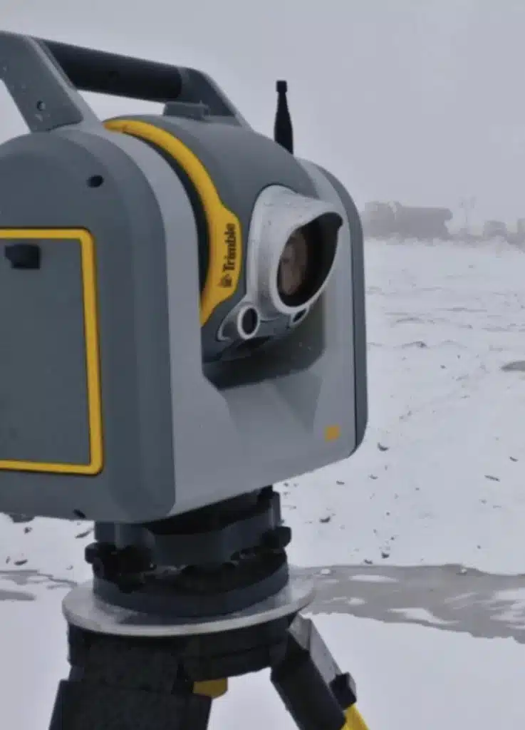
Laser scanning — terrestrial stockpile survey
For confined or internal storage areas — industrial warehouses, aggregate bays, salt storage domes, covered stockpile facilities — where UAV access is not possible and the highest-accuracy surface model is required. Our laser scanners capture millions of measured points per second from fixed positions, producing a highly accurate surface model of the stockpile interior.
Best for: indoor and covered storage facilities, confined aggregate bays, salt and de-icing material domes, industrial material storage.
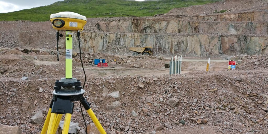
Traditional GPS survey
For smaller stockpiles or sites where UAV access is restricted, our surveyors capture stockpile surfaces using GNSS rovers and total stations on foot — recording a dense grid of surface points from which the volume is calculated. Appropriate for individual stockpiles in constrained environments.
Best for: single small stockpiles, restricted access sites, supplementary verification of UAV data.
What volumetric analysis actually involves
A volumetric analysis compares two three-dimensional surface models — typically an existing ground surface and either a proposed design surface or a subsequent survey surface — to calculate the volume of material between them. The accuracy of the result depends entirely on the accuracy of the surface models being compared.
For stockpile measurement
the existing ground surface beneath the stockpile is compared against the current surface of the stockpile to calculate its volume. Where the original ground surface is known from a pre-stockpile survey, that baseline is used. Where no pre-survey baseline exists, we establish the base surface from visible boundary features and ground level indicators at the stockpile perimeter.
For cut and fill analysis
the existing ground surface captured by survey is compared against the proposed design surface from the engineer's CAD model to calculate cut volumes (material to be removed) and fill volumes (material to be imported). The balance between cut and fill determines the net import or export requirement and the haulage cost implications for the programme.
For earthworks progress monitoring
repeated surveys at programme intervals are compared against the pre-construction baseline and the design surface to calculate how much material has been moved, how much remains and whether the programme is tracking against the planned cut and fill quantities.
For quarry extraction tracking
periodic surveys of the quarry face, bench levels and spoil areas document the volume of material extracted between survey dates, supporting royalty calculations, extraction licence compliance and site management reporting.
Why Are Stockpile Surveys Important?
Why Are Stockpile Surveys Important?
Traditional estimation methods can lead to significant inaccuracies. A professional stockpile survey provides dependable, defensible results. Accurate Volume Data Directly Affects:
Project Budgeting
Payment Verification
Material Procurement
Operational efficiency
Stockpile Survey methods we use
Drone Stockpile Surveys (UAV Photogrammetry)
Drone surveys allow rapid measurement of multiple stockpiles across large sites.
Ideal for:
- Quarry and aggregate sites
- Construction compounds
- Waste management facilities
- Bulk material storage yards
UAV LiDAR Surveys
For sites with complex terrain or vegetation, LiDAR provides enhanced surface modelling accuracy.
Ideal for:
- Uneven ground
- Large earthworks
- Vegetated stockpile areas coordination stages.
Laser Scanning
Laser scanning provides high-detail capture for confined, internal or complex material storage areas.
Ideal for:
- Industrial storage facilities
- Internal warehouses
- High-precision measurement requirements
Land Surveying Services
Stockpile and Volumetric Surveys for Your Sector
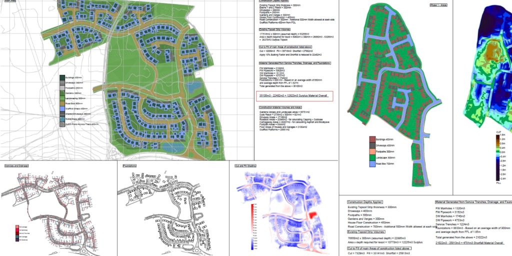
Deliverables & output formats
Deliverables & output formats
We provide clear, professional outputs ready for commercial and engineering use:
Volume Calculation Reports
Digital terrain models (DTM)
Digital surface models (DSM)
Contour maps
CAD drawings (DWG / DXF)
3D mesh models
GIS-ready datasets
Cut & Fill Analysis
Cut & Fill Analysis
In addition to stockpile measurement, we provide accurate cut and fill analysis, comparing existing ground levels to proposed design surfaces.
This helps project teams to:
Cut and fill analysis is essential for large civil engineering and infrastructure projects.
Estimate excavation quantities
Plan material redistribution
Optimise haulage logistics
Reduce waste and disposal costs
Our Services
How Stockpile & Volumetric Surveys Integrate With Our Other Services
How Stockpile & Volumetric Surveys Integrate With Our Other Services
Topographical Surveys
OS-controlled accurate, efficient and cost effective surveys for highways, civils and development. Cad and BIM-ready output.
PAS 128 utility mapping
Providing the location of underground services in 2D or 3D through qualified utility mapping surveys, using advanced GPR and Electromagnetic Location.
Measured building survey
Delivering accurate as-built information that supports design, refurbishment, planning and construction with the latest technology. Producing reliable drawings and digital models.
Laser Scanning
3D laser scanners capture millions of points per second, creating a point cloud which enables the finer details and the physical site to be viewed remotely.
Mobile mapping
For highway engineers, infrastructure managers, local authorities and contractors working on live road schemes, mobile mapping is now the standard for corridor surveys.
3D Machine control
With decades of supporting major earthworks contractors and large-scale infrastructure schemes, we provide reliable machine control across Lancashire and the wider UK.
Setting out engineers
With strong, long-standing relationships across the civil engineering and construction sector, we supply skilled professionals who keep your projects accurate, efficient and on programme.
bathymetric surveys & river surveys
Using modern technology, we capture detailed underwater and river channel information safely and efficiently – delivering reliable data you can trust.
Stockpile surveys & volumetric analysis
Whether a one-off stockpile measurement or regular monitoring, we deliver reliable, repeatable data tailored to your project using advanced technology.
Control Network Installation
Delivering robust and precise site control systems to support every stage of construction in developments, infrastructure schemes or major earthworks.
aerial & drone surveys
CAA-approved drone operations for aerial mapping, photogrammetry and volumetric analysis, providing a comprehensive view of terrain, structures and landscapes.
3D BIM Modelling
Whether you require an as-built Revit model, federated coordination model or detailed digital twin, our team delivers high quality, design-ready outputs.
survey equipment hire
We offer a vast range of surveying and engineering equipment for hire and will always try to beat a comparable quote. Discover the fleet.
monitoring
Providing reliable monitoring surveys across the UK, delivering precise data that supports risk management, compliance and informed decision making throughout a project lifecycle.
Virtual Tour 3D
An immersive experience which instantly transports your clients to your business, guiding them through your space and creating a seamless experience.
Impermeable area surveys
We deliver georeferenced impermeable area data that drainage engineers and planning consultants can work from directly.
CCTV & Drainage surveys
Acoustic & Noise Assessments
We deliver acoustic and noise assessments, supporting planning applications, discharge of conditions and Environmental Impact Assessments.
Topographical Surveys
PAS 128 utility mapping
Laser Scanning
Mobile mapping
Setting out engineers
bathymetric surveys & river surveys
Control Network Installation
aerial & drone surveys
survey equipment hire
monitoring
Impermeable area surveys
CCTV & Drainage surveys
3D Machine control
Acoustic & Noise Assessments
Stockpile surveys & volumetric analysis
3D BIM Modelling
3D BIM Modelling
Virtual Tour 3D
Why choose site surveying services
On site. On spec. On time.
No personnel near the active face.
The UAV captures volumetric data from the air. Stockpile face geometry, quarry face levels, earthworks progress — measured safely without anyone near the hazard zone.
Repeated surveys. Same datum. Direct comparison.
Every return survey tied to the same ground control network as the original. The data that allows direct comparison between survey dates. Volume change measured, not estimated.
CAD, PDF and spreadsheet. Your commercial team can use it immediately.
Volume breakdowns delivered in the format your site team require. Not raw data that needs processing. Usable data on the day of delivery.
Any programme stage. Any interval.
Monthly for interim valuations. Weekly for active quarry management. Pre-start and final for earthworks reconciliation. We match the survey frequency to your commercial programme.
Frequently Asked Questions
Frequently Asked Questions
What is a stockpile and volumetric survey?
A stockpile and volumetric survey uses UAV (drone) technology to capture an accurate, georeferenced point cloud of a site — measuring the volume of stockpiled material, the cut and fill on an earthworks programme, or the progress of excavation against a design. The point cloud is processed to produce a Digital Surface Model of the site at the time of survey, which is compared against a design surface or a previous survey to calculate volumes. The result is a measured volume figure — accurate, documented and defensible for commercial purposes.
How accurate is UAV volumetric survey?
With good ground control — GPS ground control points established by our survey team before the flight and tied to OS National Grid — UAV volumetric survey typically achieves ±50–100mm on surface levels, which translates to volume accuracy of approximately 1–3% on most stockpile and earthworks applications. This is significantly more accurate than visual estimation or tape-based measurement of stockpile dimensions, and is accurate enough for interim valuations, final account reconciliation and commercial management. Where higher accuracy is required for specific applications, we confirm the achievable accuracy at the time of scoping.
How often should I commission a volumetric survey on an active earthworks programme?
This depends on the pace of the programme and the commercial purpose of the data. For interim valuation purposes, monthly surveys tied to the programme’s valuation cycle are the most common arrangement. For quarry commercial management and stockpile reconciliation, fortnightly or even weekly surveys may be appropriate on active sites. For final account purposes, a pre-start survey establishing the existing ground model and a final survey at completion are the minimum required. We agree the survey frequency at the time of instruction and build it into a programme schedule.
Can you carry out volumetric surveys on live quarry sites without stopping operations?
Yes — and this is one of the primary advantages of UAV volumetric survey over conventional ground-based methods. The UAV survey is carried out from the air, without personnel in the quarry face or on the active extraction area. Operations continue normally throughout. The only requirement is a pre-flight safety check and a brief notification to site management before each flight. Our UAV pilots hold PDRA01 Operational Authorisation and GVC certification — all flights are CAA-compliant.
What is the difference between cut and fill calculations and stockpile volumes?
Cut and fill calculations compare the existing ground surface against a design surface — establishing how much material needs to be removed (cut) and how much needs to be placed (fill) across the earthworks area. This is the primary volumetric deliverable on construction earthworks programmes. Stockpile volume calculations measure the volume of material piled above a defined base plane — typically at a quarry, aggregate site or construction material storage area. Both are produced from the same UAV point cloud data but use different calculation methodologies. We confirm which deliverable your programme requires at the time of instruction.
What does the volumetric survey deliverable look like?
We deliver cut and fill volumes and stockpile volumes in CAD, PDF and spreadsheet format — structured for your commercial team to use directly. The CAD output shows the site with cut and fill zones colour-coded by depth. The PDF report presents the volume figures with the survey date, methodology and accuracy confirmation. The spreadsheet contains the volume data in a format compatible with commercial management and QS systems. Where repeat surveys have been commissioned, change detection maps showing volume change between survey dates are also produced.
Can you use previous survey data as a baseline for comparison?
Yes — provided the previous survey was georeferenced to OS National Grid and the point cloud or Digital Surface Model data is available. Where a pre-construction topographic survey or a previous UAV volumetric survey has been produced, we use it as the baseline for all subsequent comparison surveys. Where no previous survey exists, we commission a pre-start survey to establish the baseline before earthworks or extraction begins. We recommend always commissioning the baseline before operations start — retroactively establishing what the ground looked like before a programme began is significantly more difficult.
What areas do you cover?
Our head office is in Clitheroe, Lancashire, with offices in Matlock, Newcastle and Bristol. We deliver UAV volumetric surveys across the North West, North East, Midlands and South West as primary territories, and nationally. All work is carried out by our directly employed team.