


 Leeds
Leeds Doncaster
 Sheffield
 Bradford
 Hull
Hull Halifax
 Sunderland
 Newcastle
 Middlesborough
 Yorkshire Moors
 Teesside
 Cumbria
 Harrogate
 York
York Yorkshire Dales
 Northumberland
 Goole
Goole Carlisle
 Keswick
 Kendal
 Barrow-in-Furness
 Lancaster
 Blackpool
 Morecambe
 Southport
 Liverpool
 Wigan
Wigan Manchester
 Blackburn
 Burnley
 Forest of Bowland
 Oldham
 Chester
 Stockport
 Peak District
 Skipton
 Crewe
Crewe Rotherham
 Stoke
Stoke Driffield
Surveying Services North West
Site Surveying Services in Oldham, Greater Manchester
Oldham is a town with deep industrial roots and a clear ambition for its future — one of the original powerhouses of the cotton industry, now a borough committed to brownfield regeneration, housing delivery, and sustainable economic growth within the wider Greater Manchester conurbation. From its Pennine fringe villages to its town centre core, Oldham’s varied built environment generates consistent demand for professional surveying across residential, commercial, heritage, and infrastructure project types.
Site Surveying Services has delivered professional surveying work across Oldham for longstanding clients — from detailed topographic surveys in residential settings to specialist GPR borehole clearance on commercial sites. We are a trusted, reliable survey partner for clients across the borough, and we bring the same precision and responsiveness to every Oldham project, whether it’s a quick residential topo or a technically demanding utility detection commission.
Based in Clitheroe and well connected via the M60 and M62 corridors, we are within easy reach of Oldham for any survey requirement, with fast mobilisation and competitive pricing.
Our Surveying Services in Oldham
We offer a comprehensive range of professional surveying services to clients across Oldham and the wider Greater Manchester area:
Topographic Surveys Oldham
detailed land and site surveys for planning applications, drainage design, and residential and commercial development
GPR Utility Surveys & Borehole Clearance Oldham
ground-penetrating radar and electromagnetic detection to locate and map underground utilities, including pre-drill borehole clearance surveys
Measured Building Surveys Oldham
accurate floor plans, elevations, and sections for residential, commercial, and heritage buildings
3D Laser Scanning Oldham
high-density point cloud surveys for complex structures, heritage assets, and BIM production
Sectors We Serve in Oldham
Our Oldham project work covers a range of sector types reflecting the borough’s mix of residential, commercial, and industrial development:
Residential Development Oldham
topographic surveys for new-build housing, extensions, and residential conversions across Oldham's varied terrain
Commercial & Industrial Oldham
utility surveys and site surveys for commercial development, industrial sites, and brownfield regeneration
Infrastructure & Ground Investigation Oldham
GPR borehole clearance surveys to ensure safe drilling operations and minimise risk to underground services
Heritage & Conservation Oldham
measured surveys and laser scanning of Oldham's Victorian and Edwardian industrial heritage
Public Sector & Community Oldham
surveys for local authority and community facility projects across the borough
Surveying Case Studies & Project Highlights in Oldham
Case Studies & Project Highlights
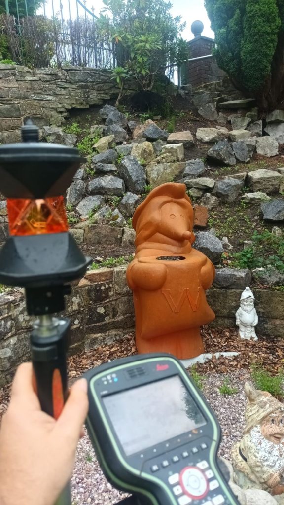
GPR Borehole Clearance, Sheepfoot Lane, Oldham
A technically precise and safety-critical commission, delivered for Ian Farmer Associates at Sheepfoot Lane in Oldham. The objective: to use ground-penetrating radar (GPR) and electromagnetic location technology to clear eight borehole locations before drilling commenced on site.
Pre-drill borehole clearance of this kind is an essential safety step in any ground investigation programme. Before drilling begins, it is critical to know exactly what lies beneath the surface at each proposed drill location — water mains, gas pipes, electrical cables, telecoms ducts, and other buried services all pose serious risks if struck during drilling. Our team used GPR to scan and map the subsurface conditions at each of the eight locations, detecting the presence and depth of buried services with high precision. This was complemented by electromagnetic location equipment to ensure accurate identification of utility lines and prevent any accidental strikes during the drilling process.
The thorough, methodical approach delivered detailed and reliable subsurface data to Ian Farmer Associates, significantly mitigating the risk of encountering underground services and ensuring that the subsequent drilling programme could proceed safely and efficiently. Delivered in a single day on site with half a day of office processing — exactly the fast, reliable turnaround that ground investigation programmes require.
Client details
Ian Farmer Associates
service provided
GPR Borehole Clearance / Utility Survey
Project timeline
1 day on site / approx. 0.5 days in the office
Topographic Survey, Oldham
Topographic Survey
Out on site in Oldham completing a detailed topographic survey for a longstanding client — a reminder that the bread and butter of our work is built on relationships and repeat business. A carefully executed topo, delivered efficiently, from a client who trusts us to get it right every time. Organised, thorough, clean — underground, overground, and on time.
Oldham's Development Landscape
Blackburn's Development Landscape
Oldham is one of Greater Manchester’s most active development boroughs, with a strong emphasis on brownfield regeneration, housing delivery, and the revitalisation of its town centre and former industrial sites. The borough’s housing targets are significant — with Places for Everyone setting a stepped requirement building to 772 homes per year through to 2039 — and the pressure on developers and landowners to bring forward viable brownfield sites is correspondingly high. A new Oldham-specific Local Plan is in preparation, intended to provide locally-specific policies and site allocations to complement the strategic Places for Everyone framework.
Why Choose Site Surveying Services in Oldham?
Why Choose Site Surveying Services in Oldham?
Longstanding local relationships
we have repeat clients across Oldham who trust us to deliver accurate, reliable survey data time after time
GPR and borehole clearance specialists
our Sheepfoot Lane project demonstrates our capability in safety-critical pre-drill utility clearance surveys, protecting ground investigation programmes from costly and dangerous strikes
Fast and efficient
delivering complex utility surveys in a single day with rapid office turnaround, keeping your programme on track
Full service range
from residential topos to GPR utility mapping, measured building surveys and laser scanning, all delivered in-house
Well connected to Oldham
accessible via M60 and M62, with fast mobilisation from our Clitheroe base
Competitive, transparent pricing
straightforward fees with fast quotations
Frequently Asked Questions
Frequently Asked Questions
Do you carry out GPR utility surveys and borehole clearance in Oldham?
What is a borehole clearance survey and why is it important?
A borehole clearance survey uses GPR and electromagnetic detection to identify underground utilities — pipes, cables, ducts — at proposed drill locations before any drilling begins. Striking an underground service during drilling can cause serious injury, significant damage, and costly programme delays. A clearance survey eliminates that risk, giving drillers confidence that each location is clear of buried services to the depth of the proposed borehole.
Do you carry out topographic surveys for residential projects in Oldham?
Yes — and residential topographic surveys are a regular and important part of our Oldham workload. Whether for a new-build planning application, a drainage design, or a site appraisal, we deliver detailed, accurate topo data efficiently and at competitive rates.
Can you survey brownfield and former industrial sites in Oldham?
Do you work with ground investigation companies in Oldham and Greater Manchester?
Yes. We work as survey subcontractors to ground investigation firms, geotechnical consultants, and structural engineers across Greater Manchester, providing the utility clearance, topographic, and setting out surveys that their programmes require. Ian Farmer Associates is one example of the kind of specialist consultancy we support.