

Precision data for sustainable decisions. Survey methodology that matches the environment.
Construction & Civil Engineering
Environmental and energy projects in the North West present survey challenges that standard construction methodology cannot always address. Wetland sites where ground-based access is restricted or harmful to the habitat. River corridors where the data needed lies beneath the water surface. Wind farm and solar development sites across challenging Pennine, Lakeland and moorland terrain. Flood risk assessments where every level and drainage feature matters to the modelling. Water infrastructure upgrade schemes operating under AMP8 investment where the survey data directly underpins programme-critical design decisions.
Site Surveying Services has been delivering survey across this sector since 1997 — using UAV LiDAR, unmanned surface vessels, remote sensing and GPS-controlled ground survey to capture data safely and accurately in environments where traditional methods are impractical, too slow or potentially damaging to what is being surveyed. We are Lancashire-based, nationally capable, and our equipment is specifically chosen for the environments this sector demands.
Surveying for Construction and Civil Engineering Projects
Surveying for Construction and Civil Engineering Projects
Yet even the smallest survey error or misalignment can cascade into costly rework, design clashes, or safety issues on-site. Contractors and developers need survey partners who understand the pressures of live sites: who can adapt quickly, deliver precisely, and keep projects on track no matter how complex the environment.
Why Accuracy Matters...
Every measurement, level, and coordinate influences the success of the final build. Accurate, coordinated survey data ensures that construction moves forward with confidence, allowing teams to:
Build safely
ensuring structures, excavations, and utilities align to design tolerances.
Reduce delays
avoiding rework and costly downtime caused by inaccurate or incomplete data.
Improve collaboration
providing unified datasets that integrate seamlessly with design, engineering, and BIM platforms.
Meet compliance standards
delivering verifiable records for QA, as-builts, and handover documentation.
Optimise efficiency
reducing repeat visits, downtime, and reliance on multiple contractors.
Innovation in Action
Innovation in Action
From laser scanning and drone data to BIM coordination, our technology enables faster decisions, fewer errors, and a complete record of every stage of construction. Our goal: to make accurate data the easiest part of your project.
Our Services
Topographical Surveys
OS-controlled accurate, efficient and cost effective surveys for highways, civils and development. Cad and BIM-ready output.
PAS 128 utility mapping
Providing the location of underground services in 2D or 3D through qualified utility mapping surveys, using advanced GPR and Electromagnetic Location.
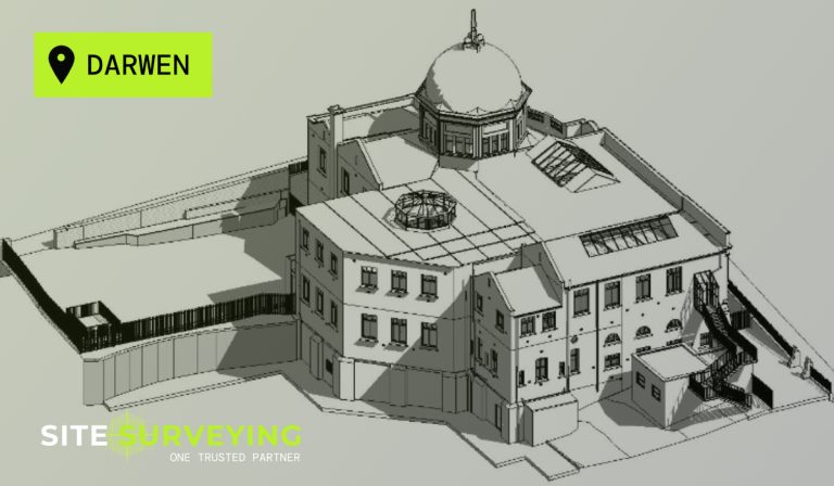
Measured building survey
Delivering accurate as-built information that supports design, refurbishment, planning and construction with the latest technology. Producing reliable drawings and digital models.
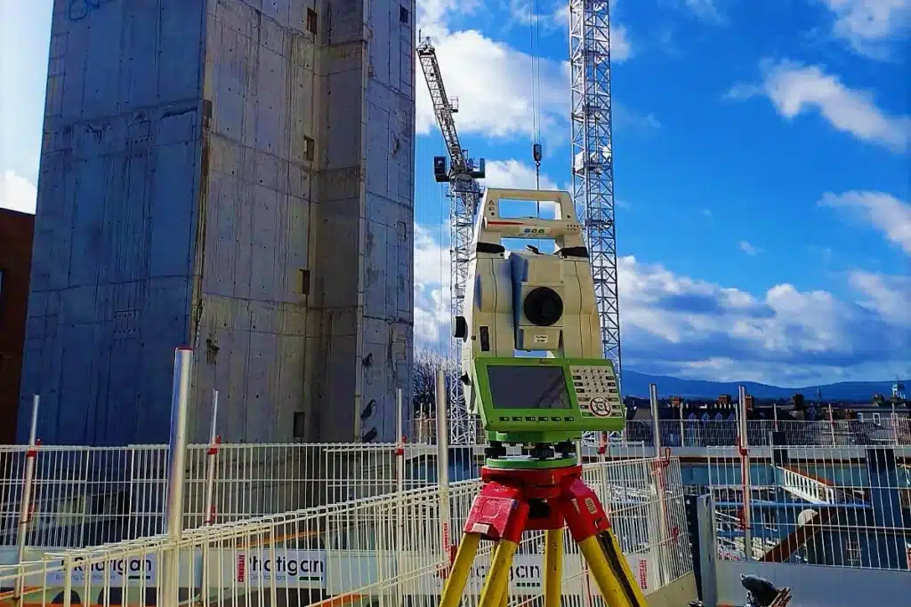
Laser Scanning
3D laser scanners capture millions of points per second, creating a point cloud which enables the finer details and the physical site to be viewed remotely.
Mobile mapping
For highway engineers, infrastructure managers, local authorities and contractors working on live road schemes, mobile mapping is now the standard for corridor surveys.
3D Machine control
With decades of supporting major earthworks contractors and large-scale infrastructure schemes, we provide reliable machine control across Lancashire and the wider UK.
Setting out engineers
With strong, long-standing relationships across the civil engineering and construction sector, we supply skilled professionals who keep your projects accurate, efficient and on programme.
bathymetric surveys & river surveys
Using modern technology, we capture detailed underwater and river channel information safely and efficiently – delivering reliable data you can trust.
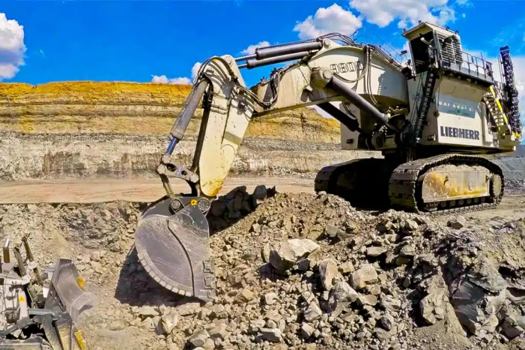
Stockpile surveys & volumetric analysis
Whether a one-off stockpile measurement or regular monitoring, we deliver reliable, repeatable data tailored to your project using advanced technology.
Control Network Installation
Delivering robust and precise site control systems to support every stage of construction in developments, infrastructure schemes or major earthworks.
aerial & drone surveys
CAA-approved drone operations for aerial mapping, photogrammetry and volumetric analysis, providing a comprehensive view of terrain, structures and landscapes.
3D BIM Modelling
Whether you require an as-built Revit model, federated coordination model or detailed digital twin, our team delivers high quality, design-ready outputs.
survey equipment hire
We offer a vast range of surveying and engineering equipment for hire and will always try to beat a comparable quote. Discover the fleet.
monitoring
Providing reliable monitoring surveys across the UK, delivering precise data that supports risk management, compliance and informed decision making throughout a project lifecycle.
Virtual Tour 3D
An immersive experience which instantly transports your clients to your business, guiding them through your space and creating a seamless experience.
Impermeable area surveys
We deliver georeferenced impermeable area data that drainage engineers and planning consultants can work from directly.
CCTV & Drainage surveys
Acoustic & Noise Assessments
We deliver acoustic and noise assessments, supporting planning applications, discharge of conditions and Environmental Impact Assessments.
Topographical Surveys
PAS 128 utility mapping
Laser Scanning
Mobile mapping
Setting out engineers
bathymetric surveys & river surveys
Control Network Installation
aerial & drone surveys
survey equipment hire
monitoring
Impermeable area surveys
CCTV & Drainage surveys
3D Machine control
Acoustic & Noise Assessments
Stockpile surveys & volumetric analysis
3D BIM Modelling
3D BIM Modelling
Virtual Tour 3D
Why choose site surveying services
On site. On spec. On time.
Directly employed setting-out engineers. On your site.
Over 600 setting-out and site engineering programmes in 2025. Directly employed, fully equipped, visiting or full-time — matched to your programme demand. Not agency. Not freelance. One firm accountable throughout.
CDM compliant. PAS 128. Constructionline Gold.
The complete pre-qualification profile for tier 1 construction supply chains. Available for documentation immediately. We work with Kier and BAM Nuttall — the supply chain track record is documented.
Survey from pre-start to as-built. One instruction.
Control network, PAS 128 utility mapping, topographic survey, setting-out, monitoring, as-built — all from one directly employed team. No coordination between separate survey firms. No inconsistent datums. One programme.
Frequently Asked Questions
Frequently Asked Questions
What survey is needed before a construction programme begins?
Every construction programme should begin with three pre-start survey activities. First, a topographic survey of the site — confirming existing ground levels, drainage, boundaries, services at surface and contextual features that the design depends on. Second, PAS 128 utility mapping to the quality level the programme requires — QLC at minimum, QLA at any location where excavation is planned and the consequence of a service strike is significant. Third, a control network — primary and secondary survey control installed, verified and documented before any setting-out or construction activity begins. These three surveys collectively protect the programme from the most common and most costly pre-construction surprises.
What is CDM and how does it affect survey?
The Construction Design and Management Regulations 2015 require the principal designer to gather pre-construction information — including information about utilities and underground services — before any construction begins. PAS 128 utility mapping is the standard methodology for satisfying this requirement on programmes involving excavation. Quality Level A physical verification is typically required where excavation is adjacent to high-pressure gas, high-voltage electricity, strategic water mains or other services where a strike would have serious consequences. Our PAS 128 accreditation, Constructionline Gold and CDM compliance are all current and available for pre-qualification documentation immediately.
How do setting-out engineers work alongside the construction team?
Our setting-out engineers are integrated into the construction programme — not occasional visitors. They work from the same design files as the structural engineer and drainage designer, check the data for consistency before they set out from it, flag conflicts between the design and the existing site conditions before concrete is poured, and verify as-built at programme milestones. On visiting arrangements they attend on agreed days each week — matched to the setting-out demand of the programme. On full-time placements they are present continuously. In both cases they are directly employed by Site Surveying Services and carry our professional indemnity insurance.
What is the right PAS 128 quality level for a construction programme?
Quality Level C — active detection using GPR and EML across the full works extent — is the appropriate baseline before any ground investigation or non-critical excavation. Quality Level A — physical verification at vacuum excavation test points — is required at locations where the design depends on accurate knowledge of service depth and position: structure foundations, drainage connections, service crossing points and any excavation where a strike would have significant programme or safety consequences. The right distribution of QLA test points across a construction site depends on the ground conditions, the service density and the specific works programme. We advise on this at the time of scoping.
Can you provide both topographic survey and setting-out engineers on the same programme?
Yes — and this is one of the most significant advantages of commissioning both from the same firm. Where we have produced the pre-construction topographic survey, the setting-out engineer working on the programme has access to the same spatial dataset, the same coordinate system and the same knowledge of the existing ground conditions. There is no translation between the survey firm and the setting-out team. The spatial knowledge of the site is consistent throughout the programme — from the first GPS observation to the last as-built check.
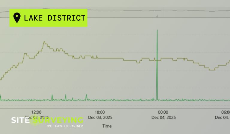
What monitoring is required adjacent to construction excavation?
The monitoring requirement depends on the excavation depth, the proximity to existing structures and infrastructure, the ground conditions and the structural sensitivity of what is adjacent. As a general principle, monitoring is appropriate for any excavation within approximately 1.5 to 2 times the excavation depth of existing structures. Settlement monitoring using precise levelling and structural movement monitoring using total station prism targets are the standard methods. Trigger levels are set by the geotechnical or structural engineer — we implement the monitoring programme to those trigger levels and report immediately when readings approach or reach threshold, not at the next scheduled visit.
What is a pre-construction condition survey and why is it needed?
A pre-construction condition survey is a photographic and written record of the existing condition of structures adjacent to proposed works — recording all existing cracks, defects, settlement, distortion and signs of distress before construction activity begins. It establishes a baseline that protects the contractor in the event of third-party claims for construction damage. Without a pre-construction condition survey, it is impossible to demonstrate that damage to a neighbouring property pre-existed rather than resulted from the construction programme. We produce pre-construction condition surveys as a standard part of all monitoring commissions.
Can you carry out as-built survey for planning condition discharge?
Yes. As-built topographic survey at practical completion — confirming earthworks levels, drainage inverts, structure positions and all built features against the design — is a standard part of our service to contractors and developers. Delivered in AutoCAD DWG in the format required by the planning authority and highways engineer for condition discharge. CCTV drainage survey of completed drainage for adoption is also available, coordinated alongside the topographic as-built.
Do you work with tier 1 contractors?
Yes. We currently deliver survey for Kier and BAM Nuttall and are experienced in the pre-qualification, method statement, CDM and programme requirements of tier 1 construction and infrastructure supply chains. Our Constructionline Gold accreditation satisfies the pre-qualification requirements of most tier 1 contractor frameworks immediately. We are also registered on Builders Profile and Avetta. If your supply chain has specific pre-qualification requirements, contact us and we will confirm our compliance status quickly.