

accurate survey data is the foundation of successful architectural design.
Surveying for Architects.
One Trusted Partner.
- ConstructionLine gold
- pas 128 qlb
- cdm 2015
- caa approved
- rics
- is0 9001 (in progress)
Need the full package?
Survey at Every Stage of the Architectural Design Process.
Survey at Every Stage of the Architectural Design Process.
Every architectural project — from a small residential extension to a large commercial refurbishment — depends on accurate survey data. The quality of that data at the start of the design process determines the quality of every decision that follows. Measurements that are wrong at RIBA Stage 1 become errors in the planning drawings, discrepancies in the structural engineer’s model, abortive work during construction, and disputes at handover.
Site Surveying Services works with architectural practices across Lancashire, the North West and nationally — from sole practitioners on residential projects to multi-disciplinary teams on major commercial, heritage and mixed-use schemes. We understand the RIBA design stages, we understand how survey data integrates into design workflows, and we deliver outputs that your practice can use immediately — not data that needs cleaning, converting or reprocessing before it is usable.
Surveying for architects Lancashire
Supporting Architectural Design with Reliable Data
Architectural surveys provide accurate, reliable site data that supports creative design, reduces planning risk, and informs confident decision-making from the outset. Site Surveying Services deliver architectural surveying services in the North West and across the UK, working closely with architects and planners from early feasibility and planning through to detailed design, BIM coordination, and construction. Our surveys are commissioned with a clear understanding of how information will be used in architectural workflows.
We understand the pressures of early-stage planning and the importance of dependable data when shaping design concepts. Our topographical surveys, measured building surveys, and 3D laser scanning are produced with clarity and consistency, ensuring seamless integration into CAD and BIM environments, planning submissions, and consultant coordination. The result is survey information you can rely on to define layouts, levels, constraints, and opportunities with confidence.
Survey Resources That Support Better Design Decisions
This resource hub is designed specifically for UK architects and planning consultants, bringing together practical guidance, real project examples, and downloadable resources to support efficient, well-coordinated project delivery. Whether you are preparing a planning application, developing a scheme, or coordinating multidisciplinary teams, these resources are built to add value at every stage. Every site and every building is different. Our role is to capture existing conditions accurately translating real-world environments into clear, usable survey data that reduces uncertainty and supports better design outcomes. With Site Surveying Services, architects and planners gain the clarity needed to move projects forward with confidence.
from feasibility studies to detailed technical design, our surveys help architects:
Understand Existing Site Conditions Clearly and Early
Identify Constraints Before They Become Costly Problems
Design With Confidence Using Dependable Base Data
Coordinate Effectively with Consultants and Contractors
How Site Surveying Services Works With Architects.
How Site Surveying Services Works With Architects.
Our approach is practical, collaborative, and design-led, ensuring survey data supports confident decision-making rather than introducing uncertainty.We understand the pressures architects work under:
Survey Data That Works for Architectural Design
A common issue for architects is receiving survey data that is either over-complicated or missing critical detail. We take time to understand how the survey information will be used, ensuring the scope aligns with design intent, planning requirements, and the project stage.This approach avoids wasted time, unnecessary cost, and late-stage surprises.
Clear Scope, Clear Outputs
A common issue for architects is receiving survey data that is either over-complicated or missing critical detail. We take time to understand how the survey information will be used, ensuring the scope aligns with design intent, planning requirements, and the project stage. This approach avoids wasted time, unnecessary cost, and late-stage surprises.
Responsive and Approachable
When questions arise or design requirements change, delayed responses can stall progress. From initial enquiry through to final delivery, our team remains accessible and responsive. We provide ongoing technical support, clarify information, and adapt survey scope where required - helping architects keep projects moving smoothly from feasibility through to planning and detailed design.
What Architects Need at Each RIBA Stage.
What Architects Need at Each RIBA Stage.
RIBA Stage 1
Preparation & Briefing:
At Stage 1, the architect needs to understand the site and the building well enough to prepare the project brief and advise the client on feasibility. Survey data at this stage informs the brief itself — it should not come after it.
What is typically needed:
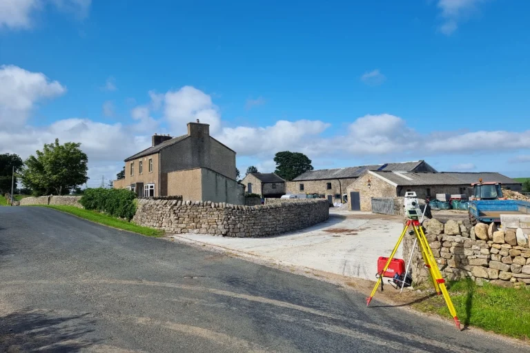
A measured building survey capturing the overall geometry, floor plan layout, ceiling and floor heights, external elevations and key internal features of the existing building. A topographic survey of the site capturing ground levels, boundaries, existing structures, drainage and context. In most cases, a desktop utility search to flag the presence of underground services before the brief is finalised.
What we deliver:
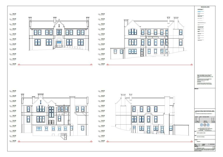
Measured building survey to 1:50 or 1:100 scale as appropriate, floor plans, elevations and sections in AutoCAD DWG format. Topographic survey to OS National Grid tied to a local level datum. Deliverables in the format your practice works in from day one.
RIBA Stage 2
Concept Design:
At Stage 2, the survey data underpins the concept design. Ground levels inform the massing and relationship of the building to its context. Existing building dimensions inform the refurbishment or extension scheme. The survey at this stage needs to be accurate enough for concept design — and it needs to capture everything the concept design depends on.
What is typically needed:
For new build or extension — a full topographic survey with accurate levels, boundaries and contextual features. For refurbishment — a full measured building survey including floor plans, elevations, sections, roof geometry, window and door openings, ceiling heights and structural features. Where BIM is a project requirement, the survey scope should be agreed at this stage and the data produced to the appropriate LOD.
What we deliver:
Full measured building surveys using 3D laser scanning — capturing all internal and external detail including confined spaces, low-light environments and complex geometry that tape surveys cannot reliably record. Point cloud data registered and georeferenced, processed in-house to produce floor plans, elevations and sections to your specification.
RIBA Stage 3
Spatial Coordination:
At Stage 3, the design is being spatially coordinated across disciplines. Survey data that is inaccurate or incomplete at this stage introduces clashes between the architectural model and the structural and services designs. The cost of resolving those clashes increases significantly as the project progresses.
What is typically needed:
If the survey was not produced to BIM standard at Stage 2, this is the last practical opportunity to commission a BIM-ready survey before coordination work is underway. The survey model needs to be at the right LOD, in the right coordinate system and in the right format for the structural engineer and MEP consultant to work from.
What we deliver:
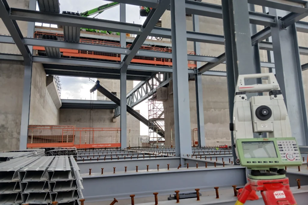
BIM model creation to the LOD specified in your Employer's Information Requirements — produced in-house from laser scan data, in Revit or the format your project team requires. All survey data georeferenced and coordinated to a common datum. We produce 3D models, point clouds and coordinated datasets that are accurate, verified and ready to use without reprocessing.
RIBA Stage 4
Technical Design:
At Stage 4, the technical design is being developed and the construction information is being produced. Survey data at this stage supports detail design — accurate dimensions for structural and building envelope design, confirmed levels for drainage and services coordination, verified positions for building elements.
What is typically needed:
Verification of key dimensions and levels where the Stage 2 or 3 survey data needs to be confirmed at greater accuracy for technical design. As-existing records of any changes to the building that have occurred since the original survey. Utility mapping if not already commissioned — any scheme involving excavation near the building requires PAS 128 utility mapping before construction begins.
What we deliver:
Check surveys and supplementary data capture to verify specific dimensions or features. PAS 128 utility mapping to Quality Level A, B, C or D — using GPR and EML to physically verify the location of underground services before construction starts.
RIBA Stage 5
Manufacturing and Construction:
At Stage 5, the contractor is on site. The survey team shifts from supporting design to supporting construction — setting out, as-built verification and quality checks.
What is typically needed:
Setting-out support where the architect is involved in construction oversight. As-built surveys at key construction stages to verify that work has been carried out in accordance with the design. Where the project is on a tight site or involves complex geometry, periodic laser scans can verify construction accuracy before the next stage proceeds.
What we deliver:
Directly employed setting-out engineers and engineering surveyors for projects of any scale. As-built survey at programme stages using total station and laser scanning. All delivered by the same team that has been involved with the project from survey — continuity of knowledge, no handoff gaps.
RIBA Stage 6
Handover:
At Stage 6, the building is complete and the client needs a complete record of what has been built. The as-built survey forms part of the building's O&M documentation and provides the baseline data for any future works.
What is typically needed:
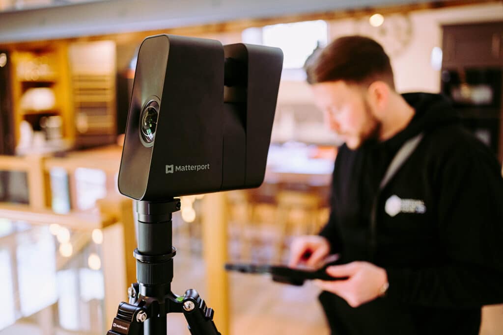
Final as-built measured building survey capturing the building as constructed — confirming dimensions, levels and positions against the design. Point cloud data for the project record. Virtual Tour 3D for client handover, marketing and operational use.
What we deliver:
Full as-built measured building survey, georeferenced point cloud, floor plans and elevations to the specification agreed with the client. Virtual Tour 3D using Matterport Pro 3 — producing an immersive, interactive digital twin of the completed building for the client, occupants and future design teams.
Surveying Services
Most Used by Architects.
Surveying Services Most Used by Architects.
Measured building surveys
Floor plans, elevations, sections, roof layouts and 3D models to your specification. All produced in-house using 3D laser scanning. Delivered in AutoCAD DWG, Revit or your preferred format.
Topographic survey
OS-controlled survey of site levels, boundaries, drainage, vegetation and contextual features. CAD-ready output from day one.
Laser scanning and point cloud
High-density 3D scan data for complex geometry, heritage buildings, confined spaces and BIM workflows. Processed in-house from capture to deliverable.
BIM model creation
Survey data delivered to your EIR, at the LOD your project requires, in Revit or AutoCAD. Built around your BIM specification from the first conversation.
PAS 128 utility mapping
Underground service location before any excavation. Quality Level A means physical verification, not desktop records.
Virtual Tour 3D
Matterport Pro 3 digital twins for client presentations, planning support, heritage recording and handover documentation.
survey for planning application architect North West
Case Studies: Survey Data in practice
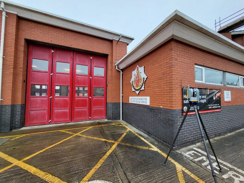
Eccles Fire Station Refurbishment
Measured building survey and laser scanning at a live fire station — coordinated around operational shifts, emergency drills and vehicle movements. Complete internal and external building data captured without disrupting a single callout. The survey data gave the architectural team a complete, accurate record of the existing building before refurbishment design began.
Case Studies: Survey Data in practice
HMP Manchester — Security-Critical Surveying
Measured building survey in a secure custodial environment. Strict access protocols, coordination with site security, phased access to different areas of the estate. The architectural team received a complete, accurate measured building survey to support refurbishment planning — delivered by a team experienced in security-critical environments.

Why choose site surveying services
On site. On spec. On time.
Working with Site Surveying Services means partnering with an experienced provider of architectural surveying services that understands both the practical and creative demands of architectural design. We work collaboratively with architects, planning consultants, national housebuilders, local developers, and landowners, delivering architectural site surveys that align with project programmes, design workflows, and planning requirements.
Our experience in surveying for architects allows us to anticipate the information required at each stage of a project. Whether supporting a planning application, coordinating detailed design, or providing BIM-ready survey data, we deliver clear, accurate outputs that integrate seamlessly into architectural and multidisciplinary teams.
We offer a comprehensive range of architectural and property surveying services, tailored to different building types, site constraints, and development scales. Site Surveying Services is committed to quality, communication, and consistency. By combining technical surveying expertise with a strong understanding of CAD and BIM workflows, we help ensure projects progress efficiently from concept, through planning, and into construction.
For architects seeking reliable survey support, we provide accurate, usable site information that helps turn design intent into deliverable, buildable projects.
If you would like to discuss a project, request a quotation, or need advice on the most appropriate survey approach, our team is always happy to help.
fast turnaround
Get a quick quote and a survey team prepared for instruction. When the programme window opens, we're ready.
Industry Accredited
Built on recognised industry standards. Constructionline Gold accredited, CAA Approved, CDM 2015 compliant, and surveys delivered to PAS 128
Nationwide
Coverage across the UK with local knowledge you can rely on. Headquartered in Clitheroe, we know the sites, the contractors and the programmes — backed by the capability to deliver anywhere.
Programme-Critical
Data that works in your environment from day one. BIM to your EIR. CAD to your spec. No reprocessing. No delays to the design team.
Frequently Asked Questions
Frequently Asked Questions
What survey do I need before I start designing?
For a new build project on a vacant site, you need a topographic survey capturing ground levels, boundaries, drainage, vegetation and contextual features. For a refurbishment or extension project involving an existing building, you need a measured building survey capturing floor plans, elevations, sections and ceiling heights — and a topographic survey of the external site. If the project involves any excavation, you should also commission a desktop utility search at minimum, or PAS 128 utility mapping if the project is going to planning or construction. Commissioning survey at the start of Stage 1 rather than partway through Stage 2 is consistently more cost-effective — it prevents the brief being based on assumptions that the survey later contradicts.
What format will the survey be delivered in?
We deliver all survey data in the format your practice works in. AutoCAD DWG is the most common requirement — we will confirm the version at the time of instruction. For BIM projects, we deliver in Revit or IFC format to the LOD specified in your EIR. For planning and heritage submissions, we produce PDF plans alongside the CAD data. Tell us what you need at the time of enquiry and we will build it into the deliverable specification before survey.
What LOD should I specify for my BIM survey?
This depends on the project stage and how the model will be used. LOD 200 is sufficient for concept design and planning — it captures overall geometry and massing but not fine detail. LOD 300 supports technical design coordination — accurate dimensions, structural positions, opening sizes. LOD 400 captures full construction detail and is required for complex refurbishment, heritage recording and projects where the construction team will work directly from the model. LOD 500 is the as-built record. If you are not sure what LOD is appropriate for your project stage, we will advise — it is one of the most common questions we are asked, and the answer depends on what the model needs to support downstream.
Can you deliver survey data in Revit?
Yes. We produce Revit models in-house from laser scan data — structured to your EIR, at the LOD specified, in the Revit version your practice uses. All work is produced by our directly employed team, not outsourced. The survey data and the model are produced by the same team, which means the output you receive has been checked against the scan data before it is delivered.
What is a point cloud and how do I use it in my design workflow?
A point cloud is the raw output of a laser scan — millions of measured data points representing the geometry of a space in three dimensions. In a design workflow, point clouds can be imported into Revit, AutoCAD, Rhino, SketchUp and most other major design platforms, allowing the designer to view and measure the existing building in 3D directly within their working environment. Point cloud data is particularly useful for complex geometry, heritage buildings and refurbishment projects where the existing fabric is irregular and difficult to capture accurately by tape. We deliver point cloud data in RCP, RCS, E57 or LAS format — confirm your preference at the time of instruction.
Do I need a measured building survey or a laser scan — what is the difference?
A measured building survey is a deliverable — the floor plans, elevations and sections you need for design. A laser scan is the methodology used to produce it. We use 3D laser scanning to capture the data for all our measured building surveys — it is more accurate, faster and captures far more detail than traditional tape and offset methods, particularly in complex or confined spaces. When you commission a measured building survey from us, you are commissioning both the scan and the processed deliverables. We can also provide the raw point cloud data as an additional deliverable if your workflow requires it.
How accurate is a measured building survey?
Our measured building surveys are typically accurate to ±5–10mm for internal dimensions. External elevations are captured to a similar tolerance. Where higher accuracy is required — for structural design, for example, or for heritage recording — we can increase the specification and confirm the achievable accuracy at the time of scoping. All surveys are produced with a methodology statement confirming the equipment used, the accuracy achieved and the date of survey.
What information should I provide when commissioning a survey?
The more information you give us at the outset, the better the survey will be scoped and the less risk of additional visits to capture missed features. Useful information includes: the address and access arrangements, any existing drawings (even if inaccurate — they help us understand the building), the intended use of the survey data and the design stage it needs to support, the preferred deliverable format, any specific features that need particular attention, and the programme timescale. If you are not sure what to specify, tell us what the survey needs to support and we will advise on the scope — it is one of the things we do every day.
Will the survey data tie to OS National Grid?
Yes. All topographic surveys are tied to OS National Grid as standard. Measured building surveys are set up on a local grid derived from the topographic survey control — which means the building model can be accurately positioned within its site context. If you need the survey tied to a specific coordinate system for BIM or structural coordination purposes, confirm this at the time of instruction.
Can you come back and do additional survey if the design evolves?
Yes. We maintain all control networks and survey datum information from each project, which means a return visit can be tied accurately to the original survey without re-establishing control. This is particularly useful on phased projects, projects where the design brief evolves during Stage 2 or 3, and heritage projects where periodic condition records are required over time. We also offer standing arrangements for architectural practices who commission survey regularly — a single point of contact and agreed rates for each project type.
Do you offer CPD sessions for architectural practices?
Yes. We offer free CPD sessions for architectural practices covering the practical integration of survey data into design workflows — including BIM delivery methodology, point cloud use in Revit, the difference between survey types and when to use each, and common survey issues that cause design problems. Our first CPD session was delivered to the team at Cassidy Ashton in Preston. If your practice would benefit from a session, contact us to arrange a date.
Are you RICS regulated?
Yes. Site Surveying Services is RICS regulated — Royal Institution of Chartered Surveyors. This provides the professional indemnity and quality assurance framework that architectural practices and their clients expect when survey data is underpinning design and planning decisions. Our RICS membership is current and can be confirmed on request.
What areas do you cover?
Our head office is in Clitheroe, Lancashire, with additional offices in Matlock, Newcastle and Bristol. We cover the North West, North East, Midlands and South West as primary territories and deliver nationally. All survey work is carried out by our directly employed team — not subcontractors. There is no project too far for us to take on if the programme requires it.