


 Leeds
Leeds Doncaster
 Sheffield
 Bradford
 Hull
Hull Halifax
 Sunderland
 Newcastle
 Middlesborough
 Yorkshire Moors
 Teesside
 Cumbria
 Harrogate
 York
York Yorkshire Dales
 Northumberland
 Goole
Goole Carlisle
 Keswick
 Kendal
 Barrow-in-Furness
 Lancaster
 Blackpool
 Morecambe
 Southport
 Liverpool
 Wigan
Wigan Manchester
 Blackburn
 Burnley
 Forest of Bowland
 Oldham
 Chester
 Stockport
 Peak District
 Skipton
 Crewe
Crewe Rotherham
 Stoke
Stoke Driffield
Surveying Services North West
Site Surveying Services in Liverpool, Merseyside
Liverpool is one of the UK’s most iconic cities — a global port, a UNESCO World Heritage waterfront, a powerhouse of culture and heritage, and a city undergoing sustained and ambitious regeneration across its docklands, commercial core, and residential neighbourhoods. From the Jaguar Land Rover facility at Speke to the historic structures of the waterfront, and from Peel Ports’ vast dock estate to the magnificent Metropolitan Cathedral, Liverpool presents a surveying environment of extraordinary scale, variety, and prestige.
Site Surveying Services has delivered professional surveying work across Liverpool and Merseyside, working with engineering consultants, port operators, and clients with large-scale industrial and heritage survey requirements. We bring advanced scanning technology, PAS128-compliant utility mapping capability, and the multi-discipline survey expertise that Liverpool’s complex, active project environments demand.
Whether your project is on the docks, in the city centre, at a major manufacturing facility, or within one of Liverpool’s exceptional heritage buildings, our team delivers accurate, reliable data — efficiently and within budget.
Our Surveying Services in Liverpool

3D Laser Scanning Liverpool
high-density point cloud surveys using Trimble X7 and other advanced scanners for industrial facilities, heritage buildings, complex structures, and large-scale external surveys
Topographic Surveys Liverpool
detailed land and site surveys for planning, development, and infrastructure across Liverpool and Merseyside
PAS128 Utility Mapping Liverpool
underground utility detection, verification, and location to the UK standard, using GPR and electromagnetic detection equipment
Measured Building Surveys Liverpool
precise floor plans, elevations, and sections for heritage, commercial, and industrial buildings
Sectors We Serve in Liverpool
Our Liverpool project portfolio reflects the diverse and dynamic character of one of the UK’s most significant cities:
Automotive & Manufacturing Liverpool
laser scanning for major vehicle manufacturers and industrial facilities at Speke and across Merseyside
Port & Docklands Liverpool
multi-discipline surveys across Peel Ports Liverpool and the wider dock estate, including point cloud surveys, topography, and utility mapping
Heritage & Conservation Liverpool
surveys of Liverpool's extraordinary stock of listed buildings, world heritage structures, and iconic landmarks
Commercial & Regeneration Liverpool
surveys supporting Liverpool's major waterfront, city centre, and docklands regeneration programmes
Infrastructure & Utilities Liverpool
PAS128 utility mapping and topographic surveys for infrastructure and public realm projects across the city
Education & Healthcare Liverpool
surveys for Liverpool's university campuses and major healthcare facilities
Surveying Case Studies & Project Highlights in Liverpool
Case Studies & Project Highlights
Jaguar Land Rover, Speke — 3D Laser Scanning
The survey had two primary requirements: precise external scans of the building facades to provide detailed measurements and structural data for bridge design and placement; and detailed scanning of the pitched roofs to accurately measure gradients and heights, and identify any obstacles — vents, protrusions, and other features — that could impact the new construction.
The Trimble X7 was the tool of choice for this commission — selected for its high precision, rapid data acquisition, and ability to produce detailed 3D models of complex exterior building forms. Particular care was taken around the pitched roof scanning, where safety protocols and strategic scanner positioning ensured comprehensive coverage while maintaining safe working conditions throughout.
The resulting 3D models and survey data gave Jaguar Land Rover and their design team the precise spatial information needed to optimise the bridge design and ensure the efficient execution of the new vehicle test facility — all from a single day on site.
Client details
Gravitate Consultants
service provided
3D Laser Scanning
Project timeline
1 day on site / approx. 0.5 days in the office
Peel Ports Liverpool — Point Cloud, Topography & PAS128 Utility Mapping
3D Laser Scanning, Topographic Survey & Utility Mapping
The result was a single, coordinated commission covering all three disciplines — point cloud survey, topography, and PAS128 utility mapping — delivered in-house, on tight time constraints, and within budget. As the client put it directly: “It’s so much easier for us using one contractor for the whole works, it gives us that consistency across the project from start to finish.”
This is exactly the kind of multi-discipline, single-contractor delivery that saves port and industrial operators time, reduces coordination risk, and ensures every dataset is tied to the same control framework. Your one-stop survey shop — and a sentiment we hear regularly from clients who’ve experienced the alternative.
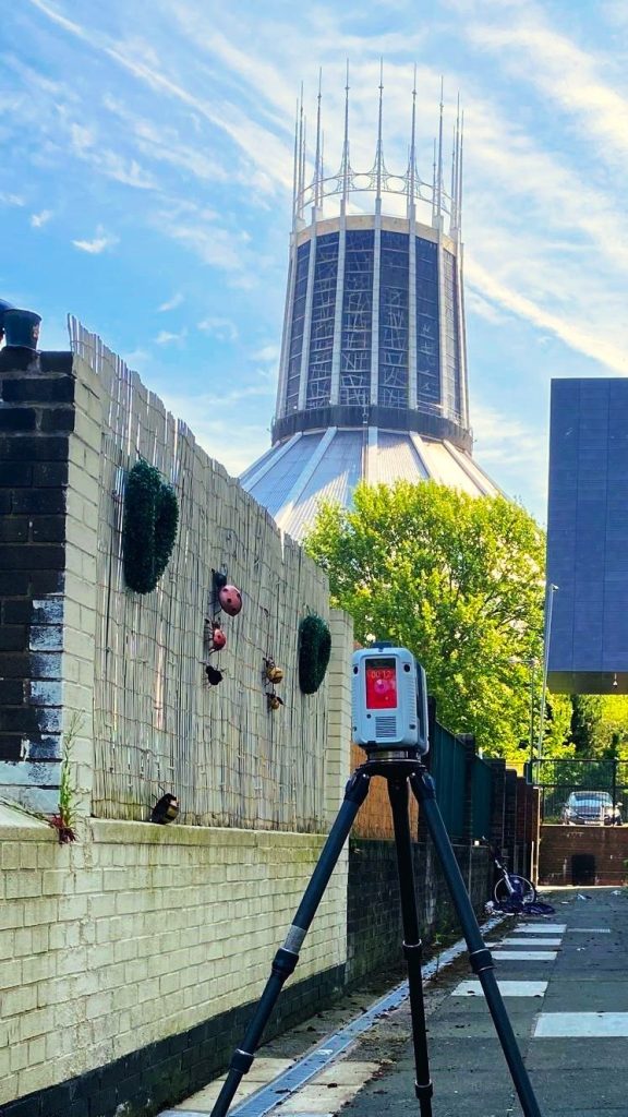
Liverpool Metropolitan Cathedral — Survey
No matter how many times you encounter certain buildings, some architectural achievements genuinely stop you in your tracks. Liverpool Metropolitan Cathedral is unquestionably one of them — a modernist masterpiece that has served as the backdrop to some of our most memorable days on site in the city. A privilege to work alongside, and a reminder that surveying in Liverpool means working in the presence of some of the finest buildings in England.
Liverpool Docks — Topographic, Laser Scanning & PAS128 Utility Mapping
Topographic Survey, Laser Scanning & PAS128 Utility Mapping
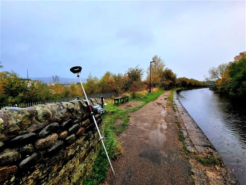
Following earlier topographic and laser scanning work at Liverpool Docks, our team returned to site to undertake a full PAS128 utility mapping survey — the UK standard for underground utility detection, verification, and location. Working on a live dock environment demands careful coordination, robust method statements, and equipment that performs reliably in exposed, industrial conditions. Our team delivered across all three phases, providing the client with a comprehensive spatial and utility dataset to support ongoing development and maintenance planning across the dock estate.
What is PAS128? PAS128 is the UK’s national standard for underground utility surveys. It defines four levels of survey quality — from desktop study (Level D) through to physically exposing utilities (Level A) — and ensures that utility detection is carried out methodically, documented accurately, and delivered to a consistent, reliable standard. For any project involving excavation, construction, or infrastructure works, a PAS128 survey is essential for safety, cost control, and regulatory compliance.
Liverpool's Development Landscape
Liverpool's Development Landscape
Liverpool is one of the UK’s most ambitious regeneration cities. The Liverpool Waters project continues to reshape the northern docks into a major mixed-use waterfront district, while the Baltic Triangle, Ten Streets, and city centre core attract sustained commercial and residential investment. Major healthcare and education estates including the Royal Liverpool University Hospital and the city’s universities underpin long-term demand for professional survey services across the city. Liverpool’s current planning framework is the Liverpool Local Plan (2013–2033), the adopted development plan for the city. A new draft Liverpool Local Plan 2025–2041 is currently in active Regulation 18 consultation, with the new plan expected to guide the city’s growth and regeneration through to 2041.
Why Choose Site Surveying Services in Liverpool?
Why Choose Site Surveying Services in Liverpool?
Industrial and port specialists
delivering laser scanning, topography, and utility mapping across some of Liverpool's most complex and demanding operational environments
PAS128-compliant utility mapping
full in-house capability for underground utility detection and mapping to UK standard, essential for any excavation or infrastructure project in Liverpool
Multi-discipline, single contractor
as Peel Ports confirmed, using one contractor for point cloud, topography, and utility mapping saves time, reduces coordination risk, and delivers consistency
Trimble X7 scanning technology
delivering high-precision, rapid-acquisition point cloud data for demanding industrial and heritage applications
Heritage experience
from the Metropolitan Cathedral to Liverpool's world heritage waterfront, we understand the specific demands of surveying in Liverpool's iconic built environment
Competitive and reliable
delivered in-house, on time, within budget. Every time.
Frequently Asked Questions
Frequently Asked Questions
Do you carry out PAS128 utility surveys in Liverpool?
Yes — and we have done so at Liverpool Docks and other major Liverpool sites. PAS128 is the UK standard for underground utility detection, verification, and location. We carry out surveys with PAS128 B quality level and can combine utility mapping with topographic and laser scanning work in a single coordinated commission, as we did at Peel Ports Liverpool.
Can you carry out laser scanning at large industrial facilities in Liverpool?
Yes. Our Jaguar Land Rover commission at Speke is a strong example — a demanding external scan of a large industrial complex with specific requirements around roof gradient measurement and obstacle identification, delivered in a single day using the Trimble X7. We are experienced in working safely and efficiently on major industrial and manufacturing sites.
Do you survey port and dockside environments in Liverpool?
Yes. Peel Ports Liverpool is one of our most significant port commissions, combining point cloud survey, topographic survey, and PAS128 utility mapping in a single integrated package. Port and dock environments present specific access, safety, and operational constraints; our team has the experience and method statements to work within them effectively.
Can you combine multiple survey types into a single commission in Liverpool?
Yes — and we strongly recommend it where possible. Our Liverpool projects demonstrate exactly this: laser scanning, topography, and utility mapping delivered in a coordinated package by a single team, providing consistent, accurate data across all disciplines without the coordination overhead of multiple contractors.
Do you survey heritage and listed buildings in Liverpool?
Yes. Liverpool’s built heritage — from its world heritage waterfront to the Metropolitan Cathedral — is extraordinary, and we are experienced in surveying complex, sensitive historic structures using scanning, measured survey, and UAV technology.
How quickly can you mobilise for a project in Liverpool?
Liverpool is approximately 50–60 minutes from our Clitheroe base via the M6 and M62. For most project types we can mobilise within 24–48 hours of instruction. For urgent industrial or port-related requirements, contact us directly to discuss timescales.