

Survey on live industrial sites. The methodology, the compliance record and the working practices that demanding environments require.
Industrial & Logistics Surveying
Surveying for Rural & Agricultural Projects
Surveying for Rural & Agricultural Projects
They’re large, active, and often contain restricted areas, heavy machinery, and safety-critical infrastructure. Every project must balance precision with practicality; keeping downtime minimal, maintaining safe operations, and ensuring that upgrades and expansions are built on verified data. Whether you’re reconfiguring production lines, expanding storage capacity, or planning a retrofit to improve energy efficiency, even the smallest measurement error can cause costly downtime or compliance issues.
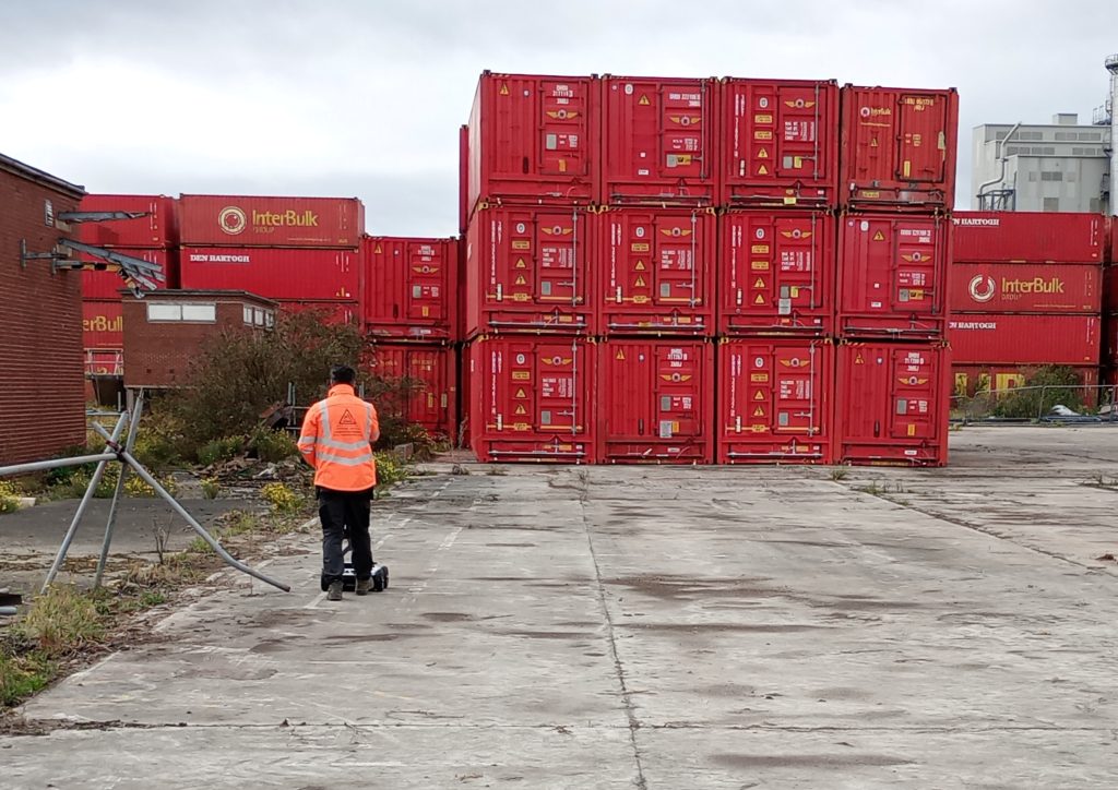
Industrial and logistics facilities are some of the most technically demanding survey environments we work in — not because the data requirements are unusual, but because the environment in which the data must be captured is. A live manufacturing plant does not stop because a survey team has arrived. A food production facility cannot be entered without hygiene compliance. A chemical plant has permit-to-work requirements that govern every activity within the boundary fence. A logistics hub with round-the-clock operations has no convenient access window.
The survey firms that cannot operate in these environments cite the constraints as reasons they cannot help. The survey firms that can — who have planned around shift patterns, obtained permits to work, satisfied hygiene protocols, adapted laser scanning methodology for explosive atmosphere zones and produced method statements that the facilities manager actually reads — are genuinely useful on live industrial programmes.
Site Surveying Services delivers survey on live operational industrial and logistics facilities across Lancashire, the North West and nationally. Our team understands the working practices, compliance requirements and access constraints that these environments impose — and we design our survey methodology around them from the outset.
Why Accuracy Matters...
Accurate survey data ensures every modification, extension, or installation is built on certainty. It allows clients to:
Plan safely and efficiently
avoiding clashes between new and existing structures or M&E systems.
Maintain compliance
with health, safety, and building regulations.
Visualise complex environments
with 3D data that supports design coordination and asset management.
Minimise downtime
during construction or refurbishment by enabling precise planning and sequencing.
Futureproof operations
through digital records and BIM models for long-term facility management.
Innovation in Action
Innovation in Action
These digital twins allow teams to visualise every asset, duct, and beam with millimetre accuracy, reducing the need for site visits and ensuring that refurbishment or expansion works proceed without disruption.

The Industrial and Logistics Sector in the North West
The Industrial and Logistics Sector in the North West
The North West has one of the largest concentrations of industrial and logistics property in the UK — manufacturing, food and drink production, chemicals, aerospace, defence manufacturing, distribution and logistics. Several distinct investment drivers are generating survey demand across the sector:
Manufacturing expansion and retrofit
manufacturing facilities across Lancashire, Greater Manchester, Cheshire and Cumbria are expanding, upgrading and adapting their plant and processes. Before any refurbishment, extension or process change can be designed, an accurate as-existing record of the building, its services and its structural fabric is needed. Laser scanning and SLAM scanning produce this record from a live operational facility without requiring production to stop.
Logistics and distribution growth
the North West’s position as a distribution hub — served by the M6, M61, M62 and M65, and with major rail freight connections — has driven sustained growth in large-format logistics and warehouse development. New build, fit-out and expansion of existing facilities all require topographic survey, measured building survey and PAS 128 utility mapping.
Defence and aerospace manufacturing
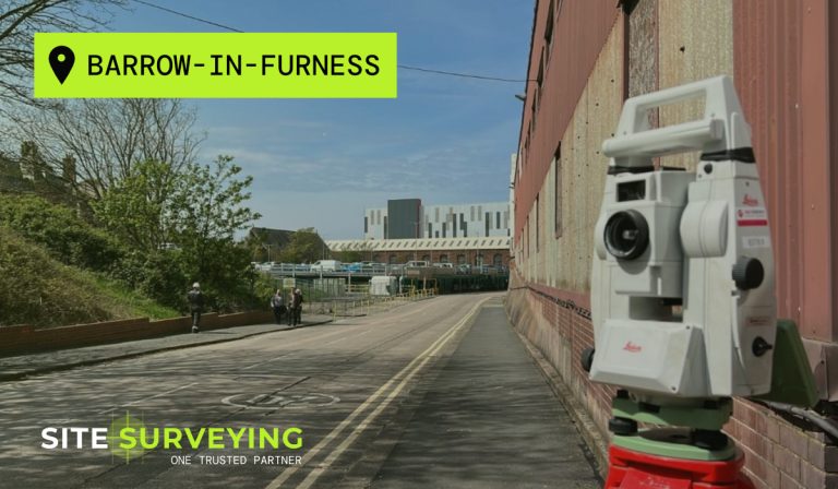
BAE Systems at Warton and Samlesbury, and at Barrow-in-Furness, represent the most significant defence manufacturing concentration in the UK outside of the South East. Survey on these sites requires security clearance, escort, method statement approval and compliant working practices — all of which our team has direct, documented experience of.
Food and drink production
Lancashire and the wider North West has a significant food and drink manufacturing sector. Surveys on food production sites require hygiene compliance, restricted access and working practices that protect the production environment. Our team is experienced in food site working requirements.
Chemical and process plant
process plant survey requires permit-to-work compliance, potentially ATEX-rated equipment in hazardous area zones and close coordination with the site’s HSE team. We produce method statements and risk assessments that reflect the specific hazard profile of each process plant survey.
Cold store and temperature-controlled logistics
survey in cold store and refrigerated logistics environments requires adapted working practices — equipment that functions at low temperatures, personnel rotations and condensation management for scanning in environments as cold as -25°C.
Project Types We Support
Project Types We Support
Manufacturing plant survey
as-existing laser scanning and measured building survey of manufacturing facilities for refurbishment design, plant rearrangement, structural assessment and regulatory compliance. SLAM scanning for large internal spaces where static scan positions would be impractical. Point cloud data delivered in the format your design software requires.
Process plant as-built survey
detailed laser scanning of process plant, pipework, equipment, vessels, steelwork and all structural elements for plant modification, expansion and decommissioning. The survey that tells the process engineer exactly what is there — and where everything is — before any design work begins.
Logistics and warehousing survey
measured building surveys of warehouse and logistics facilities for fit-out design, mezzanine floor addition, fire compartmentation assessment and building condition records. UAV survey for very large single-storey facilities where the roof and external site need to be captured efficiently.
Industrial new build and extension
topographic survey, PAS 128 utility mapping, control network, setting-out engineers and as-built survey for industrial new build and extension programmes across the North West.
Cold store and temperature-controlled facility survey
laser scanning in cold store and refrigerated environments, with adapted working practices and equipment management for low-temperature survey conditions.
Food production facility survey
measured building surveys and laser scanning on food production sites — hygiene compliance, restricted access methodology and working practices that protect the production environment.
Industrial site topographic survey
ground levels, site boundaries, drainage, hardstanding, access routes, external structures and all external features across industrial site areas. Pre-construction topographic survey for industrial development.
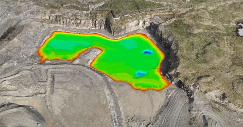
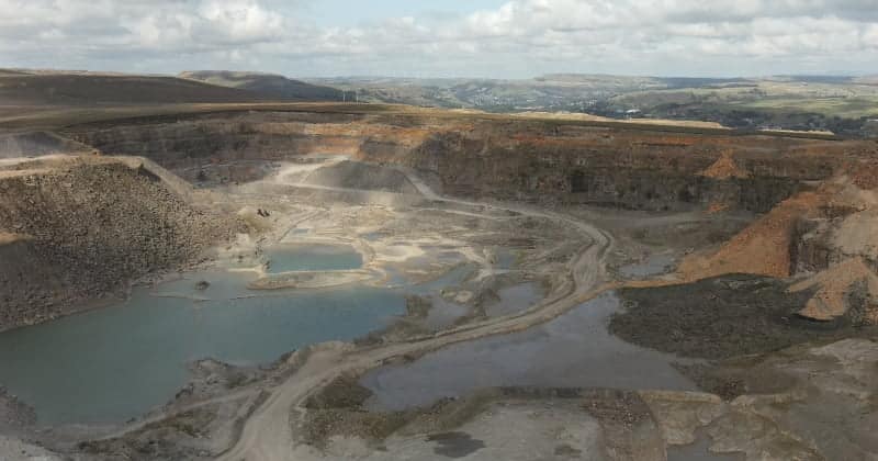
Quarry and aggregate site survey
UAV volumetric survey for stockpile and quarry face measurement, progress tracking and commercial reconciliation. Safe, rapid and accurate — without requiring personnel in the quarry face.
Industrial heritage and mill survey
measured building surveys and laser scanning of former industrial buildings — mills, factories, warehouses — for conversion, heritage recording and planning applications.
Who We Work With in the Industrial & Logistics Sector
Who We Work With in the Industrial & Logistics Sector
Manufacturing plant managers and facilities directors
Commissioning as-existing laser scan surveys for refurbishment design, plant rearrangement, health and safety assessment and regulatory compliance documentation.
Industrial property developers and REIT asset managers
Topographic survey, measured building survey and as-built survey for industrial and logistics property development, acquisition, fit-out and disposal.
Process plant engineers and chemical engineers
As-existing survey of process plant, pipework, equipment and structural fabric for plant modification, expansion and decommissioning design.
Logistics and warehousing operators
Building condition surveys, mezzanine floor assessment surveys and fit-out surveys for operational logistics facilities.
Industrial contractors
PAS 128 utility mapping before any groundworks, setting-out engineers for industrial building construction and extension, control network installation and as-built survey.
Defence prime contractors and their supply chains
Survey on MOD and defence manufacturing sites requiring security clearance, escorted access and compliant working practices. Our BAE Systems case study is the direct proof.
Food and drink manufacturers
Measured building surveys and laser scanning on food production facilities requiring hygiene compliance and restricted access methodology.
Our Services
Using LiDAR, UAVs, and hydrographic drones to capture precise data in challenging environments.
Topographical Surveys
OS-controlled accurate, efficient and cost effective surveys for highways, civils and development. Cad and BIM-ready output.
PAS 128 utility mapping
Providing the location of underground services in 2D or 3D through qualified utility mapping surveys, using advanced GPR and Electromagnetic Location.
Measured building survey
Delivering accurate as-built information that supports design, refurbishment, planning and construction with the latest technology. Producing reliable drawings and digital models.
Laser Scanning
3D laser scanners capture millions of points per second, creating a point cloud which enables the finer details and the physical site to be viewed remotely.
Mobile mapping
For highway engineers, infrastructure managers, local authorities and contractors working on live road schemes, mobile mapping is now the standard for corridor surveys.
3D Machine control
With decades of supporting major earthworks contractors and large-scale infrastructure schemes, we provide reliable machine control across Lancashire and the wider UK.
Setting out engineers
With strong, long-standing relationships across the civil engineering and construction sector, we supply skilled professionals who keep your projects accurate, efficient and on programme.
bathymetric surveys & river surveys
Using modern technology, we capture detailed underwater and river channel information safely and efficiently – delivering reliable data you can trust.
Stockpile surveys & volumetric analysis
Whether a one-off stockpile measurement or regular monitoring, we deliver reliable, repeatable data tailored to your project using advanced technology.
Control Network Installation
Delivering robust and precise site control systems to support every stage of construction in developments, infrastructure schemes or major earthworks.
aerial & drone surveys
CAA-approved drone operations for aerial mapping, photogrammetry and volumetric analysis, providing a comprehensive view of terrain, structures and landscapes.
3D BIM Modelling
Whether you require an as-built Revit model, federated coordination model or detailed digital twin, our team delivers high quality, design-ready outputs.
survey equipment hire
We offer a vast range of surveying and engineering equipment for hire and will always try to beat a comparable quote. Discover the fleet.
monitoring
Providing reliable monitoring surveys across the UK, delivering precise data that supports risk management, compliance and informed decision making throughout a project lifecycle.
Virtual Tour 3D
An immersive experience which instantly transports your clients to your business, guiding them through your space and creating a seamless experience.
Impermeable area surveys
We deliver georeferenced impermeable area data that drainage engineers and planning consultants can work from directly.
CCTV & Drainage surveys
Acoustic & Noise Assessments
We deliver acoustic and noise assessments, supporting planning applications, discharge of conditions and Environmental Impact Assessments.
Topographical Surveys
PAS 128 utility mapping
Laser Scanning
Mobile mapping
Setting out engineers
bathymetric surveys & river surveys
Control Network Installation
aerial & drone surveys
survey equipment hire
monitoring
Impermeable area surveys
CCTV & Drainage surveys
3D Machine control
Acoustic & Noise Assessments
Stockpile surveys & volumetric analysis
3D BIM Modelling
3D BIM Modelling
Virtual Tour 3D
Why choose site surveying services
On site. On spec. On time.
SLAM scanning. No production stoppage.
The CHC RS10 SLAM scanner moves through the live industrial environment capturing data continuously — without requiring production to stop.
Method statements industrial teams approve.
Written for the specific site, the specific hazard profile, the specific access constraints and the permit-to-work requirements of that facility.
BAE Systems. Whitworth Quarry. The industrial track record.
Live MOD industrial facility. Active quarry. Live food production. The environments where our methodology has been tested.
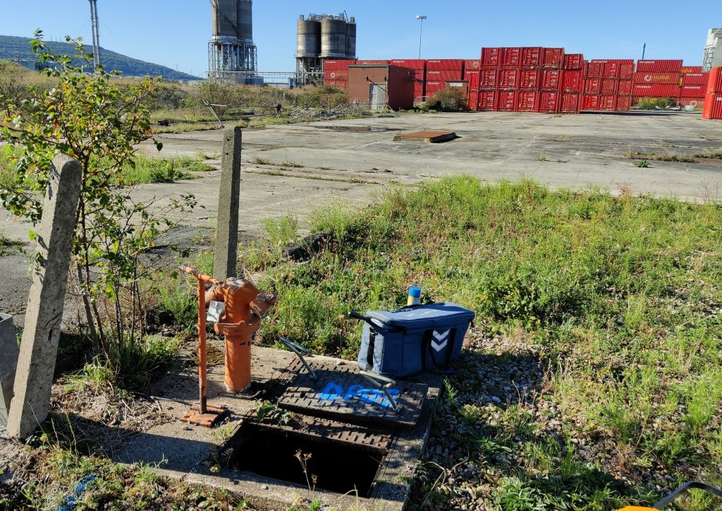
PAS 128 on service-dense industrial sites.
Decades of service modifications, decommissioned runs and undocumented crossings — the buried infrastructure risk profile of every active industrial site.
Frequently Asked Questions
Frequently Asked Questions
Can you survey a live operational manufacturing facility without stopping production?
Yes — and this is one of the primary reasons laser scanning and SLAM scanning have become the standard methodology for industrial facility survey. Static laser scanning captures the complete geometry of a space from each setup position without requiring anything in the space to stop moving. SLAM scanning allows the surveyor to walk through the live facility capturing data continuously. Both methodologies are designed to work around live operations — plant running, forklifts moving, personnel working — rather than requiring the facility to stop. We coordinate with the facilities manager to identify any areas where temporary exclusion is required for safety during scanning, but production stoppages are not a requirement of the survey methodology.
What is SLAM scanning and when is it used instead of static laser scanning?
SLAM (Simultaneous Localisation and Mapping) scanning uses a mobile scanner — carried by the surveyor — that continuously maps the environment and tracks its own position within it without requiring fixed setup points. It is faster in large, complex industrial spaces than static TLS and does not require the same number of individual scan positions. We use SLAM scanning — specifically the CHC RS10 — for large warehouse and production hall survey where the speed of capture matters and the facility cannot accommodate extended static setups at multiple positions. We use static TLS (Trimble X7) where higher point density and accuracy is required — for detailed structural elements, process plant and areas where precise dimensional data is critical. In practice, most industrial facility surveys use both methodologies in combination.
What survey does a process plant expansion or modification require?
Before any process plant modification or expansion can be designed, an accurate as-existing record of the plant is needed — the position, dimensions and connections of all existing equipment, pipework, vessels, steelwork and structural elements within the works area. Laser scanning captures this from the live plant — producing a dense point cloud that the process engineer can work from in 3D without returning to site for measurements. For plants in potentially explosive atmosphere (ATEX) zones, equipment used in the survey must be appropriately rated — we address this in the method statement for each process plant survey.
Do you hold ATEX-compliant equipment for hazardous area survey?
This depends on the specific zone classification and the survey equipment required. We advise on ATEX requirements at the time of scoping for each process plant or chemical facility survey and confirm which equipment is appropriate for the zone classification of the survey area. Where the survey area is classified as Zone 1 or Zone 2 and standard survey equipment is not appropriate, we adapt the methodology accordingly and confirm the approach with the site’s HSE team as part of the method statement process.
What hygiene standards do you comply with for food production facility survey?
This depends on the specific requirements of the facility. We comply with whatever hygiene standard the food production site’s management team requires — personal protective equipment, equipment cleaning and decontamination, restricted access areas and food safety protocols — as documented in the site-specific method statement and risk assessment produced before the survey. We have surveyed food production facilities in the North West and are experienced in the hygiene compliance requirements these sites impose.
Can you survey cold store and refrigerated logistics facilities?
Yes. Cold store survey requires adapted working practices — personnel rotation through the cold environment, equipment management to prevent condensation damage and battery performance management at low temperatures. We plan cold store surveys with appropriate rotation schedules and equipment management protocols. Laser scanning works effectively in cold store environments and produces accurate results regardless of the ambient temperature.
What PAS 128 quality level is required before groundworks on an industrial site?
Quality Level A — physical verification of every service — is the appropriate standard before any groundworks on a live industrial site with a significant operational history. Industrial sites carry the highest risk of undocumented buried services of any site type — decades of service modifications, decommissioned runs abandoned in place, and cross-connections between systems that do not appear on any drawing. On a process plant or manufacturing site, an unplanned service strike could stop production, trigger an environmental incident or endanger personnel. Physical verification before excavation is not a specification question — it is the minimum standard that protects the programme.
Do you cover quarry and aggregate site survey?
Yes. UAV volumetric survey for quarry and aggregate sites is one of our most regularly commissioned industrial survey services — particularly for operators who need regular stockpile and quarry face measurement for commercial reconciliation without requiring personnel near the active extraction area. Our Whitworth Quarry case study demonstrates this capability directly.