


 Leeds
Leeds Doncaster
 Sheffield
 Bradford
 Hull
Hull Halifax
 Sunderland
 Newcastle
 Middlesborough
 Yorkshire Moors
 Teesside
 Cumbria
 Harrogate
 York
York Yorkshire Dales
 Northumberland
 Goole
Goole Carlisle
 Keswick
 Kendal
 Barrow-in-Furness
 Lancaster
 Blackpool
 Morecambe
 Southport
 Liverpool
 Wigan
Wigan Manchester
 Blackburn
 Burnley
 Forest of Bowland
 Oldham
 Chester
 Stockport
 Peak District
 Skipton
 Crewe
Crewe Rotherham
 Stoke
Stoke Driffield
Surveying Services North West
Site Surveying Services in Manchester & Greater Manchester
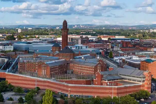
Manchester is the engine of the North — a city of extraordinary ambition, world-class heritage, and relentless development activity. From the historic grandeur of its Grade I listed civic buildings to the canal-side conversions of its industrial legacy, the towers rising across the city centre, and the network of regeneration programmes reshaping its neighbourhoods, Manchester presents surveyors with as rich and varied a workload as anywhere in the UK.
Site Surveying Services has delivered professional surveying projects across Manchester and Greater Manchester, taking on some of the city’s most demanding and prestigious commissions — including heritage scanning work at Manchester Town Hall, one of the finest Victorian Gothic buildings in England. We work across the full spectrum of Manchester’s development activity: from public sector heritage conservation to commercial measured surveys, canal-side scanning, community facilities, and large-scale topographic programmes.
Based in Clitheroe — under an hour from Manchester city centre — we offer the responsiveness of a local firm with the technology, accreditation, and track record of a national specialist.
Our Surveying Services in Manchester
We offer a comprehensive range of professional surveying services to clients across Manchester and Greater Manchester:

3D Laser Scanning Manchester
high-density point cloud surveys using Trimble X7 and Leica RTC360 for heritage buildings, industrial structures, canal-side properties, and complex commercial buildings
Topographic Surveys Manchester
detailed land and site surveys for planning applications, drainage design, flood risk, and development across Greater Manchester
Measured Building Surveys Manchester
precise floor plans, elevations, and sections for heritage assets, commercial properties, education buildings, and residential conversions
Matterport Scanning Manchester
immersive 3D virtual walk-throughs for asset management, marketing, and documentation
Sectors We Serve in Manchester
Our project experience across Manchester covers the full breadth of the city’s development and conservation activity:
Heritage & Conservation Manchester
laser scanning and measured surveys of Manchester's exceptional stock of Grade I and Grade II listed buildings
Commercial & Mixed-Use Manchester
surveys supporting the city's ongoing commercial development, refurbishment, and mixed-use regeneration
Education & Community Manchester
measured building surveys and laser scanning for schools, youth centres, and community facilities
Canal & Waterway Manchester
scanning and surveys along Manchester's historic canal network
Infrastructure & Public Realm Manchester
topographic surveys for highways, utilities, and public realm schemes across Greater Manchester
Residential Development Manchester
surveys for new-build and conversion residential schemes across the city and its boroughs
Public Sector Manchester
surveys for Manchester City Council, local authorities, and their partners
Surveying Case Studies & Project Highlights in Manchester
Case Studies & Project Highlights
Manchester Town Hall — Measured Building Survey (Grade I Listed)
Manchester Town Hall is one of the finest examples of Gothic Revival architecture in the country — a Grade I listed masterpiece designed by Alfred Waterhouse, opened in 1877, and one of the most celebrated civic buildings in England. It is currently undergoing one of the most significant heritage restoration programmes in the UK, returning it to its original Victorian splendour while bringing it up to modern safety and accessibility standards.
Our commission, for Gariff Construction, was a technically demanding and historically significant one: to produce highly accurate and detailed drawings of the entrance doors using the Trimble X7 laser scanner, as part of the process of removing, reinforcing with bomb-proofing measures, and replacing the historic doors precisely to their original specifications. The task demanded meticulous attention. The Grade I listed status of the building meant that every modification had to respect the heritage and architectural significance of the doors absolutely — and that required survey data of exceptional precision. The Trimble X7’s high-resolution 3D scanning technology enabled our team to capture every intricate detail of the historic entrance doors: from the smallest carved decorative elements to the overall structural geometry, ensuring that the replacement doors could be fabricated and reinstalled to precisely match the originals.
The ten days of post-processing in the office reflect the care and complexity involved in translating highly detailed scan data into drawings precise enough to guide heritage restoration of this calibre. The result: survey data that supported the preservation of Manchester Town Hall’s historical integrity while allowing modern safety requirements to be met without compromise.
Client details
Gariff Construction
service provided
Measured Building Survey / 3D Laser Scanning
Project timeline
2 days on site / approx. 10 days in the office
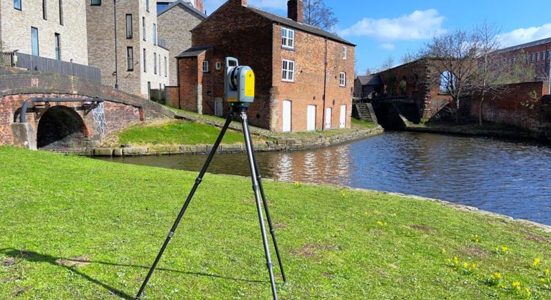
Canalside Measured Survey, Manchester
3D Laser Scanning / Measured Building Survey
Manchester’s canal network is one of the city’s great built assets — a ribbon of industrial heritage threading through the urban fabric, lined with former warehouses, mills, and canal-side structures many of which are now undergoing conversion and restoration. Our team carried out a measured survey at a canalside property in Manchester using the Trimble X7, delivering a completed and issued survey in no time at all — a reminder that speed and quality are not mutually exclusive when the right technology and team are deployed.
Topography, Measured Building Survey & Matterport, Manchester
Topographic Survey, Measured Building Survey & Matterport Scan
A comprehensive multi-discipline commission wrapping up a full week’s work in Manchester — combining a topographic survey, measured building survey, and Matterport scanning for one of our clients. The Matterport scan delivers a fully immersive 3D virtual model of the building’s interior, complementing the measured drawing output and providing the client with a digital record that goes beyond traditional 2D drawings. Delivered and issued efficiently at the end of the week, with the team already fully integrated and ready for the next project.
Youth Centre, Manchester — Measured Building Survey
Measured Building Survey / 3D Laser Scanning (RTC360)
Laser scanning at a Manchester Youth Centre, capturing the building’s full interior and exterior geometry with the Leica RTC360. Community buildings of this type — sports halls, activity spaces, multi-use community facilities — present their own surveying challenges, with complex multi-level floor plates, large open spaces, and the need to work around ongoing activities. Our team surveyed from centre court level using the RTC360, capturing comprehensive data to support the production of detailed building drawings.
Trafford Road Cycle Lane Improvement Scheme — Setting Out
Setting Out
An ongoing setting out commission on the Trafford Road Cycle Lane Improvement Scheme — kerbing out on a live active travel infrastructure project in Salford/Trafford, one of many sites our teams visit repeatedly throughout the duration of a programme. Setting out on infrastructure schemes like this requires absolute clarity in how positions are marked and communicated: our site operatives ensure that every contractor on site understands precisely what has been set out and what they need to do with it. Hundreds of sites a year, some visited once, others multiple times from start to finish — this is the bread and butter of infrastructure survey support across Greater Manchester.
Manchester's Development Landscape
Manchester's Development Landscape
Manchester is the UK’s most significant economic centre outside London — a city of relentless development activity, ambitious housing programmes, and sustained commercial and cultural investment. The Greater Manchester Places for Everyone Joint Development Plan, adopted in 2024, sets the strategic planning framework for nine GM authorities through to 2039, targeting 3,533 new homes per year across the conurbation.
Manchester City Council is currently preparing a new city-specific Local Plan to replace the existing Core Strategy (adopted 2012), with a draft plan now in consultation and adoption expected by summer 2027. The new plan proposes expanding the city centre boundary, increasing affordable housing requirements, and setting policies to guide Manchester’s growth as one of Europe’s most ambitious urban development environments.
Why Choose Site Surveying Services in Manchester?
Why Choose Site Surveying Services in Manchester?
Grade I heritage specialists
Manchester Town Hall is one of the most prestigious heritage survey commissions available; we delivered it with the precision and care it demanded
Advanced scanning technology
Trimble X7 and Leica RTC360 delivering high-resolution data for heritage, commercial, and community buildings
Multi-discipline delivery
topographic, measured building, laser scanning, Matterport, and utility surveys combined in a single efficient commission
Canal and waterway experience
regular survey work in and around Manchester's historic canal network
Under an hour from Clitheroe
fast mobilisation, local presence, competitive pricing
Trusted by construction and heritage contractors
working with clients including Gariff Construction on some of Manchester's most significant projects
Frequently Asked Questions
Frequently Asked Questions
Do you carry out laser scanning of listed buildings in Manchester?
Yes — and Manchester Town Hall is our flagship example. We have the technology, methodology, and heritage sensitivity to survey Grade I and Grade II listed buildings accurately, with the level of detail that conservation and restoration programmes require. The Trimble X7 is particularly well suited to heritage scanning, capturing intricate architectural details with exceptional precision.
Can you carry out surveys at Manchester Town Hall or similar heritage buildings?
Yes. Our work at Manchester Town Hall for Gariff Construction — producing detailed drawings of the historic entrance doors to support their removal, bomb-proofing, and reinstatement — demonstrates exactly our capability on heritage restoration commissions of the highest sensitivity. We understand the requirements of Grade I listed buildings and the standards expected when working on them.
Do you offer Matterport scanning in Manchester?
Yes. Matterport scanning produces immersive, navigable 3D virtual models of building interiors, ideal for asset management, marketing, planning, and building documentation. We can combine Matterport with measured building surveys and laser scanning in a single visit.
Can you survey canalside and waterway properties in Manchester?
Yes — and we do so regularly. Manchester’s canal network is lined with former industrial buildings undergoing conversion, and our laser scanning and measured building survey capability is well suited to the complex geometries and access constraints these properties often present.
Do you carry out topographic surveys for planning applications in Greater Manchester?
Yes. We provide topographic surveys across Manchester and the wider Greater Manchester area to support planning applications, drainage design, flood risk assessments, and development appraisals. All outputs are produced to planning specification and delivered in CAD or other agreed formats.
How quickly can you get to Manchester from your base?
Our Clitheroe base puts us less than an hour from Manchester city centre in normal conditions. For most project types we can mobilise within 24–48 hours of instruction, and we can often accommodate same-week requirements for straightforward commissions.