


 Leeds
Leeds Doncaster
 Sheffield
 Bradford
 Hull
Hull Halifax
 Sunderland
 Newcastle
 Middlesborough
 Yorkshire Moors
 Teesside
 Cumbria
 Harrogate
 York
York Yorkshire Dales
 Northumberland
 Goole
Goole Carlisle
 Keswick
 Kendal
 Barrow-in-Furness
 Lancaster
 Blackpool
 Morecambe
 Southport
 Liverpool
 Wigan
Wigan Manchester
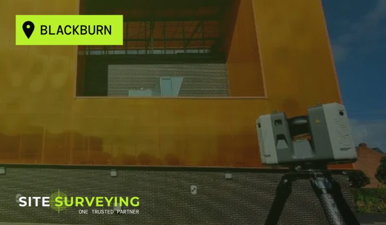
 Blackburn
 Burnley
 Forest of Bowland
 Oldham
 Chester
 Stockport
 Peak District
 Skipton
 Crewe
Crewe Rotherham
 Stoke
Stoke Driffield
Ensuring compliance, safety and value for communities.
Public Sector & Service Surveying
Public sector buildings carry a different kind of accountability. A school extension built on inadequate survey data affects children’s education. A hospital refurbishment delayed by a utility strike disrupts patient care. A civic building whose measured building survey missed a structural feature creates a planning dispute that costs a local authority money it cannot easily recover. These are not abstract consequences — they happen when the survey was wrong, under-specified or not commissioned early enough.Site Surveying Services has delivered survey across the public sector in Lancashire and the North West for nearly three decades. From special educational needs schools in Blackpool to fire stations in Greater Manchester, from civic buildings in Preston to universities in Clitheroe and beyond — we understand what public sector clients need from a survey firm. Accreditations that satisfy public procurement frameworks. An in-house team that can be held accountable. Data delivered in the format the design team and the planning authority require. And a working method that causes minimum disruption to the people using the buildings we are surveying.
Surveying for Service Projects
Surveying for Service Projects
tight constraints, strict budgets, complex procurement processes, and the need to balance cost efficiency with public accountability. From healthcare facilities to transport hubs and educational campuses, every project must meet demanding standards for safety, sustainability, and accessibility. Local authorities and public bodies need survey partners who combine technical precision, proven reliability, and a collaborative approach, ensuring projects are delivered right the first time, every time.
Why Accuracy Matters...
Precise data is the foundation for creating environments that support care, learning, and community wellbeing. With reliable survey information, clients can:
Projects meet compliance and safety standards
essential for government-funded schemes.
Designs are efficient and sustainable
maximising public investment through better resource use.
Procurement runs smoothly
with verified data supporting feasibility, design, and construction tenders.
Maintenance is simplified
through detailed, long-term datasets that support future upgrades and facility management.
Public disruption is minimised
with accurate, efficient surveying reducing site time and repeat visits.
Innovation in Action
Innovation in Action
The Public Sector in Lancashire and the North West
The Public Sector in Lancashire and the North West
Public sector survey demand across the North West is active and growing across several distinct investment programmes:
Education capital investment
School condition surveys, RAAC remediation programmes, academy trust expansion and new school construction are all generating sustained demand for measured building survey, topographic survey and laser scanning across Lancashire, Greater Manchester and Cumbria. The free school programme and university campus expansion add to this.
NHS estate backlog
The NHS estate in the North West carries significant backlog maintenance liability. Trust estate managers and their appointed contractors require measured building surveys, laser scanning and PAS 128 utility mapping to support refurbishment, new build and estate consolidation programmes across hospital sites, GP surgeries, mental health facilities and community health infrastructure.
Local authority infrastructure
Lancashire County Council, the Greater Manchester Combined Authority and the district councils across the North West all commission survey on highways programmes, public realm improvements, parks and green space, civic buildings and council housing estates. Constructionline Gold accreditation — which we hold — is the standard pre-qualification requirement for local authority supply chains.
Emergency services
Fire stations, police stations, ambulance hubs and coastguard facilities across the North West all require periodic survey for refurbishment, extension and estate management programmes. These are operationally sensitive environments where the survey methodology must work around shift patterns, equipment deployment schedules and emergency readiness.
Active travel and transport
Sustained active travel investment across the North West is generating highway corridor survey, junction survey and transport assessment survey demand. Our mobile mapping capability is directly applicable to this programme.
Who We Work With in the Public Sector
Who We Work With in the Public Sector
Local authorities and councils
Lancashire County Council, Greater Manchester authorities, district and borough councils commissioning survey for highways, public realm, civic buildings, council housing and green infrastructure.
NHS and healthcare estates teams
Trust estates managers, NHS Property Services and their appointed contractors commissioning measured building surveys, PAS 128 utility mapping and topographic survey across hospital and community health sites.
Academy trusts and local authority education departments
Emergency services
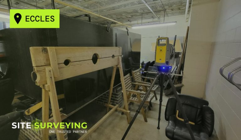
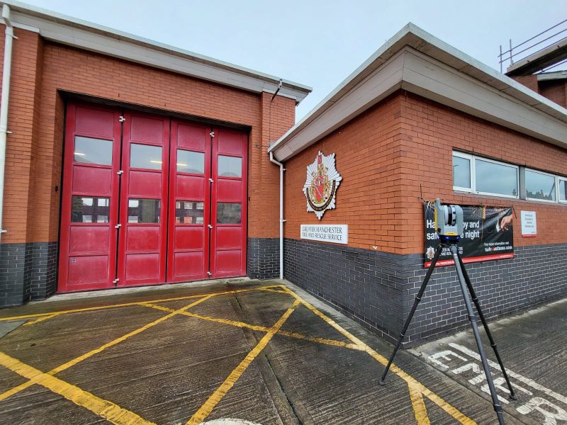
Greater Manchester Fire & Rescue Service, Lancashire Constabulary, North West Ambulance Service and their appointed contractors — as demonstrated by our Eccles Fire Station project.
Universities and further education colleges
UCLan, Blackpool and the Fylde College and other NW higher and further education institutions commissioning campus survey for refurbishment and development.
Government estate teams
Central government departments and their supply chain contractors commissioning survey across the government estate in the North West.
Sports and leisure operators
Local authority leisure centres, sports facilities and parks departments. Premier League standard facilities to grassroots community sport — our 2025 work at a Premier League training ground demonstrates the range.
Where We Work in the Public Sector
Where We Work in the Public Sector
Schools and education facilities
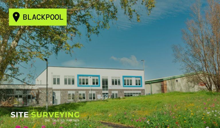
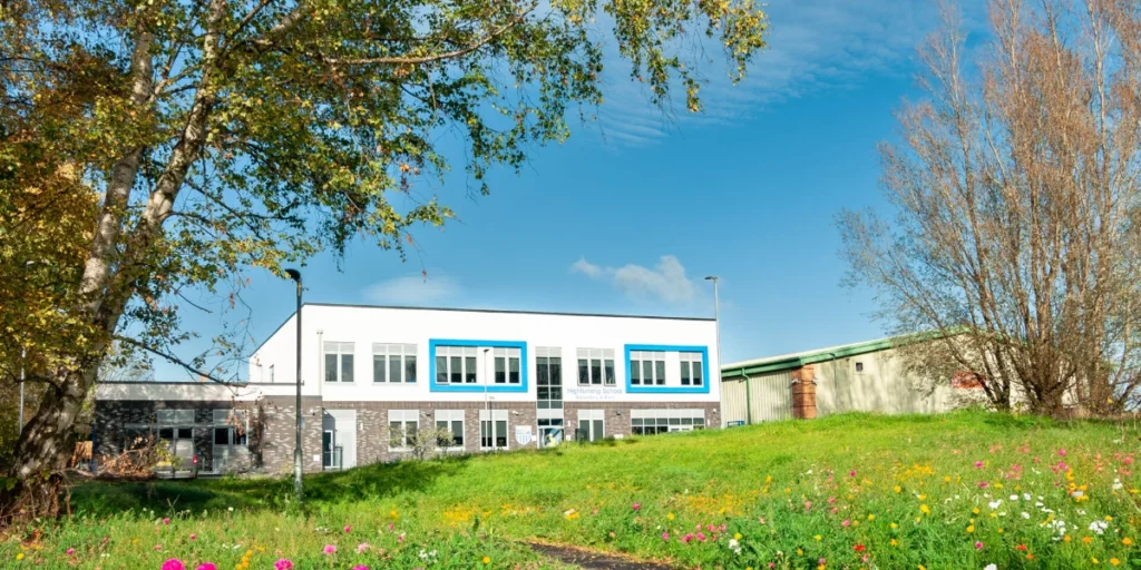
Measured building surveys for refurbishment and extension, RAAC assessment support surveys, topographic surveys for new school development on greenfield and brownfield sites, laser scanning for complex or listed school buildings. High Furlong School in Blackpool is a direct example — a specialist SEND school where the survey environment required particular care and sensitivity.
Healthcare and NHS estates
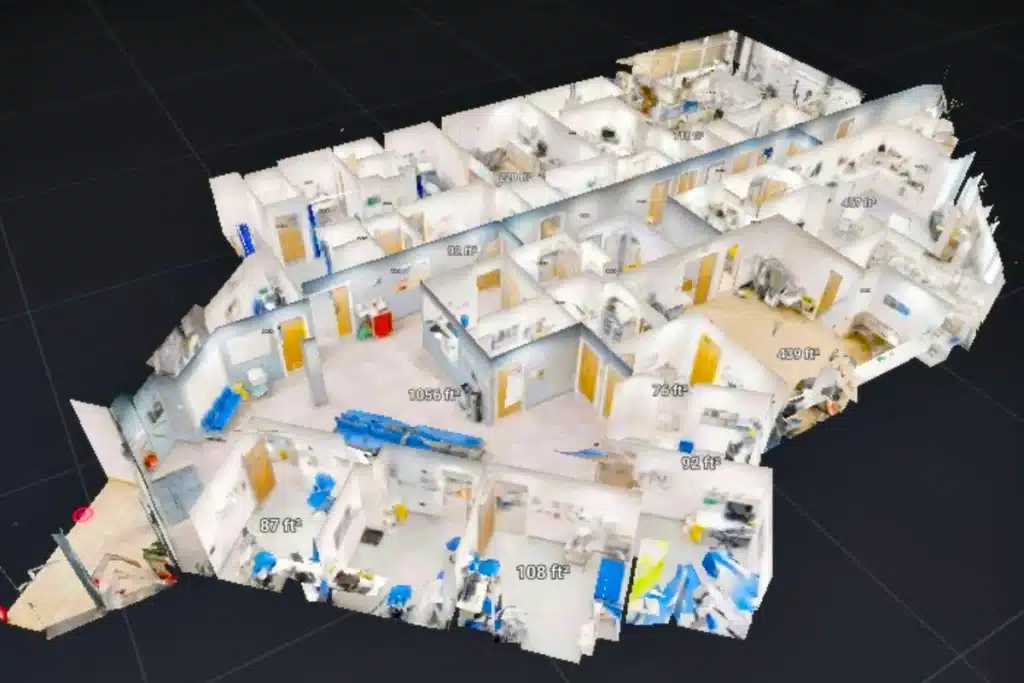
Measured building surveys across occupied hospital wards and clinical environments, PAS 128 utility mapping before any groundworks on healthcare sites, topographic survey for new healthcare facilities, laser scanning for complex building geometry in operating or occupied clinical spaces.
Civic and council buildings
Libraries, town halls, civic centres, council offices, community centres and public amenity buildings. Measured building surveys, topographic surveys, laser scanning and BIM models for refurbishment and estate management.
Emergency services infrastructure
Fire stations, police stations, ambulance stations and coastguard facilities. Survey in live operational environments — working around shift patterns, vehicle deployment schedules and emergency readiness. Our Eccles Fire Station case study is the clearest demonstration of this capability.
Active transport and public highways
Highway corridor survey using mobile mapping and topographic methods for active travel route design, public realm improvement and transport assessment. Setting-out support for council-commissioned highway works.
Universities and FE colleges
Campus topographic survey, measured building surveys for refurbishment, laser scanning for complex university buildings, UAV survey for large campus areas.
Social housing and regeneration
Topographic and measured building surveys for housing association and council housing refurbishment, regeneration and new development across East Lancashire and the wider North West.
Public parks and green infrastructure
Topographic and boundary survey for parks, recreation grounds, flood relief land and public green space management and improvement.
Sports and leisure facilities
Topographic surveys for sports facility development, measured building surveys for leisure centre refurbishment, UAV survey for large sports and recreational sites. Premier League training facility survey demonstrated in our 2025 case study.
Our Services
Topographical Surveys
OS-controlled accurate, efficient and cost effective surveys for highways, civils and development. Cad and BIM-ready output.
PAS 128 utility mapping
Providing the location of underground services in 2D or 3D through qualified utility mapping surveys, using advanced GPR and Electromagnetic Location.
Measured building survey
Delivering accurate as-built information that supports design, refurbishment, planning and construction with the latest technology. Producing reliable drawings and digital models.
Laser Scanning
3D laser scanners capture millions of points per second, creating a point cloud which enables the finer details and the physical site to be viewed remotely.
Mobile mapping
For highway engineers, infrastructure managers, local authorities and contractors working on live road schemes, mobile mapping is now the standard for corridor surveys.
3D Machine control
With decades of supporting major earthworks contractors and large-scale infrastructure schemes, we provide reliable machine control across Lancashire and the wider UK.
Setting out engineers
With strong, long-standing relationships across the civil engineering and construction sector, we supply skilled professionals who keep your projects accurate, efficient and on programme.
bathymetric surveys & river surveys
Using modern technology, we capture detailed underwater and river channel information safely and efficiently – delivering reliable data you can trust.
Stockpile surveys & volumetric analysis
Whether a one-off stockpile measurement or regular monitoring, we deliver reliable, repeatable data tailored to your project using advanced technology.
Control Network Installation
Delivering robust and precise site control systems to support every stage of construction in developments, infrastructure schemes or major earthworks.
aerial & drone surveys
CAA-approved drone operations for aerial mapping, photogrammetry and volumetric analysis, providing a comprehensive view of terrain, structures and landscapes.
3D BIM Modelling
Whether you require an as-built Revit model, federated coordination model or detailed digital twin, our team delivers high quality, design-ready outputs.
survey equipment hire
We offer a vast range of surveying and engineering equipment for hire and will always try to beat a comparable quote. Discover the fleet.
monitoring
Providing reliable monitoring surveys across the UK, delivering precise data that supports risk management, compliance and informed decision making throughout a project lifecycle.
Virtual Tour 3D
An immersive experience which instantly transports your clients to your business, guiding them through your space and creating a seamless experience.
Impermeable area surveys
We deliver georeferenced impermeable area data that drainage engineers and planning consultants can work from directly.
CCTV & Drainage surveys
Acoustic & Noise Assessments
We deliver acoustic and noise assessments, supporting planning applications, discharge of conditions and Environmental Impact Assessments.
Why choose site surveying services
On site. On spec. On time.
Social value. Local employment.
Pre-qualification for local authority, NHS and government estate supply chains — already satisfied. East Lancashire Hospice support. The social value credentials that public sector procurement increasingly requires.
Occupied buildings. Without disrupting the people.
Eccles Fire Station — zero callouts disrupted. High Furlong SEND School — zero disruption to the school day. The working method that surveys the building around the people, not the other way around.
RAAC support survey for education and healthcare.
The pre-assessment geometric record that structural engineers need for RAAC assessment programmes. Laser scanning of ceiling and roof geometry, structural bay dimensions and building fabric.
RICS regulated. CDM compliant. Fully insured.
The professional framework that public sector clients and their design teams require when survey data underpins planning, design and construction decisions on service, hospital and educational buildings.
Frequently Asked Questions
Frequently Asked Questions
What survey does a school refurbishment or extension require?
At a minimum, a measured building survey of the existing school building — floor plans, elevations, sections and ceiling heights — to give the architect and structural engineer the accurate existing conditions data the refurbishment design depends on. For an extension, a topographic survey of the school site — ground levels, boundaries, drainage, trees and access — is also required. Where any excavation is planned on the school site, PAS 128 utility mapping before groundworks. Where the school is a listed building or in a conservation area, the measured building survey specification may need to be extended to meet heritage planning requirements. We advise on the right survey scope for your specific school and project type at the time of enquiry.
What is a RAAC survey and can you help with it?
RAAC — Reinforced Autoclaved Aerated Concrete — was widely used in school and other public building construction between the 1950s and 1990s. Following the Department for Education’s RAAC assessment programme, many schools require survey support to establish the location, extent and condition of RAAC elements within their buildings. While structural assessment of RAAC is carried out by structural engineers rather than land surveyors, measured building survey and laser scanning from Site Surveying Services provides the accurate geometric record of the building that structural engineers need as the base for their RAAC assessment — including ceiling and roof geometry, structural bay dimensions and the building fabric detail that determines the assessment scope. We work alongside structural engineers on RAAC assessment programmes on request.
Can you survey an occupied school or hospital without disrupting operations?
Yes. Surveying occupied public buildings is one of our most common and most technically managed work types. We produce method statements that plan the survey around the operational requirements of the building — school hours, clinical sessions, shift patterns, emergency readiness. We coordinate with the facility manager before every visit and adapt the survey programme when operational priorities require it. High Furlong School and Eccles Fire Station are direct examples of this capability in occupied public sector environments.
Do you hold the right accreditations for local authority and NHS supply chains?
Yes. We hold Constructionline Gold, RICS regulation, PAS 128 accreditation, CDM 2015 compliance and CAA approval — the full accreditation profile required for local authority, NHS and government estate supply chains. All accreditations are current and can be evidenced immediately for procurement purposes. We are also registered on Builders Profile and hold Avetta accreditation.
What is the right survey for a local authority public realm improvement programme?
Public realm improvement — streetscaping, public space redesign, active travel routes, park improvement — typically requires a topographic survey of the existing site capturing ground levels, drainage, boundaries, street furniture, trees and all contextual features. For highway-related public realm on live carriageways, our mobile mapping capability captures the full corridor dataset at road speed with minimal traffic management. For larger sites including parks and open spaces, UAV survey combined with ground survey produces the most efficient and complete dataset. We advise on the right methodology for your specific public realm programme at the time of enquiry.
Can you provide a social value statement for public sector procurement?
Yes. We can provide a Social Value Statement document evidencing our contribution across employment, skills, community investment, supply chain ethics and environmental responsibility. We are a Lancashire business with a directly employed local team, active community partnerships — including East Lancashire Hospice and Blackburn Rovers Business Club — and a youth development programme that includes work experience placements, graduate development, CITB contributions and school and university engagement. Contact us to request the document.
What survey is required before groundworks on an NHS or school site?
PAS 128 utility mapping before any excavation — physically verified service positions, not desktop records. Public sector sites, particularly NHS campuses and older school buildings, frequently carry decades of buried infrastructure not fully represented in existing utility records. Quality Level A physical verification is the appropriate standard on occupied public sector sites where a service strike would affect clinical operations, educational programmes or public safety. CDM regulations require the principal designer to obtain pre-construction information — PAS 128 QLA is the standard that satisfies this requirement on public sector sites.