


 Leeds
Leeds Doncaster
 Sheffield
 Bradford
 Hull
Hull Halifax
 Sunderland
 Newcastle
 Middlesborough
 Yorkshire Moors
 Teesside
 Cumbria
 Harrogate
 York
York Yorkshire Dales
 Northumberland
 Goole
Goole Carlisle
 Keswick
 Kendal
 Barrow-in-Furness
 Lancaster
 Blackpool
 Morecambe
 Southport
 Liverpool
 Wigan
Wigan Manchester
 Blackburn
 Burnley
 Forest of Bowland
 Oldham
 Chester
 Stockport
 Peak District
 Skipton
 Crewe
Crewe Rotherham
 Stoke
Stoke Driffield
Surveying Services North West
Site Surveying Services in Salford, Greater Manchester
Salford is one of Greater Manchester’s most dynamic cities — a place that has undergone one of the most dramatic transformations of any urban centre in the North West over the past two decades. From the iconic MediaCityUK development at Salford Quays to the continued regeneration of its waterfront, town centre, and residential neighbourhoods, Salford’s built environment is in constant, purposeful motion. Major infrastructure investment, large-scale public realm schemes, and a pipeline of commercial and residential development make it one of the most active construction environments in the region.
Site Surveying Services has delivered professional surveying across Salford, working directly with tier 1 contractors on some of the city’s most significant live construction programmes. From setting out and infrastructure surveys at Salford Quays to point cloud surveys and Revit modelling in Salford’s characterful Victorian streetscape, our team has the technology, capability, and experience that Salford’s demanding construction environment requires.
Based in Clitheroe and well connected via the M60 and M602, we deliver accurate, timely survey data to clients across Salford and the wider Greater Manchester area.
Our Surveying Services in Salford
We offer a comprehensive range of professional surveying services to clients across Salford and Greater Manchester:

Setting Out Salford
precise construction setting out for public realm, infrastructure, and development projects, including on active live highway schemes alongside tier 1 contractors
Point Cloud Surveys Salford
high-density 3D laser scanning using Leica RTC360 for urban buildings, streetscapes, and complex structures
Revit Model Production Salford
detailed BIM models produced from point cloud data, for design, refurbishment, and asset management
Topographic Surveys Salford
detailed land and site surveys for planning, drainage, and development across Salford and the Greater Manchester conurbation
Sectors We Serve in Salford
Our Salford project experience covers the city’s distinctive mix of infrastructure, commercial, and regeneration activity:
Infrastructure & Public Realm Salford
setting out and survey support for major highway, footpath, and public realm improvement schemes
Commercial & Mixed-Use Salford
point cloud surveys and measured building surveys for commercial properties and mixed-use development
MediaCity & Waterfront Salford
surveys supporting the continued development and management of Salford Quays and the MediaCityUK waterfront
Residential Development Salford
topographic and utility surveys for housing schemes across Salford's active residential development pipeline
Heritage & Urban Fabric Salford
point cloud surveys of Salford's Victorian commercial and industrial buildings for refurbishment and conservation
Education & Public Sector Salford
surveys for public buildings, university estates, and community facilities across the city
Surveying Case Studies & Project Highlights in Salford
Case Studies & Project Highlights
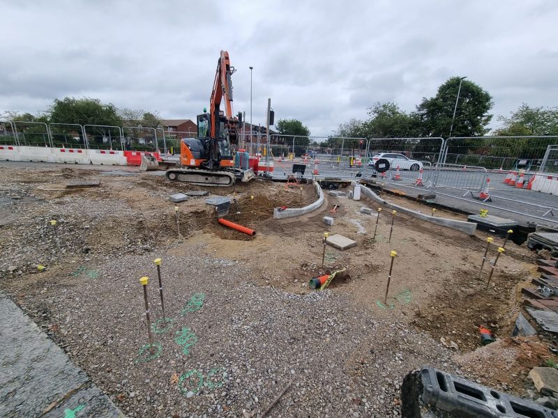
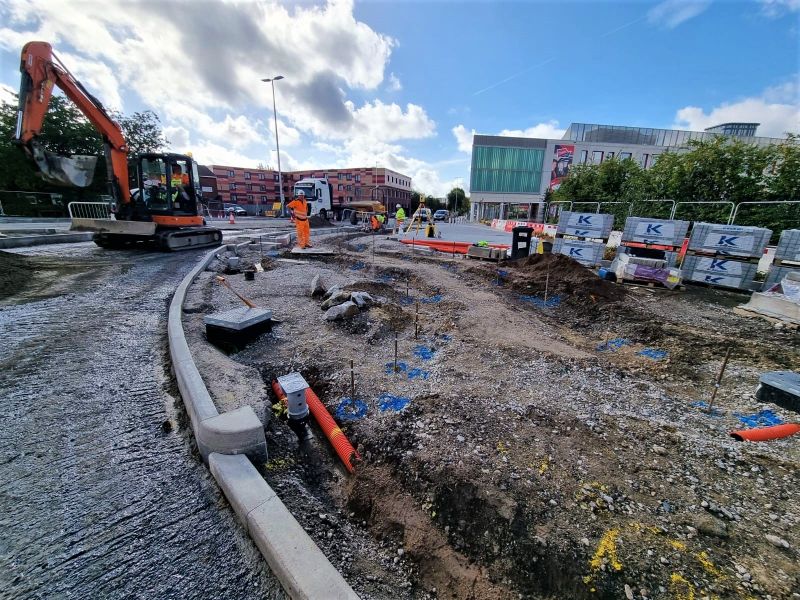
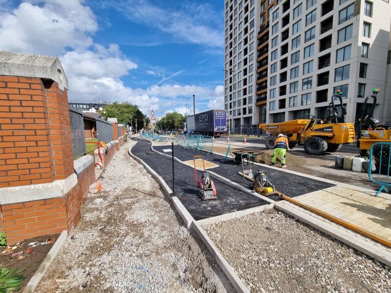
Salford Quays Public Realm — Setting Out for John Sisk & Son Ltd
An ongoing setting out commission at Salford Quays, delivered for John Sisk & Son Ltd — one of the UK and Ireland’s leading tier 1 construction contractors. Our team provided kerbing out and setting out services for a major public realm scheme at Salford Quays, with new footpaths taking shape across the site as works progressed. Working on live, active construction programmes of this scale alongside a tier 1 contractor demands precision, reliability, and clear communication — our site operatives ensure that every position is accurately marked and every contractor on site understands exactly what has been set out and what they need to do next. The sun even made an appearance. As we say: it’s not always grim up north.
John Sisk & Son Ltd
Gariff Construction
service provided
Setting Out
Point Cloud Survey & Revit Model, Salford
A point cloud survey on a beautiful day in Salford’s characterful Victorian streetscape — deploying the Leica RTC360 and Phantom 4 Pro RTK drone in combination to capture every detail of the building and its urban context. The dual-instrument approach is particularly valuable in dense urban environments like Salford’s city centre, where tall buildings, overhead structures, and narrow streets can restrict ground-level scanner views. The Phantom 4 Pro RTK filled those gaps from above, ensuring comprehensive coverage that the office team could use to produce a highly detailed Revit Model — with no blind spots and no return visits needed. The resulting Revit model gives the client a precise, BIM-ready digital record of the building, usable across design, planning, refurbishment, and asset management workflows.
Point Cloud Survey & Revit Model Production
Setting Out
Salford's Development Landscape
Salford's Development Landscape
Why Choose Site Surveying Services in Salford?
Why Choose Site Surveying Services in Salford?
Tier 1 contractor trusted
delivering for John Sisk & Son Ltd on live Salford Quays infrastructure programmes demonstrates our capability at the highest levels of construction delivery
Leica RTC360 + Phantom 4 Pro RTK combination
ground-level scanning and precision drone survey working together to eliminate blind spots in complex urban environments
Revit model production
BIM-ready outputs from point cloud data, delivered to the specification your design and asset management teams need
Infrastructure setting out specialists
from kerbing out on busy public realm schemes to precise structural setting out, we deliver clarity on site
Fast mobilisation from Lancashire
well connected to Salford via M60/M602, typically within 24–48 hours of instruction
Competitive and reliable
in-house technology, experienced surveyors, transparent pricing
Frequently Asked Questions
Frequently Asked Questions
Do you work with tier 1 contractors on construction projects in Salford?
Do you carry out point cloud surveys and Revit modelling in Salford?
Can you carry out setting out on live public realm and highway schemes in Salford?
Yes. Setting out on live, active highway and public realm schemes requires careful coordination with site management, clear marking methodology, and surveyors who communicate precisely with contractors. Our Salford Quays work is a good example of how we deliver on exactly these requirements.
Do you carry out topographic surveys for planning applications in Salford?
Yes. We provide topographic surveys across Salford to support planning applications, drainage assessments, and development appraisals, delivered in CAD or other agreed formats to planning specification.
What is the Phantom 4 Pro RTK and how does it improve survey quality in Salford?
The Phantom 4 Pro RTK is a precision drone with integrated RTK (Real-Time Kinematic) GPS, providing centimetre-level positioning accuracy in the air. Combined with ground-level laser scanning, it allows us to capture building features and areas that are obscured from ground level — rooflines, upper floors, overhangs, and areas above street-level obstructions — ensuring that point cloud data is complete and the resulting Revit models are fully detailed.