


 Leeds
Leeds Doncaster
 Sheffield
 Bradford
 Hull
Hull Halifax
 Sunderland
 Newcastle
 Middlesborough
 Yorkshire Moors
 Teesside
 Cumbria
 Harrogate
 York
York Yorkshire Dales
 Northumberland
 Goole
Goole Carlisle
 Keswick
 Kendal
 Barrow-in-Furness
 Lancaster
 Blackpool
 Morecambe
 Southport
 Liverpool
 Wigan
Wigan Manchester
 Blackburn
 Burnley
 Forest of Bowland
 Oldham
 Chester
 Stockport
 Peak District
 Skipton
 Crewe
Crewe Rotherham
 Stoke
Stoke Driffield
Surveying Services North West
Site Surveying Services in Pendle & East Lancashire
Pendle and East Lancashire form a distinctive corridor of post-industrial towns, moorland landscapes, and rural communities stretching from the Yorkshire border to the M65 corridor — an area that combines deep textile heritage with a resilient modern economy spanning manufacturing, renewable energy, logistics, and a growing development pipeline across its towns and villages.
The borough of Pendle — home to Nelson, Colne, Barnoldswick, and Earby — sits at the heart of this landscape, and with a newly adopted Local Plan to 2040 now in place, the foundations are set for sustained development and regeneration investment across the borough. To the south and east, Hyndburn and Ribble Valley bring Accrington, Great Harwood, and the Ribble Valley fringe into the wider East Lancashire survey territory our teams cover.
Site Surveying Services is practically on the doorstep — based in Clitheroe, right on the Pendle borough boundary, we are as local as it gets for any project across this area. From factory scanning and utility mapping in Barnoldswick to monitoring campaigns on wind farm sites above Accrington and topographic surveys of Nelson’s waterways, our teams know East Lancashire’s varied landscape intimately.
Our Surveying Services in Pendle & East Lancashire
Monitoring Surveys & Campaigns in East Lancashire
periodic measurement and recording of ground and structural changes for wind energy, construction, mining, and infrastructure projects
Utility Surveys in East Lancashire
underground service detection and mapping using GPR and electromagnetic equipment, for factory sites, development land, and infrastructure projects
3D Laser Scanning in East Lancashire
high-density point cloud surveys for industrial and factory buildings, commercial properties, and heritage assets
Topographic Surveys in East Lancashire
detailed land and site surveys for planning applications, watercourse management, development, and infrastructure
Sectors We Serve in Pendle & East Lancashire
Our project experience across the area spans the full range of Pendle and East Lancashire’s industrial, environmental, and development activity:
Renewable Energy & Wind Farms in East Lancashire
monitoring campaigns and setting out surveys for wind energy installations on East Lancashire's moorland
Manufacturing & Industrial in East Lancashire
laser scanning and utility mapping for factory buildings and industrial sites across the Pendle and Hyndburn area
Water & Environment in East Lancashire
topographic surveys for watercourses, fishing lakes, and environmental management projects
Residential Development in East Lancashire
topographic and utility surveys for housing schemes across the borough's towns and villages
Infrastructure
setting out and monitoring surveys for energy, utilities, and civil engineering projects
Heritage & Conservation
surveys of East Lancashire's rich textile heritage buildings and town centre architecture
Surveying Case Studies & Project Highlights in Pendle and East Lancashire
Case Studies & Project Highlights
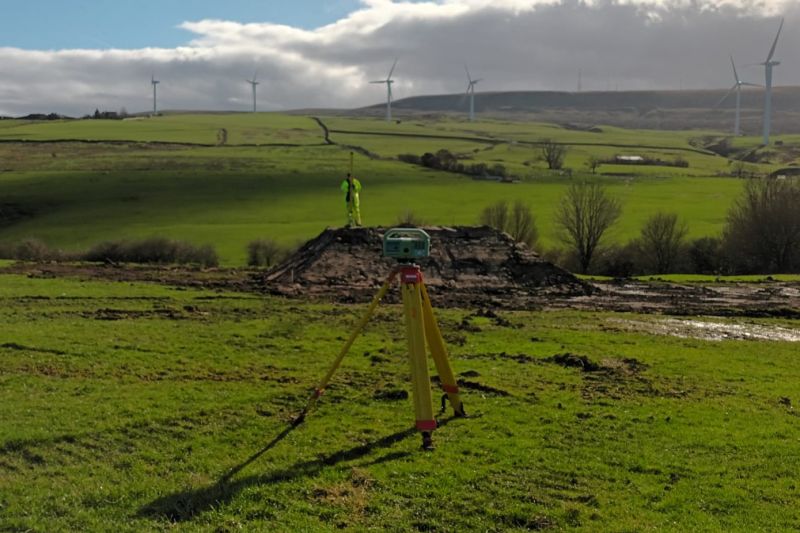
Monitoring Campaign & Setting Out, Accrington
Monitoring Campaign & Setting Out
A project that grew over time — beginning with a monitoring campaign above Accrington and returning over a year later to deliver site engineering and setting out works on the same site. The image tells its own story: excavators breaking ground against a backdrop of wind turbines on the East Lancashire moorland — a landscape our teams know well. Monitoring campaigns involve periodically measuring and recording changes in the physical features of a site over time — tracking ground movement, subsidence, or shifts caused by construction, mining, or natural processes. On energy and infrastructure sites of this kind, accurate, consistent monitoring data is essential for managing ground risk throughout the development programme. When the time came to move from monitoring into active construction, we were back on site for the setting out works — a return that reflects the kind of ongoing client relationships we build across East Lancashire.
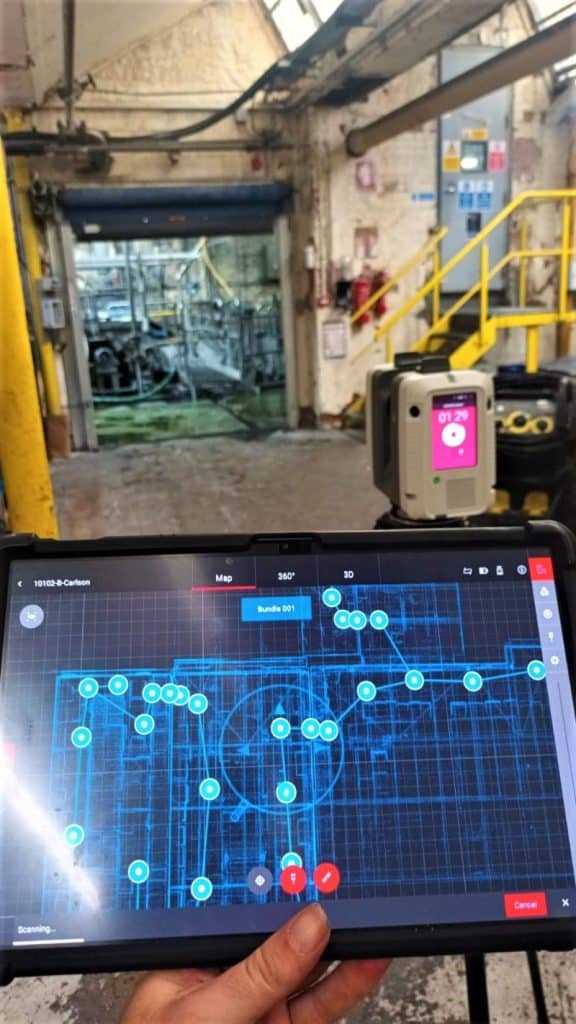
Factory Scanning & Utility Mapping, Barnoldswick
3D Laser Scanning & Utility Mapping
An interesting industrial commission in Barnoldswick — scanning the internals of a factory building using the Leica RTC scanner, ahead of a utility mapping programme scheduled for a few weeks later. Factory interiors present their own specific scanning challenges: dense machinery, complex structural steelwork, restricted sightlines, and plenty to negotiate through. The RTC handled it all with characteristic reliability.
The phased approach — scanning the building fabric first, followed by utility mapping of the underground services — gives the client a complete picture of what exists both above and below ground before any works begin. In a working industrial building with years of accumulated infrastructure, that comprehensive understanding is invaluable for any refurbishment, expansion, or redevelopment programme.
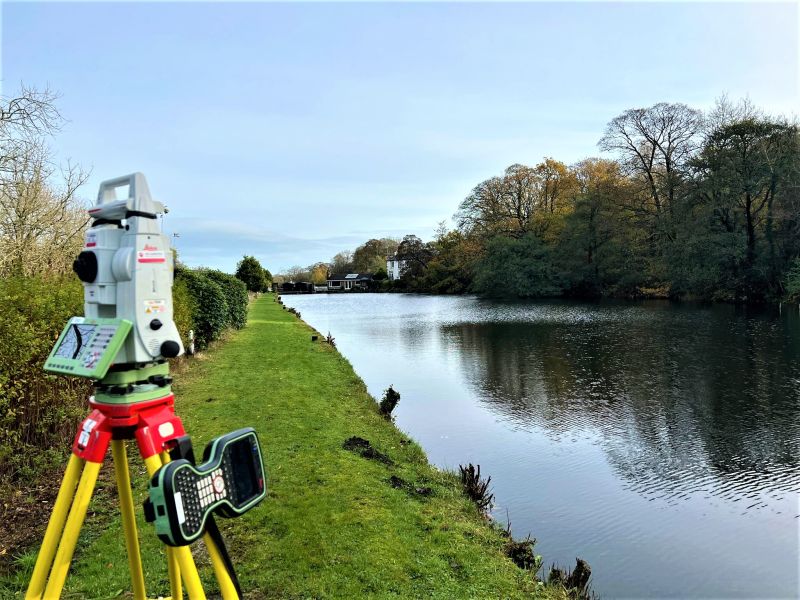
Topographic Survey, Nelson — Fishing Pond
Topographic Survey
Completely hooked on this one — a topographic survey of a lovely fishing pond in Nelson on a brisk autumn morning. Watercourse and water body surveys of this kind capture precise level data, bank profiles, and surrounding features that support management, planning, and environmental assessment work. The team may or may not have been tempted to cast a line afterwards.
Pendle's Development Landscape
Pendle's Development Landscape
Pendle is a borough in the early stages of a significant planning and development chapter. The Pendle Local Plan Fourth Edition 2021–2040 was formally adopted at Full Council on 18 December 2025 — the culmination of several years of preparation and the most up-to-date planning document in the borough’s history. The plan provides a clear framework for housing, employment, and infrastructure development across Nelson, Colne, Barnoldswick, Earby, and the wider borough through to 2040. The borough’s manufacturing and industrial heritage continues to evolve, with Barnoldswick in particular maintaining a strong advanced manufacturing identity — home to Rolls-Royce’s jet engine test facility and a cluster of precision engineering businesses. The renewable energy sector is also active across East Lancashire’s moorland, with wind energy installations and associated infrastructure generating survey demand across the upland fringe. For the wider East Lancashire area, Hyndburn Borough Council’s planning framework guides development in Accrington, Great Harwood, and surrounding communities.
Why Choose Site Surveying Services in Pendle & East Lancashire?
Why Choose Site Surveying Services in Pendle & East Lancashire?
Right on the doorstep
based in Clitheroe, on the Pendle borough boundary, we are closer to this area than any out-of-county firm and can mobilise immediately
Monitoring and energy sector experience
from wind farm monitoring campaigns to return visits for setting out works, we support energy and infrastructure projects through their full lifecycle
Industrial scanning specialists
the Barnoldswick factory commission demonstrates our capability in complex, cluttered industrial interiors where accuracy and perseverance matter
Watercourse and environmental surveys
topographic surveys of ponds, watercourses, and environmental features across East Lancashire's river and moorland landscapes
Phased project support
returning to sites over months and years as projects progress, building the kind of longstanding relationships East Lancashire clients value
Competitive pricing
top quality services at cost-effective rates, delivered efficiently across the local area
Frequently Asked Questions
Frequently Asked Questions
What is a monitoring campaign and why is it used on construction and energy sites?
A monitoring campaign involves periodically measuring and recording changes in the physical features of a site over time — tracking ground movement, subsidence, structural shifts, or changes caused by construction, excavation, or natural processes. On wind farm, infrastructure, and mining sites, monitoring provides the data needed to manage ground risk, demonstrate compliance with planning conditions, and identify any movement requiring action before it affects the programme or safety of the works.
Do you carry out laser scanning of factory and industrial buildings in Barnoldswick and East Lancashire?
Yes. Our Barnoldswick factory commission demonstrates our capability in complex industrial environments. We use the Leica RTC scanner to capture comprehensive interior data in buildings with dense machinery, structural steelwork, and restricted sightlines — delivering the accurate building record that refurbishment, expansion, and planning teams need.
Can you combine scanning and utility mapping on the same industrial site?
Yes — and we’d recommend it wherever possible. Scanning the building fabric and mapping underground utilities in a coordinated programme gives the client a complete above and below-ground picture of the site before any works begin. Phasing the two surveys (scanning first, utility mapping following) allows the underground services to be planned around the building geometry established by the scan.
Do you carry out topographic surveys of watercourses and water features in East Lancashire?
Yes. Topographic surveys of fishing ponds, rivers, and watercourses are a regular part of our work across the Pendle and Ribble Valley area. We capture precise level data, bank profiles, and surrounding site features to support management, planning, and environmental assessment purposes.