


 Leeds
Leeds Doncaster
 Sheffield
 Bradford
 Hull
Hull Halifax
 Sunderland
 Newcastle
 Middlesborough
 Yorkshire Moors
 Teesside
 Cumbria
 Harrogate
 York
York Yorkshire Dales
 Northumberland
 Goole
Goole Carlisle
 Keswick
 Kendal
 Barrow-in-Furness
 Lancaster
 Blackpool
 Morecambe
 Southport
 Liverpool
 Wigan
Wigan Manchester
 Blackburn
 Burnley
 Forest of Bowland
 Oldham
 Chester
 Stockport
 Peak District
 Skipton
 Crewe
Crewe Rotherham
 Stoke
Stoke Driffield
Land and engineering surveyors based in Lancashire
Survey Equipment Hire & Sales
Survey Equipment Hire Lancashire and the North West
Survey Equipment Hire Lancashire and the North West
The right survey equipment, calibrated and ready to use, available when your programme needs it. Site Surveying Services maintains a modern fleet of professional survey instrumentation available for short and long-term hire across Lancashire, the North West and nationally. Every piece of equipment in our hire fleet is the same instrumentation our directly employed survey team uses on live programmes every day. We know it works because we depend on it ourselves. We do not hire out equipment we would not trust on our own projects — and that distinction matters when the setting-out has to be right and the data has to be accurate.
All hire equipment is regularly serviced and calibrated by the manufacturer and checked in-house at the intervals the manufacturer requires. Every hire includes a calibration certificate confirming the equipment is performing within specification. If something is not right when you collect or receive it, call us and we will resolve it — the same day.
Equipment Available for Hire
Equipment Available for Hire
GNSS Base Stations
Professional dual-frequency GNSS base stations for establishing a local RTK correction source on site. Suitable for setting-out, topographic survey and machine control calibration where a network RTK signal is unavailable or where the programme requires an independent base station for additional reliability.
Applications: rural and remote sites without network RTK coverage, large sites where network signal is unreliable, machine control calibration, control network verification. What to check: confirm your rover is compatible with the base station’s correction format (RTCM, CMR or manufacturer-specific). We advise on compatibility at the time of hire.
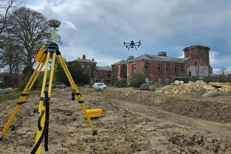
GNSS Rovers — VRS and RTK
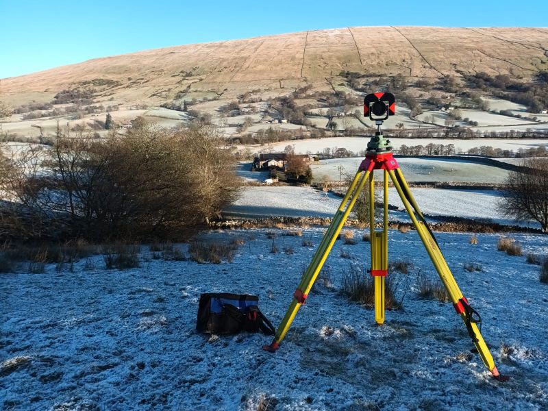
Robotic Total Stations
3D Laser Scanners
High-precision terrestrial laser scanners for point cloud capture in confined spaces, heritage buildings, industrial facilities and any environment requiring dense three-dimensional data capture. Produce millions of measured points per scan position, registered together to produce a complete georeferenced point cloud.
Applications: measured building surveys, heritage recording, as-built verification, confined space survey, structural assessment. What to check: confirm you have the processing software required to handle the raw scan data and produce your deliverable format. We can advise on processing and can offer processing support if required.
Digital Levels
Dual Grade Lasers
Contact Us to Hire.
Contact Us to Hire.
Contact
Choosing the Right Equipment for Your Project.
Choosing the Right Equipment for Your Project.
Not every application requires the same instrument — and specifying the wrong equipment wastes hire cost and can affect data quality. Here is a guide to matching equipment to common applications.
Topographic survey on an open site with good sky visibility
GNSS rover (VRS or RTK) is the most efficient method. Check network RTK coverage for your location before hiring.
Setting-out inside a building or under an obstruction
robotic total station. GPS does not work reliably indoors or under heavy canopy and bridge decks. Total station is the correct instrument.
Control traverse — establishing secondary control from primary
robotic total station. GNSS is suitable for primary control but total station traversing is typically more appropriate for dense secondary networks on constrained sites.
Measured building survey or as-built in a complex space
laser scanner. The density of data captured by a scanner in a single setup cannot be achieved with a total station in a comparable time.
Monitoring — precise vertical movement detection
digital level. Sub-millimetre vertical accuracy, independent of satellite signal, essential for settlement monitoring adjacent to construction.
Slab levels and formation control for groundworks
dual grade laser. Simple, fast, does not require a skilled surveyor to operate once set up.
UAV ground control point measurement
GNSS rover (VRS or RTK). GPS measurement of target positions to tie aerial data to OS National Grid.
If you are not sure which equipment is right for your application, call us. We use all of this equipment ourselves on live programmes and we will tell you what you need — and what you do not.
Why Hire from Site Surveying Services.
Why Hire from Site Surveying Services.
The hire fleet is the same equipment our survey team uses. If we would not trust it on a BAE Systems MOD facility or a live highways programme, it is not in the hire fleet.
Every instrument is manufacturer-serviced and calibrated at the required intervals. Every hire includes a calibration certificate. You know the equipment is performing within specification before you start.
We know how these instruments work in the field, not just how they are described in a brochure. If you have a question about setup, compatibility, network RTK coverage or the right instrument for your application, call us.
We always aim to beat a comparable quote from a specialist hire company. Call us with your requirement and we will give you a direct rate.
Head office in Clitheroe, offices in Matlock, Newcastle and Bristol. Equipment can be collected from or delivered to any of our offices. For urgent requirements, call us directly.
Our Services
Topographical Surveys
OS-controlled accurate, efficient and cost effective surveys for highways, civils and development. Cad and BIM-ready output.
PAS 128 utility mapping
Providing the location of underground services in 2D or 3D through qualified utility mapping surveys, using advanced GPR and Electromagnetic Location.
Measured building survey
Delivering accurate as-built information that supports design, refurbishment, planning and construction with the latest technology. Producing reliable drawings and digital models.
Laser Scanning
3D laser scanners capture millions of points per second, creating a point cloud which enables the finer details and the physical site to be viewed remotely.
Mobile mapping
For highway engineers, infrastructure managers, local authorities and contractors working on live road schemes, mobile mapping is now the standard for corridor surveys.
3D Machine control
With decades of supporting major earthworks contractors and large-scale infrastructure schemes, we provide reliable machine control across Lancashire and the wider UK.
Setting out engineers
With strong, long-standing relationships across the civil engineering and construction sector, we supply skilled professionals who keep your projects accurate, efficient and on programme.
bathymetric surveys & river surveys
Using modern technology, we capture detailed underwater and river channel information safely and efficiently – delivering reliable data you can trust.
Stockpile surveys & volumetric analysis
Whether a one-off stockpile measurement or regular monitoring, we deliver reliable, repeatable data tailored to your project using advanced technology.
Control Network Installation
Delivering robust and precise site control systems to support every stage of construction in developments, infrastructure schemes or major earthworks.
aerial & drone surveys
CAA-approved drone operations for aerial mapping, photogrammetry and volumetric analysis, providing a comprehensive view of terrain, structures and landscapes.
3D BIM Modelling
Whether you require an as-built Revit model, federated coordination model or detailed digital twin, our team delivers high quality, design-ready outputs.
survey equipment hire
We offer a vast range of surveying and engineering equipment for hire and will always try to beat a comparable quote. Discover the fleet.
monitoring
Providing reliable monitoring surveys across the UK, delivering precise data that supports risk management, compliance and informed decision making throughout a project lifecycle.
Virtual Tour 3D
An immersive experience which instantly transports your clients to your business, guiding them through your space and creating a seamless experience.
Impermeable area surveys
We deliver georeferenced impermeable area data that drainage engineers and planning consultants can work from directly.
CCTV & Drainage surveys
Acoustic & Noise Assessments
We deliver acoustic and noise assessments, supporting planning applications, discharge of conditions and Environmental Impact Assessments.
Why choose site surveying services
On site. On spec. On time.
fast turnaround
Get a quick quote and a survey team prepared for instruction. When the programme window opens, we're ready.
Industry Accredited
Built on recognised industry standards. Constructionline Gold accredited, CAA Approved, CDM 2015 compliant, and surveys delivered to PAS 128
Nationwide
Coverage across the UK with local knowledge you can rely on. Headquartered in Clitheroe, we know the sites, the contractors and the programmes — backed by the capability to deliver anywhere.
Programme-Critical
Data that works in your environment from day one. BIM to your EIR. CAD to your spec. No reprocessing. No delays to the design team.
Frequently Asked Questions
Frequently Asked Questions
What survey equipment do you have available for hire?
We currently offer GNSS base stations, GNSS rovers (VRS and RTK), robotic total stations, 3D laser scanners, digital levels and dual grade lasers. All equipment is from leading manufacturers including Leica and CHCNAV — the same instrumentation our directly employed survey team uses on live programmes. Call us to confirm current availability for your hire dates.
How do I know which equipment to hire for my project?
The right instrument depends on your application — topographic survey, setting-out, monitoring, building survey — and your site conditions. GNSS rovers are efficient for open sites with good satellite visibility. Robotic total stations are necessary inside buildings or under obstructions. Laser scanners are appropriate for dense point cloud capture. Digital levels for precise height measurement. Dual grade lasers for slab and formation level control. If you are not sure, call us and describe what you need to achieve — we will tell you the right instrument.
Is the equipment calibrated?
Yes. All hire equipment is manufacturer-serviced and calibrated at the intervals the manufacturer requires. Every hire includes a calibration certificate confirming the equipment is performing within specification at the time of hire. We also check all equipment in-house before it leaves us and after it returns — any equipment that does not meet our internal check standards is withdrawn from the hire fleet.
Do you offer delivery and collection?
Yes. Equipment can be collected from or delivered to our offices in Clitheroe, Matlock, Newcastle or Bristol. For delivery to site or other locations, contact us to confirm availability and any delivery charge. For urgent requirements, call us directly — we will do what we can to get equipment to you when you need it.
What hire periods are available?
We offer daily, weekly and monthly hire periods. For longer-term requirements — a programme of several months where continuous equipment availability is needed — contact us to discuss a programme hire arrangement. We are flexible on hire periods and will always try to accommodate the programme timescale.
Can I hire equipment without an operator?
Yes. All equipment is available for dry hire — equipment only, without an operator. This is appropriate where you have your own qualified survey team. If you need both the equipment and a qualified engineer to operate it, our setting-out engineers are fully self-equipped and this is typically more cost-effective than separate hire and labour.
Do you sell used survey equipment?
Yes, periodically. As we refresh our fleet with newer equipment, ex-fleet instruments become available for sale — maintained and calibrated to the same standard as our hire fleet. Contact us directly to enquire about specific instruments or to ask about upcoming availability.
What happens if the equipment develops a fault on site?
Call us immediately. We will advise on whether the issue can be resolved remotely — most common problems are setup or configuration issues that can be resolved quickly over the phone — or whether the equipment needs to be replaced. Where replacement is required due to equipment fault rather than operator error, we will arrange replacement as quickly as possible.
Do you cover the whole of the UK?
Equipment can be collected from or delivered to any of our four offices — Clitheroe, Matlock, Newcastle and Bristol. For sites not near any of our offices, contact us to discuss delivery options. We cover the full UK for hire and will find the most practical solution for your location.