


 Leeds
Leeds Doncaster
 Sheffield
 Bradford
 Hull
Hull Halifax
 Sunderland
 Newcastle
 Middlesborough
 Yorkshire Moors
 Teesside
 Cumbria
 Harrogate
 York
York Yorkshire Dales
 Northumberland
 Goole
Goole Carlisle
 Keswick
 Kendal
 Barrow-in-Furness
 Lancaster
 Blackpool
 Morecambe
 Southport
 Liverpool
 Wigan
Wigan Manchester
 Blackburn
 Burnley
 Forest of Bowland
 Oldham
 Chester
 Stockport
 Peak District
 Skipton
 Crewe
Crewe Rotherham
 Stoke
Stoke Driffield
Surveying Services North West
Site Surveying Services in Warrington, Cheshire
Warrington is one of the North West’s most strategically important towns — a major economic hub sitting at the heart of the motorway network between Manchester and Liverpool, with one of the highest concentrations of logistics, commercial, and distribution activity of any town in England. Fast-growing, well-connected, and with an ambitious regeneration agenda focused on its town centre, waterfront, and surrounding employment land, Warrington generates consistent and varied demand for professional surveying services across its commercial, residential, and infrastructure sectors. Site Surveying Services delivers professional surveying across Warrington, with direct experience of measured building survey commissions in the town’s hospitality sector — working to tight deadlines and delivering accurate, complete floor plans and elevations that give architects and developers the precise spatial data they need to move their projects forward efficiently.
Based in Clitheroe and accessible via the M6 and M62, our team can mobilise quickly to Warrington for any survey requirement, combining the responsiveness of a local firm with the technology and track record of a national specialist.
Our Surveying Services in Warrington
We offer a comprehensive range of professional surveying services to clients across Warrington:
Topographic Surveys Warrington
detailed land and site surveys for planning, drainage, and development across the borough
Measured Building Surveys Warrington
accurate internal floor plans, elevations, and sections for hotels, commercial buildings, retail properties, and residential conversions
3D Laser Scanning Warrington
high-density point cloud surveys for complex buildings, refurbishment projects, and BIM production
Utility Surveys Warrington
underground service detection and mapping using GPR, CAT & Genny
Sectors We Serve in Warrington
Our Warrington project capability covers the town’s distinctive mix of commercial, hospitality, logistics, and residential activity:
Hospitality & Hotels
measured building surveys for hotel refurbishment, conversion, and redevelopment projects
Commercial & Logistics
surveys for Warrington's extensive commercial and logistics estate, one of the largest in the North West
Retail & Town Centre
surveys for retail properties and town centre regeneration schemes
Infrastructure & Transport
surveys for road, rail, and public realm projects across Warrington's strategic transport network
Residential Development
topographic and utility surveys for housing schemes across the borough
Industrial & Employment
surveys for industrial estates and employment land across the borough
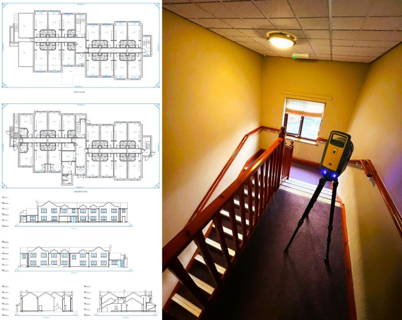
Case Study: Premier Inn, Warrington — Measured Building Survey
Case Studies & Project Highlights
A measured building survey commission at a Premier Inn in Warrington — delivered under a tight deadline with the site work completed and accurate internal floor plans and elevations produced, checked, and issued to the client within the same week. Hospitality surveys of this kind are a familiar commission for our team. Producing accurate floor plans and elevations of an existing hotel building — capturing every room, corridor, stairwell, and external elevation with precision — requires methodical planning and efficient execution, particularly when programme timescales are tight. Our team deployed scanning technology to capture comprehensive internal and external data across the building, producing the detailed floor plan and elevation drawings the client needed to progress their project.
The speed of delivery — from site completion to checked, issued drawings within days — reflects our commitment to programme responsiveness. When deadlines are tight and architects or developers need data quickly to keep their project moving, we deliver. This commission forms part of a broader track record of hotel and hospitality sector survey work across the North West, including measured building surveys at Premier Inns in Kendal and Blackpool as part of Whitbread’s national programme to convert restaurant sites into new hotel rooms.
Client details
Premier Inn
service provided
Measured Building Survey (Internal Floor Plans & Elevations)
Warrington's Development Landscape
Warrington's Development Landscape
Warrington is one of the North West’s most active development towns — a town of significant economic scale and ambition, with a population approaching 230,000 and a growth trajectory that has made it one of England’s fastest-expanding urban centres over recent decades. Its strategic location at the junction of the M6, M62, and M56 motorways makes it a natural hub for logistics, distribution, and commercial investment, while its town centre regeneration programme — including the Time Square development and ongoing waterfront investment — is reshaping Warrington’s commercial and leisure offer. The Warrington Local Plan 2021/22–2038/39 was adopted on 4 December 2023 — one of the most recently adopted Local Plans in the North West — providing a fresh, up-to-date planning framework for the borough through to 2039.
Why Choose Site Surveying Services in Warrington?
Why Choose Site Surveying Services in Warrington?
Fast turnaround
our Warrington Premier Inn commission demonstrates our ability to complete site work and issue checked, accurate drawings within days when deadlines demand it
Hospitality sector expertise
measured building surveys for hotels across the North West, from Warrington to Kendal and Blackpool, supporting major national hospitality conversion programmes
Full service range
measured building surveys, laser scanning, topographic surveys, utility mapping, and setting out all in-house
M6/M62 connected
Warrington is approximately 45 minutes from our Clitheroe base; fast mobilisation across the borough and wider Cheshire area
Frequently Asked Questions
Frequently Asked Questions
Do you carry out measured building surveys for hotels and hospitality properties in Warrington?
Yes — our Premier Inn commission in Warrington is a strong example. We produce detailed internal floor plans and elevations for hotel buildings, working efficiently to tight deadlines and delivering checked, accurate drawings promptly. We have experience across the hospitality sector throughout the North West.
How quickly can you produce and issue measured building survey drawings in Warrington?
Very quickly when required. Our Warrington commission saw site work completed and accurate floor plans and elevations produced, checked, and issued to the client within the same week. Turnaround time depends on building size and complexity, but responsive delivery is something we consistently deliver on.
Do you carry out laser scanning for measured building surveys in Warrington?
Yes. Laser scanning is our preferred methodology for measured building surveys, capturing comprehensive interior and exterior data efficiently and accurately. The scan data is then used to produce floor plans, elevations, and sections to the required specification.
Can you carry out topographic surveys for planning applications in Warrington?
Yes. We provide topographic surveys across Warrington and the wider borough to support planning applications, drainage assessments, and development appraisals, delivered in CAD or other agreed formats.
Do you carry out utility surveys for commercial and development sites in Warrington?
Yes. Utility mapping is an essential first step for any development involving ground works or excavation. We carry out GPR and electromagnetic utility surveys across Warrington’s commercial, industrial, and residential development sites.