


 Leeds
Leeds Doncaster
 Sheffield
 Bradford
 Hull
Hull Halifax
 Sunderland
 Newcastle
 Middlesborough
 Yorkshire Moors
 Teesside
 Cumbria
 Harrogate
 York
York Yorkshire Dales
 Northumberland
 Goole
Goole Carlisle
 Keswick
 Kendal
 Barrow-in-Furness
 Lancaster
 Blackpool
 Morecambe
 Southport
 Liverpool
 Wigan
Wigan Manchester
 Blackburn
 Burnley
 Forest of Bowland
 Oldham
 Chester
 Stockport
 Peak District
 Skipton
 Crewe
Crewe Rotherham
 Stoke
Stoke Driffield
Precision data for sustainable decisions. Survey methodology that matches the environment.
Architecture & Project Management Surveying
Environmental and energy projects in the North West present survey challenges that standard construction methodology cannot always address. Wetland sites where ground-based access is restricted or harmful to the habitat. River corridors where the data needed lies beneath the water surface. Wind farm and solar development sites across challenging Pennine, Lakeland and moorland terrain. Flood risk assessments where every level and drainage feature matters to the modelling. Water infrastructure upgrade schemes operating under AMP8 investment where the survey data directly underpins programme-critical design decisions.
Site Surveying Services has been delivering survey across this sector since 1997 — using UAV LiDAR, unmanned surface vessels, remote sensing and GPS-controlled ground survey to capture data safely and accurately in environments where traditional methods are impractical, too slow or potentially damaging to what is being surveyed. We are Lancashire-based, nationally capable, and our equipment is specifically chosen for the environments this sector demands.
Design Surveying & Planning for Architecture
Design Surveying & Planning for Architecture
At Site Surveying Services Ltd, we provide specialist architectural and property surveying services that support every stage of architecture and planning, from early feasibility through to construction and project delivery. Our accurate, data-driven surveys form the foundation for confident design decisions, risk reduction, and successful building projects.
We work closely with architects, project managers, national house builders, small local developers and landowners, delivering reliable surveying solutions that align with design intent, planning requirements and project timelines.
The Importance of Surveying for Architects & Project Managers
Accurate surveying is fundamental to architectural design and effective project management. Without precise site information, architectural concepts risk delays, redesigns, and increased costs during construction. High-quality architectural site surveys ensure that design decisions are based on real-world conditions rather than assumptions. Our measured building and architectural surveys allow architects and developers to progress confidently through planning, technical design, and construction phases. By providing accurate survey data from the outset, we help reduce risk, improve coordination between consultants, and support efficient project delivery.
Designs based on real-world conditions
clash risks are reduced during construction
project costs and timelines remain controlled
planning submissions are accurate & robust
We understand the key requirements for architects and property developers, including the need for accurate data, clear deliverables, and reliable turnaround times. Our architectural site survey services are designed to support planning submissions, design development, and construction coordination with minimal risk and maximum clarity.
By working collaboratively with design teams, we ensure that our surveys meet the specific needs of each building project, regardless of size or complexity. Architectural surveying applies across a wide range of sectors, including residential, commercial, mixed-use, education, industrial, and heritage developments. Each sector presents unique challenges, from tight urban sites to complex existing structures, and our surveying approach is adapted accordingly. Our experience across these sectors enables us to provide practical, accurate survey solutions that support architecture and planning requirements nationwide.
Our Services
Topographical Surveys
OS-controlled accurate, efficient and cost effective surveys for highways, civils and development. Cad and BIM-ready output.
PAS 128 utility mapping
Providing the location of underground services in 2D or 3D through qualified utility mapping surveys, using advanced GPR and Electromagnetic Location.
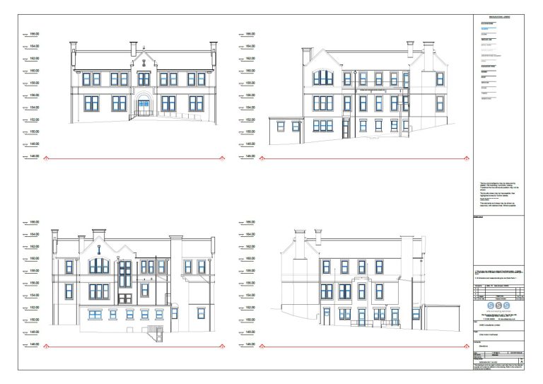
Measured building survey
Delivering accurate as-built information that supports design, refurbishment, planning and construction with the latest technology. Producing reliable drawings and digital models.
Laser Scanning
3D laser scanners capture millions of points per second, creating a point cloud which enables the finer details and the physical site to be viewed remotely.
Mobile mapping
For highway engineers, infrastructure managers, local authorities and contractors working on live road schemes, mobile mapping is now the standard for corridor surveys.
3D Machine control
With decades of supporting major earthworks contractors and large-scale infrastructure schemes, we provide reliable machine control across Lancashire and the wider UK.
Setting out engineers
With strong, long-standing relationships across the civil engineering and construction sector, we supply skilled professionals who keep your projects accurate, efficient and on programme.
bathymetric surveys & river surveys
Using modern technology, we capture detailed underwater and river channel information safely and efficiently – delivering reliable data you can trust.
Stockpile surveys & volumetric analysis
Whether a one-off stockpile measurement or regular monitoring, we deliver reliable, repeatable data tailored to your project using advanced technology.
Control Network Installation
Delivering robust and precise site control systems to support every stage of construction in developments, infrastructure schemes or major earthworks.
aerial & drone surveys
CAA-approved drone operations for aerial mapping, photogrammetry and volumetric analysis, providing a comprehensive view of terrain, structures and landscapes.
3D BIM Modelling
Whether you require an as-built Revit model, federated coordination model or detailed digital twin, our team delivers high quality, design-ready outputs.
survey equipment hire
We offer a vast range of surveying and engineering equipment for hire and will always try to beat a comparable quote. Discover the fleet.
monitoring
Providing reliable monitoring surveys across the UK, delivering precise data that supports risk management, compliance and informed decision making throughout a project lifecycle.
Virtual Tour 3D
An immersive experience which instantly transports your clients to your business, guiding them through your space and creating a seamless experience.
Impermeable area surveys
We deliver georeferenced impermeable area data that drainage engineers and planning consultants can work from directly.
CCTV & Drainage surveys
Acoustic & Noise Assessments
We deliver acoustic and noise assessments, supporting planning applications, discharge of conditions and Environmental Impact Assessments.
Why choose site surveying services
On site. On spec. On time.
The survey scope built around your EIR
We review the Employer's Information Requirements at instruction — confirming the LOD, the Revit version, the coordinate system and the naming convention before any scan is taken.
CPD sessions for your practice. Free.
Scan to BIM methodology, point cloud workflows, Revit model delivery and survey data in the design process — we have delivered CPD to architectural practices across the North West. Contact us to arrange a session.
RIBA Stage 1 through to Stage 6. One team.
Indicative survey at Stage 1. Full measured building survey at Stage 2. BIM coordination model at Stage 3. As-built at Stage 6. The same organisation throughout the RIBA programme — with the spatial knowledge of the building.
The model checked against the scan. Every time.
Before any Revit model leaves our office, it is verified against the point cloud by our in-house BIM team. The check that confirms the model represents the building — not the building we assumed was there.
Frequently Asked Questions
Frequently Asked Questions
What survey do I need at each RIBA stage?
RIBA Stage 1 — an indicative topographic survey to inform the project brief and a measured building survey of existing structures at a scale appropriate for briefing. RIBA Stage 2 — full topographic survey to OS National Grid and a complete measured building survey to the accuracy required for concept design. RIBA Stage 3 — BIM-ready survey data at the LOD specified in the EIR for multidisciplinary coordination. Where BIM was not specified at Stage 2, Stage 3 is the last practical point at which a BIM-ready dataset can be introduced before coordination is too advanced. RIBA Stage 4 — check surveys and supplementary data capture to verify specific features at higher accuracy for technical detail. RIBA Stage 5 — as-built verification at programme stages. RIBA Stage 6 — final as-built measured building survey and Virtual Tour 3D for client handover. Commissioning survey at Stage 1 rather than Stage 2 is consistently more efficient — the brief is better informed, the design starts from verified data and the risk of late-stage surprises is significantly reduced.
What is the difference between a measured building survey and a floor plan?
A floor plan is a 2D drawing showing the layout of a building at one level. A measured building survey is a comprehensive package — floor plans at every level, external elevations, building sections, ceiling heights, structural positions, roof layout and any other building data the design brief requires. A floor plan can be part of the output of a measured building survey. A measured building survey is the full, verified dataset from which usable floor plans and all other design documents are produced — based on laser scan data rather than tape measurement, and checked against the point cloud before delivery.
What should an architect specify in a survey brief?
The more detail you provide at instruction, the better the survey will be scoped. Useful information includes: the site address and access arrangements, any existing drawings (even inaccurate — they help us understand the building), the RIBA stage the survey needs to serve, the deliverable format you require, the Revit version if BIM is required, any specific features or areas needing particular attention, your programme timescale, and whether a BIM model is required and to what LOD. If you are not sure what to specify, tell us what the survey data needs to support and we will advise on the scope. Getting the scope right at the start avoids additional visits and abortive work.
Do you offer CPD sessions for architectural practices?
Yes. We offer free CPD sessions for architectural and design practices covering scan to BIM methodology, point cloud workflows, Revit model delivery and the practical integration of survey data into the design process. Our first session was delivered to Cassidy Ashton in Preston. If your practice would benefit from a session on any aspect of survey data in architectural design workflows, contact us to arrange it.
Can you deliver survey data directly in Revit?
Yes. We produce Revit models in-house from laser scan data — structured to your EIR, at the LOD your project specifies, in the Revit version your practice uses. All modelling is completed by our directly employed team. The model is checked against the point cloud before delivery. You receive a model that accurately represents the building as surveyed — not a model produced by a third party from data they were not involved in collecting.
What is a point cloud and how do I use it in my design workflow?
A point cloud is the raw output of a laser scan — millions of measured data points, each with an X, Y and Z coordinate, collectively representing the three-dimensional geometry of the scanned environment. In a design workflow, point clouds can be imported into Revit, AutoCAD, Rhino, SketchUp and most major design platforms, allowing the design team to view and measure the existing building in 3D without returning to site. We deliver point cloud data in RCP, RCS, E57 or LAS format — confirm your preference at the time of instruction.
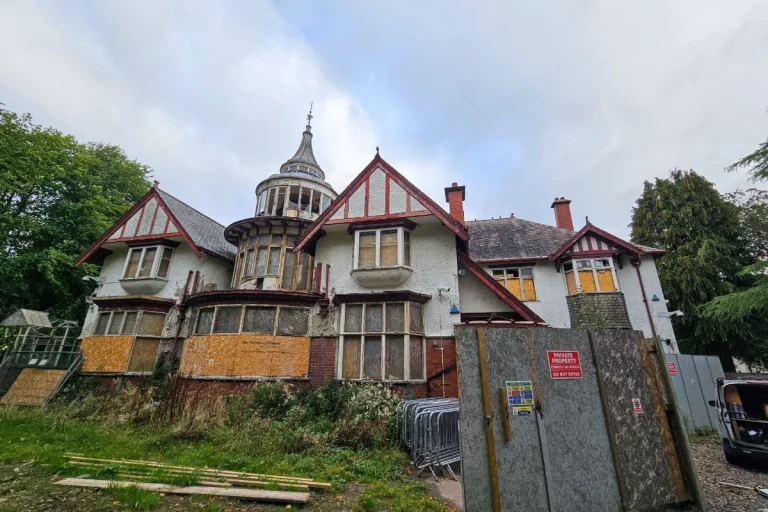
How do you survey listed and heritage buildings for architectural design?
Heritage buildings are some of the most important measured building survey applications — the scan captures the full complexity of irregular geometry, historic detailing and building fabric variation that tape survey cannot reliably record. We survey listed buildings across Lancashire and the North West including Victorian commercial buildings, listed market halls, churches, heritage industrial buildings and complex conservation environments. Our methodology for heritage survey is always agreed with the client before the site visit — including the level of detail required, access requirements and whether photogrammetric record is needed alongside the scan.
What LOD should I specify for my BIM survey?
LOD 200 for concept design and planning where approximate geometry is sufficient. LOD 300 for technical design coordination — this is the standard for refurbishment and extension projects where structural and MEP disciplines need to coordinate from the model. LOD 400 for complex heritage projects, high-value fit-out and any project where the construction team will work directly from the model. LOD 500 for the as-built record at handover for facilities management. If you are not certain which LOD is appropriate for your project and how the model will be used downstream, ask us — we advise on LOD specification as part of every BIM survey commission.