

 Leeds
Leeds Doncaster
 Sheffield
 Bradford
 Hull
Hull Halifax
 Sunderland
 Newcastle
 Middlesborough
 Yorkshire Moors
 Teesside
 Cumbria
 Harrogate
 York
York Yorkshire Dales
 Northumberland
 Goole
Goole Carlisle
 Keswick
 Kendal
 Barrow-in-Furness
 Lancaster
 Blackpool
 Morecambe
 Southport
 Liverpool
 Wigan
Wigan Manchester
 Blackburn
 Burnley
 Forest of Bowland
 Oldham
 Chester
 Stockport
 Peak District
 Skipton
 Crewe
Crewe Rotherham
 Stoke
Stoke Driffield


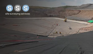
Planners and consultants should use UAV (drone) surveys when accurate, up-to-date aerial data is required for planning applications, feasibility studies, land assessments or infrastructure design. UAV surveys are particularly valuable for large, complex or hard-to-access sites where traditional survey methods may be slower, riskier or less cost-effective.
Drone surveys are commonly used for:
Planning applications and site feasibility studies
Topographical surveys for development proposals
Flood risk and environmental assessments
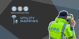
Infrastructure and corridor mapping
Progress monitoring and site verification
Volume calculations and earthworks measurement
UAV surveys provide high-resolution imagery, orthomosaics, digital terrain models (DTMs) and 3D site data, allowing planners and consultants to make informed decisions with confidence.
By combining aerial capture with ground control and GNSS positioning, survey-grade drone data can be integrated directly into CAD, BIM and GIS workflows.