

Land and engineering surveyors based in Lancashire
Bathymetric Surveys & River Surveys
Need the full package?
Bathymetric Surveys and river surveys Lancashire and the North West
Professional River & Bathymetric Surveys Across the UK
Professional River & Bathymetric Surveys Across the UK
Rivers, watercourses, reservoirs, canals and coastal environments present survey challenges that standard land techniques cannot address. The data needed to support flood risk assessments, bridge structural inspections, dredging programmes, environmental monitoring and hydraulic modelling does not exist above the waterline. It exists at the riverbed — in the channel profiles, the bed levels, the sediment data and the underwater features that determine how a watercourse behaves under flood conditions.
Site Surveying Services delivers professional bathymetric and river surveys across Lancashire, the North West and nationally — producing EA-compliant cross sections, longitudinal profiles and digital channel models that flood risk engineers, hydraulic modellers, environmental consultants and infrastructure engineers can work from directly. Based in Clitheroe, Lancashire, our team has surveyed watercourses across the North West from urban rivers in Greater Manchester to remote watercourses in the Ribble Valley, the Forest of Bowland and across the Pennine fringes. 9The data that supports confident decisions near water starts with an accurate survey. That is what we deliver.
What is a Bathymetric Survey?
A bathymetric survey measures the depth and profile of water bodies such as rivers, streams, canals and reservoirs. It maps underwater terrain in the same way a topographical survey maps land. Bathymetric surveys capture:
The resulting survey data forms the foundation for hydraulic modelling and flood risk analysis.
What is a River Survey?
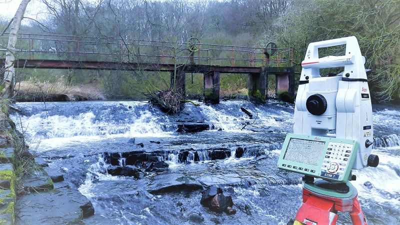
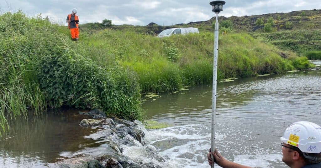
A river survey is the process of measuring and recording the physical characteristics of a watercourse — the channel geometry, the bed levels, the bank profiles, the hydraulic structures and the surrounding flood plain — to produce a dataset that engineers, planners and environmental managers can base decisions on. Rivers, watercourses and water bodies present a fundamental survey challenge: the data that matters most is beneath the water surface, in an environment that standard GPS and total station survey cannot reach. A river survey combines above-water topographic methods with specialist below-water bathymetric techniques to capture the complete picture — from the flood plain, across the bank, through the water column and down to the channel bed.
Site Surveying Services delivers river surveys across Lancashire, the North West and nationally — using GPS ground survey for the topographic elements, the CHC Navigation Apache 4 unmanned surface vessel for the bathymetric elements, and UAV LiDAR where the survey area extends across wide flood plains or ecologically sensitive terrain that ground survey cannot efficiently cover.
Every river survey we produce is OS-controlled, referenced to Ordnance Datum Newlyn, and delivered in the format your hydraulic engineer, flood risk consultant or environmental manager requires — without reprocessing.
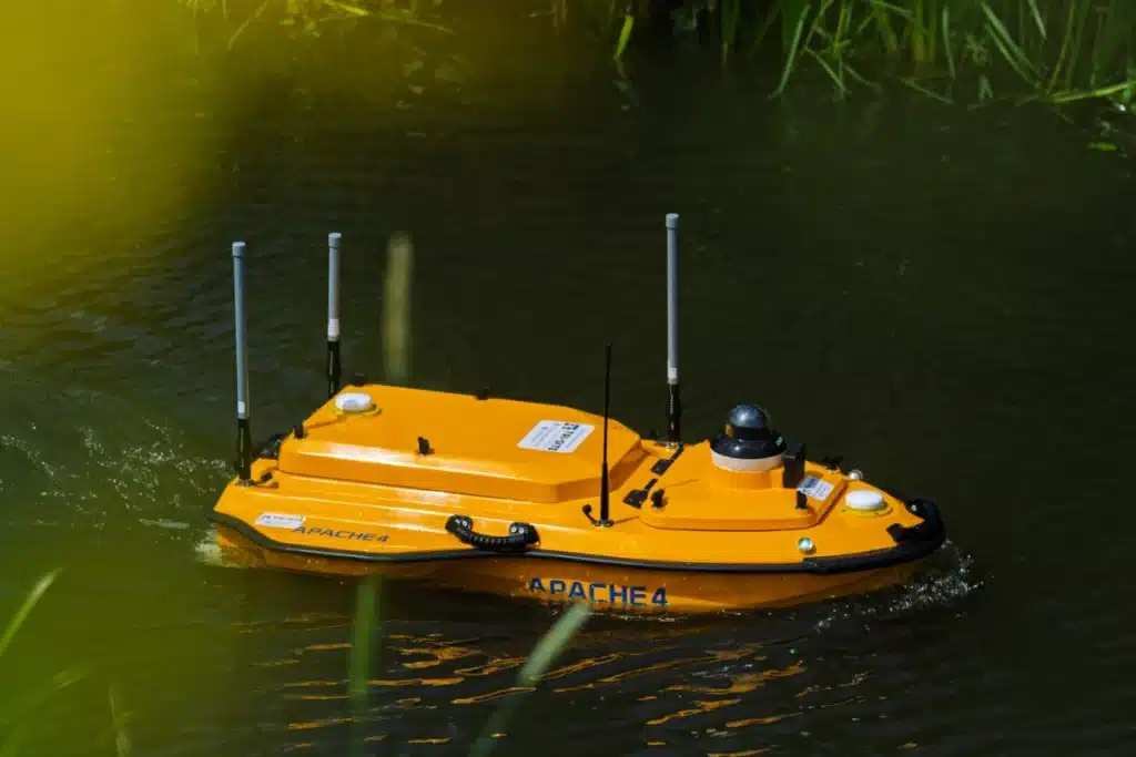
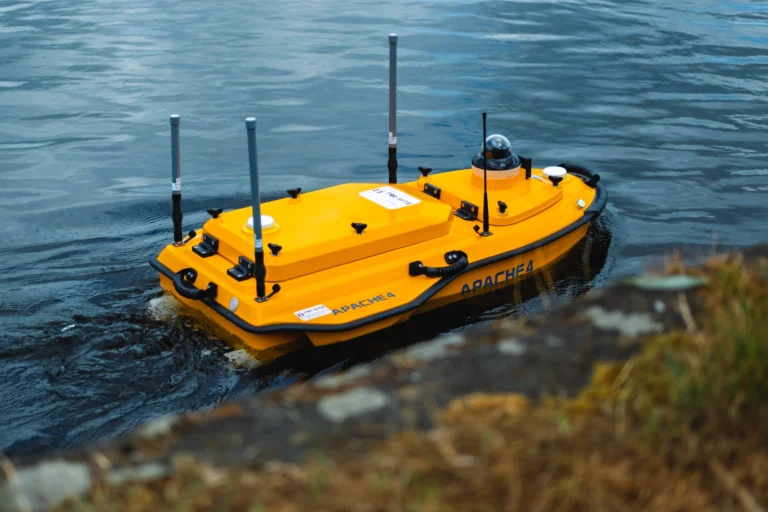
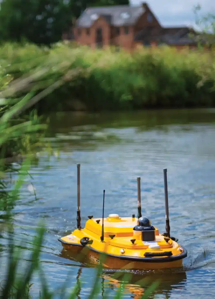
Our Bathymetric Survey Platform — CHC Navigation Apache 4 USV & Apache 3
Our Bathymetric Survey Platform — CHC Navigation Apache 4 USV
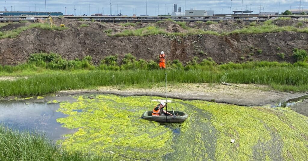
The most significant development in river and watercourse survey methodology in recent years is the unmanned surface vessel — and the Apache 4 from CHC Navigation is the platform we deploy on bathymetric surveys across the North West. The Apache 4 is a remote-operated hydrographic survey platform that captures accurate riverbed and waterway data safely, from the bank, without requiring personnel to enter the water. On fast-flowing rivers, shallow watercourses, flood conditions and ecologically sensitive environments, this matters — both for the safety of the survey team and for the quality of the data. A surveyor wading a river disturbs the bed, affects the data and introduces access and safety risk. The Apache 4 removes all three problems simultaneously.
Apache 4 key capabilities:
Fitted with dual GNSS for precise positioning throughout the survey route. IMU integration for accurate attitude correction on moving water. Single and multibeam echo sounder options — single beam for channel profiles and cross-sections, multibeam for full bed coverage and detailed bed feature mapping. Autonomous route navigation — the vessel follows the planned survey lines precisely without requiring manual steering. Real-time data streaming to the operator on the bank. Suitable for rivers, reservoirs, canals, lakes and coastal environments.
For complex watercourses, narrow channels or environments where the USV cannot operate, we supplement with traditional rod and wading surveys using CHCNAV and Leica GPS instrumentation — always choosing the method that produces the most complete and accurate data for the environment.
Flood Alleviation & River Survey Services.
Flood Alleviation & River Survey Services.
We provide comprehensive bathymetric and river survey services, including:
Surveying flood plains, doorstep levels and surrounding terrain to support flood mitigation schemes.
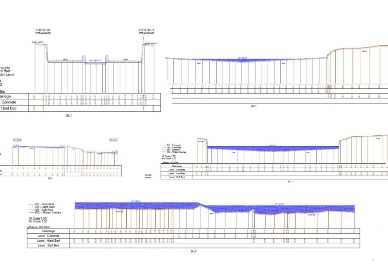
Detailed long and cross sections including: hard and soft bed levels, bank profiles, channel geometry & adjacent topographical data
Surveying flood embankments, walls and defence structures, including flood level contour chasing.
Surveying hydraulic structures including: bridge soffit levels, culvert dimensions, tunnel profiles, point clouds and elevations & integrated topographical mapping
What We Capture in a Bathymetric Survey and River Survey
What We Capture in a Bathymetric Survey and River Survey
A bathymetric and river survey from Site Surveying Services captures the complete picture — watercourse and surrounding terrain — as a single integrated dataset. All survey data is tied to OS National Grid and reduced to Ordnance Datum (AOD) as standard — compatible with all hydraulic modelling platforms.
Riverbed levels
Hard and soft bed levels across the channel at the survey cross-section spacing required by your hydraulic model. Distinguishing between hard bed (rock, gravel, consolidated material) and soft bed (mobile sediment, silt) where relevant to the application.
Longitudinal sections
Thalweg profile along the course of the river capturing the overall gradient, pool and riffle sequences and significant bed features.
Channel cross-sections
Detailed profiles across the watercourse at regular intervals, capturing the full geometry of the channel from bank to bank — bank heights, bank profiles, low water edge, channel width and depth.
Water surface levels
Measured at the time of survey and referenced to OS Datum (AOD), providing the baseline against which modelled flood levels are validated.
Flood plain levels
Adjacent ground levels extending from the bank to the limit of the flood plain, captured using GPS ground survey and integrated with the bathymetric data to produce a continuous terrain model from the upland to the channel bed.
Hydraulic structures
Bridge soffit levels, culvert dimensions, weir crest levels, sluice gate positions, tunnel profiles and all in-channel structures that affect flow hydraulics. Point clouds and elevations produced for complex structures using laser scanning where required.
Flood defence features
Embankment profiles, wall heights, flood gate positions and defence crest levels for schemes involving existing flood defence infrastructure.
EA-compliant deliverables and hydraulic model exports
Every bathymetric survey we produce is delivered to Environment Agency standards — in the format your hydraulic engineer or flood risk consultant requires to move directly into modelling without reprocessing.
All deliverables include a full methodology statement confirming the survey method, the equipment used, the water level at the time of survey, the accuracy achieved, the coordinate system and the date of survey.
EA-compliant long and cross sections
Produced to EA standard format, suitable for submission with planning applications and flood risk assessments.
HEC-RAS export
geometry files in HEC-RAS compatible format for direct import into HEC-RAS 1D and 2D models.
ISIS / InfoWorks export
cross-section data in ISIS and InfoWorks ICM compatible format for 1D and integrated 2D-1D hydraulic models.
EACSD format
Environment Agency Cross Section Database format for EA-managed river models and scheme assessments.
Digital terrain models
Continuous terrain models combining topographic and bathymetric data, in ASCII grid, GeoTIFF or other GIS-compatible formats for 2D hydraulic modelling.
CAD drawings
Cross-section and longitudinal profile drawings in AutoCAD DWG or DXF, clearly annotated and ready for design and reporting use.
PDF plans and profiles
Professionally presented survey drawings for planning submissions, flood risk assessments and client reporting.
Point cloud data
For complex structures including bridges, culverts and weirs, laser scan point clouds in RCP, RCS, E57 or LAS format.
Who Commissions Bathymetric Surveys and River Surveys From Us?
Flood risk engineers and consultants
Level 1, 2 and 3 Flood Risk Assessments for development near watercourses. Sequential and exception tests for sites in flood zones 2 and 3. We understand what flood risk consultants need and we produce data that integrates directly with your hydraulic models.
Hydraulic modelling engineers
New model builds and model updates for EA flood mapping, flood alleviation scheme design and drainage design. EA-compliant cross sections and digital terrain models compatible with HEC-RAS, InfoWorks ICM and ISIS delivered as standard.
Environment Agency supply chain
Flood risk management, river maintenance and asset inspection surveys for EA framework programmes across the North West. We hold Constructionline Gold, RICS regulation and CDM compliance — the accreditation profile required for EA and LLFA supply chains.
Civil engineers and infrastructure consultants
Bridge structural assessments requiring bathymetric survey of the watercourse at the bridge site. Riverbed level, scour assessment data and channel geometry captured alongside the structural survey of the bridge itself.
Environmental consultancies
Environmental monitoring surveys, habitat assessment and conservation management programmes where accurate watercourse data is required. The Apache 4 captures data without entering the water — essential for ecologically sensitive and protected watercourses.
Local authorities and drainage engineers
Drainage design and surface water flood risk assessment for development sites and public realm programmes near watercourses. Flood contour mapping and flood plain level data.
Water companies and AMP8 supply chain
Channel surveys at water infrastructure assets including treatment works, pumping stations, reservoirs and intake structures across the United Utilities network in the North West.
Canal and waterway managers
Capacity surveys, dredging pre- and post-surveys, and condition assessments on canal and navigation infrastructure.
Land Surveying Services
Bathymetric Surveys and River Surveys for Your Sector
our bathymetric survey and River survey case studies
Gathurst Weir — Return Survey Following Fish Pass Installation, Wigan
In 2020 we surveyed Gathurst Weir near Wigan for the first time, capturing a complete bathymetric record of the weir structure and its surrounding watercourse. Three years later, we returned following the installation of a major fish pass — capturing updated bathymetric data and comparing it directly against our 2020 baseline to produce a clear before-and-after record of the watercourse change for the environmental client. The return survey demonstrated exactly what long-term data continuity from a trusted survey partner delivers — not just a point-in-time record, but a documented comparison that proved the environmental intervention had performed as intended.
Flood Defence Topographic and Bathymetric Survey — River Mersey, Didsbury
Following severe flooding from the River Mersey, a hotel and spa in Didsbury required detailed topographic and bathymetric survey to inform the design of new flood defences. Our team captured precise elevation data, land contours, drainage paths, riverbank profiles and watercourse geometry across the site and surrounding area. The combined topographic and bathymetric dataset gave the flood risk design team a complete picture of the existing conditions — above and below water — for the flood defence design programme.
Our Services
How Bathymetric Surveys and River Surveys Integrate with Other Services
How Bathymetric Surveys and River Surveys Integrate with Other Services
Bathymetric and topographic surveys are the most important combination for flood risk and river management applications. Ground survey above the waterline combined with bathymetric data below it, producing a continuous terrain model from the flood plain to the riverbed. Essential for hydraulic model builds and flood risk assessments. Our Didsbury flood defence survey demonstrates this integrated approach. Bathymetric survey and laser scanning involves significant hydraulic structures — bridges, culverts, weirs, sluice gates and tunnel portals — combining bathymetric data with laser scanning of the structure produces a complete geometric record of both the watercourse and the infrastructure within it. Point clouds of bridge soffits, culvert apertures and weir faces delivered alongside the cross-section data. Bathymetric survey and UAV survey are for large flood plain surveys and river corridor assessments, combining UAV LiDAR for the floodplain terrain with bathymetric data for the channel produces a seamless, continuous terrain model from the upland across the flood plain to the channel bed. Essential for 2D hydraulic model domains covering wide floodplain extents.
Topographical Surveys
OS-controlled accurate, efficient and cost effective surveys for highways, civils and development. Cad and BIM-ready output.
PAS 128 utility mapping
Providing the location of underground services in 2D or 3D through qualified utility mapping surveys, using advanced GPR and Electromagnetic Location.
Measured building survey
Delivering accurate as-built information that supports design, refurbishment, planning and construction with the latest technology. Producing reliable drawings and digital models.
Laser Scanning
3D laser scanners capture millions of points per second, creating a point cloud which enables the finer details and the physical site to be viewed remotely.
Mobile mapping
For highway engineers, infrastructure managers, local authorities and contractors working on live road schemes, mobile mapping is now the standard for corridor surveys.
3D Machine control
With decades of supporting major earthworks contractors and large-scale infrastructure schemes, we provide reliable machine control across Lancashire and the wider UK.
Setting out engineers
With strong, long-standing relationships across the civil engineering and construction sector, we supply skilled professionals who keep your projects accurate, efficient and on programme.
bathymetric surveys & river surveys
Using modern technology, we capture detailed underwater and river channel information safely and efficiently – delivering reliable data you can trust.
Stockpile surveys & volumetric analysis
Whether a one-off stockpile measurement or regular monitoring, we deliver reliable, repeatable data tailored to your project using advanced technology.
Control Network Installation
Delivering robust and precise site control systems to support every stage of construction in developments, infrastructure schemes or major earthworks.
aerial & drone surveys
CAA-approved drone operations for aerial mapping, photogrammetry and volumetric analysis, providing a comprehensive view of terrain, structures and landscapes.
3D BIM Modelling
Whether you require an as-built Revit model, federated coordination model or detailed digital twin, our team delivers high quality, design-ready outputs.
survey equipment hire
We offer a vast range of surveying and engineering equipment for hire and will always try to beat a comparable quote. Discover the fleet.
monitoring
Providing reliable monitoring surveys across the UK, delivering precise data that supports risk management, compliance and informed decision making throughout a project lifecycle.
Virtual Tour 3D
An immersive experience which instantly transports your clients to your business, guiding them through your space and creating a seamless experience.
Impermeable area surveys
We deliver georeferenced impermeable area data that drainage engineers and planning consultants can work from directly.
CCTV & Drainage surveys
Acoustic & Noise Assessments
We deliver acoustic and noise assessments, supporting planning applications, discharge of conditions and Environmental Impact Assessments.
Topographical Surveys
PAS 128 utility mapping
Laser Scanning
Mobile mapping
Setting out engineers
bathymetric surveys & river surveys
Control Network Installation
aerial & drone surveys
survey equipment hire
monitoring
Impermeable area surveys
CCTV & Drainage surveys
3D Machine control
Acoustic & Noise Assessments
Stockpile surveys & volumetric analysis
3D BIM Modelling
3D BIM Modelling
Virtual Tour 3D
Why choose site surveying services
On site. On spec. On time.
Nobody enters the water. Zero Safety Risk.
The Apache 4 USV captures bed level data from the bank. Zero personnel in the water. Zero ecological disturbance. Zero safety risk from fast-flowing or unstable watercourses.
EA-compliant deliverables. Confirmed before we start.
HEC-RAS, InfoWorks ICM, ISIS, EACSD — the format confirmed with the hydraulic engineer before mobilisation. Not adapted after delivery. Specified and delivered as required.
Maintained datums for return surveys.
Permanent ground markers installed where the programme anticipates return visits. The before-and-after comparison that only works when the datum has been maintained.
Frequently Asked Questions
Frequently Asked Questions
What is a bathymetric survey?
A bathymetric survey measures the depth and underwater profile of a water body — a river, reservoir, canal, lake or coastal environment. It captures riverbed levels, channel geometry, underwater features and the profile of the watercourse in the same way that a topographic survey maps land. Combined with topographic survey of the surrounding land, bathymetric data produces a complete terrain model from the flood plain to the channel bed — the foundation for hydraulic modelling, flood risk assessment and river engineering.
What is the difference between a river survey and a bathymetric survey?
Bathymetric survey refers specifically to the measurement of water depth and bed levels within a water body — the below-water element of the survey. A river survey is broader — it includes the bathymetric channel data, the topographic bank and flood plain survey, the hydraulic structure capture and the water surface level measurement. At Site Surveying Services, when we refer to a river survey we mean the complete integrated programme — above and below water — delivered as a single coordinated dataset.
When is a river survey required for a planning application?
A river survey is required for any planning application that involves a Level 2 or Level 3 Flood Risk Assessment on a site near a watercourse — typically sites in Flood Zone 2 or Flood Zone 3 where the sequential test and exception test require a hydraulic model of the adjacent watercourse. It may also be required for drainage strategies on sites near ordinary watercourses where the Lead Local Flood Authority requires evidence of existing channel capacity. We advise on whether a river survey is required for your specific site and FRA level at the time of enquiry.
When is a bathymetric survey required for a flood risk assessment?
A bathymetric survey is required for any Flood Risk Assessment that involves building or calibrating a hydraulic model of the watercourse adjacent to the development site. This is typically required for Level 2 and Level 3 FRAs on sites in Flood Zone 2 or Flood Zone 3 where the sequential test and exception test require a hydraulic model to demonstrate that the development will not increase flood risk. The survey provides the channel geometry data — cross-sections, bed levels, bank profiles and hydraulic structure dimensions — that the hydraulic model requires. For Level 1 screening assessments, desktop data may be sufficient; we advise on the appropriate survey scope at the time of enquiry.
What is the Apache 4 and why do you use it?
The Apache 4 is an unmanned surface vessel from CHC Navigation — a remote-operated hydrographic survey platform that captures riverbed and waterway data from the bank without requiring personnel to enter the water. It is fitted with dual GNSS, IMU integration and single or multibeam echo sounders, and navigates survey routes autonomously. We use it because it is safer, more accurate and less ecologically disruptive than traditional wading surveys, particularly on fast-flowing rivers, flood-swollen watercourses and ecologically sensitive environments where disturbing the riverbed would damage the habitat or affect data quality.
What hydraulic modelling software are your deliverables compatible with?
Our bathymetric survey deliverables are compatible with all major hydraulic modelling platforms — HEC-RAS (1D and 2D), ISIS, InfoWorks ICM, TUFLOW and EACSD. We produce EA-compliant cross section data and export files in the format your hydraulic engineer requires, ready for direct import without reprocessing. If your project uses a specific hydraulic modelling platform, confirm this at the time of instruction and we will build the required export format into the deliverable specification.
What is the difference between single beam and multibeam echo sounding?
Single beam echo sounding fires one acoustic pulse directly below the vessel at a time, measuring the depth along a single line — producing accurate cross-section profiles at the survey line positions. It is the standard method for river cross-section surveys for hydraulic modelling. Multibeam echo sounding fires multiple acoustic pulses simultaneously in a fan pattern, producing a continuous swath of depth measurements across the full width of the channel — mapping the entire bed rather than just the survey lines. Multibeam is appropriate where full bed coverage and bed feature mapping are required — for dredging surveys, scour assessments and detailed reservoir capacity surveys. We advise on the appropriate method for your application at the time of scoping.
Can you survey a river in flood or high flow conditions?
The Apache 4 USV is capable of operating in higher flow conditions than traditional wading surveys — the vessel maintains accurate positioning through its GNSS and IMU system regardless of current speed. There are limits — extreme flood conditions, very fast flow rates and highly turbulent reaches will restrict or prevent survey. We assess conditions at the time of scoping and confirm operability for your specific watercourse and programme window. In some cases, programming the survey for a lower-flow period is necessary to achieve the required data quality.
Do you survey reservoirs and canals as well as rivers?
Yes. The Apache 4 is equally applicable to reservoir, canal and lake survey as it is to rivers. For reservoir capacity surveys, the USV maps the full bed at close line spacing to produce an accurate volume calculation. For canal condition surveys, it captures channel profile, bed levels and underwater features along the navigation. For lakes and standing water bodies, full bed mapping using multibeam echo sounding produces a complete bathymetric model of the water body.
What accuracy do your bathymetric surveys achieve?
Vertical accuracy of ±50–100mm on bed level measurements is standard for single beam surveys with good GNSS positioning, which is appropriate for all hydraulic modelling applications. Where higher accuracy is required for structural assessment or precision engineering, we can increase the specification. All surveys are produced with a full methodology statement confirming the accuracy achieved, the water level at the time of survey and the GNSS positioning method used.
Can you survey a river during high flow conditions?
The Apache 4 USV is capable of operating in higher flow conditions than traditional wading surveys — maintaining accurate positioning through its GNSS and IMU system regardless of current speed. There are limits — extreme flood conditions, very fast shallow flow and highly turbulent reaches will restrict or prevent survey. We assess flow conditions at the time of scoping and confirm operability for your specific watercourse and programme window. Where a lower-flow survey window is needed to achieve the required data quality, we advise on the appropriate timing.
How do you handle hydraulic structures — bridges, culverts and weirs?
Hydraulic structures require survey methodology beyond the standard bathymetric survey. Bridge soffit levels, arch profiles and pier geometry are surveyed using GPS and total station from the bank and on the structure. Culvert dimensions, invert levels and condition are captured using GPS, tape measurement and, where access permits, laser scanning. Weir crest levels, face geometry and downstream scour are captured using the combination of GPS survey, the USV and laser scanning where appropriate. We produce a complete geometric record of all hydraulic structures encountered in the survey reach, integrated with the cross-section and bed level data.
Do you produce flood contour maps from bathymetric survey data?
Yes. Where the project requires flood contour mapping — for planning applications, flood risk assessments or flood alleviation scheme design — we produce flood level contours from the combined topographic and bathymetric terrain model at the modelled flood levels specified by the hydraulic engineer. Contour maps are produced in CAD and GIS formats compatible with your reporting and planning documentation requirements.
What areas do you cover?
Our head office is in Clitheroe, Lancashire, with offices in Matlock, Newcastle and Bristol. We deliver bathymetric surveys across the North West — the Ribble, Lune, Wyre, Mersey, Irwell, Calder, Hodder and their tributaries — and nationally. We have extensive experience of Lancashire and North West watercourses and understand the river environments, the regulatory context and the flood risk characteristics of the region. All work is carried out by our directly employed team.