


 Leeds
Leeds Doncaster
 Sheffield
 Bradford
 Hull
Hull Halifax
 Sunderland
 Newcastle
 Middlesborough
 Yorkshire Moors
 Teesside
 Cumbria
 Harrogate
 York
York Yorkshire Dales
 Northumberland
 Goole
Goole Carlisle
 Keswick
 Kendal
 Barrow-in-Furness
 Lancaster
 Blackpool
 Morecambe
 Southport
 Liverpool
 Wigan
Wigan Manchester
 Blackburn
 Burnley
 Forest of Bowland
 Oldham
 Chester
 Stockport
 Peak District
 Skipton
 Crewe
Crewe Rotherham
 Stoke
Stoke Driffield
Land and engineering surveyors based in Lancashire
Aerial and Drone Surveys
Drone Surveys Lancashire
Professional Aerial & Drone Surveying Services Across the UK
Professional Aerial & Drone Surveying Services Across the UK
What is Drone Surveying?
Aerial and drone surveying uses unmanned aerial vehicles (UAVs) equipped with specialised sensors to capture data from above the ground. These aircraft collect high-accuracy measurements which can be processed into:
This aerial approach provides a comprehensive view of terrain, structures and landscapes – often faster, safer, and more cost-effective than traditional ground methods.
CAA compliance and our pilot qualifications
CAA compliance and our pilot qualifications
Every UAV survey we undertake is fully CAA-compliant. Our pilots hold:
PDRA01 Operational Authorisation
the Civil Aviation Authority standard operational authorisation for commercial drone operations in the UK. Required for all commercial UAV survey operations.
General Visual Line of Sight Certificate (GVC)
the pilot qualification underpinning the PDRA01 authorisation.
All UAV operations are covered by our professional indemnity insurance.
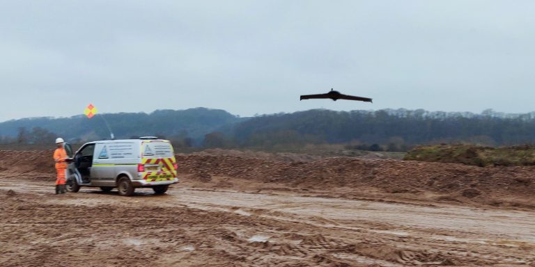
We produce a full operational risk assessment and flight plan for every survey — identifying airspace restrictions, ground hazards, operational constraints and emergency procedures before any flight takes place. Where survey locations fall within controlled airspace or require additional permissions, we manage the CAA notification and permission process.
Aerial surveys lancashire
Types of Drone Surveying We Provide
Types of Drone Surveying We Provide
Site Surveying Services offers a range of aerial survey solutions to match your project needs. every survey is OS-controlled, tied to National Grid and delivered in the format your design software requires — whether that is AutoCAD DWG, Revit, or a GIS-compatible output. All features of a topographical survey are surveyed to the accuracy specified and delivered with a clear methodology statement confirming the equipment used, the coordinate system, the accuracy achieved and the date of survey. We deliver comprehensive land and engineering topographical surveys using the latest surveying technology to ensure precision and efficiency.
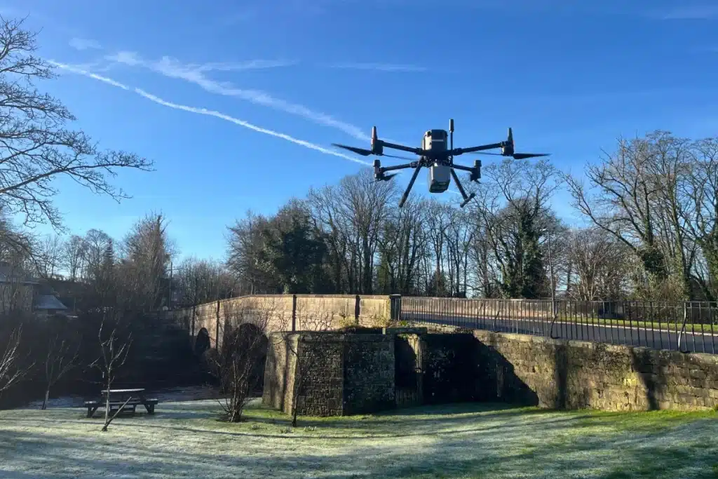
Our UAV platform — CHCNAV X500
Combined LiDAR & Photogrammetry
Photogrammetry uses high-resolution cameras mounted on drones to capture overlapping images which are processed into detailed maps. For projects that require both the terrain accuracy of LiDAR and the visual detail of photogrammetry, we operate both payloads in a single survey programme — producing a complete dataset of ground elevation, 3D point cloud and photorealistic imagery from one mobilisation.
Best for: complex sites requiring both terrain accuracy and visual documentation, major infrastructure and development surveys, environmental impact assessment.
UAV LiDAR
Surveying
UAV LiDAR
Surveying
LiDAR (Light Detection and Ranging) uses laser pulses to measure distances and build highly precise 3D models of the ground and surface features.
Ideal For:
- Large sites with vegetation cover
- Terrain modelling & contour mapping
- Infrastructure development & alignment
- Volumetric and stockpile measurement
Benefits Are:
- Penetrates vegetation for ground surface modelling
- Generates accurate point clouds with centimetre-level precision
- Faster data capture than traditional methods
Aerial Photogrammetry
Aerial Photogrammetry
Photogrammetry uses high-resolution cameras mounted on drones to capture overlapping images which are processed into detailed maps.
Ideal For:
- Orthophoto maps
- Surface modelling
- Visual site documentation
- Planning and volume measurement
Benefits Are:
- Cost-effective for medium-range surveys
- Excellent visual detail and texture mapping
- Outputs integrate with GIS and CAD systems
Using drones for survey data collection delivers major advantages over conventional techniques
Why Choose Drone Surveys?
Why Choose Drone Surveys?
Speed & Efficiency
Drones can cover large areas rapidly and return data for processing within a short time frame - often reducing weeks of fieldwork to a single flight.
Accuracy & Detail
Advanced sensors like LiDAR and RTK-enabled cameras deliver centimetre-level accuracy, producing reliable outputs for critical decision-making.
Safety & Access
UAVs capture data from above, reducing the need for surveyors in hazardous or hard-to-reach areas - improving safety and lowering risk.
Cost-Effective
Compared to manned aerial surveys or extensive ground crews, drone surveys are more cost-efficient while providing high-quality deliverables.
Deliverables & Output Formats
Deliverables & Output Formats
What drone surveys deliver
Dense 3D point cloud
LiDAR or photogrammetric point cloud in LAS, LAZ or E57 format, georeferenced to OS National Grid.
Digital Terrain Model (DTM)
bare earth surface model with vegetation and above-ground structures removed. The primary deliverable for flood risk modelling, drainage design and topographic analysis.
Digital Surface Model (DSM)
surface model including vegetation heights and structure — useful for habitat assessment, tree survey and visual impact analysis.
Orthomosaic imagery
geometrically corrected, georeferenced aerial photography of the site. GeoTIFF format, compatible with GIS and CAD platforms.
Volumetric analysis
cut and fill calculations, stockpile volumes and earthworks reconciliation from the point cloud, delivered in CAD, PDF or spreadsheet format.
Contours and topographic plans
CAD drawings in DWG or DXF format extracted from the DTM, at the contour interval and scale your design requires.
GIS-compatible datasets
all outputs available in formats compatible with QGIS, ArcGIS and other GIS platforms on request.
our Drone survey case studies
Drone Surveys in the Utilities Sector — Infrastructure Management
How UAV survey is transforming safety, efficiency and data accuracy on utilities infrastructure programmes — reducing the need for personnel in hazardous environments, delivering faster survey data and producing higher-density datasets than conventional ground survey on complex utility corridor programmes.
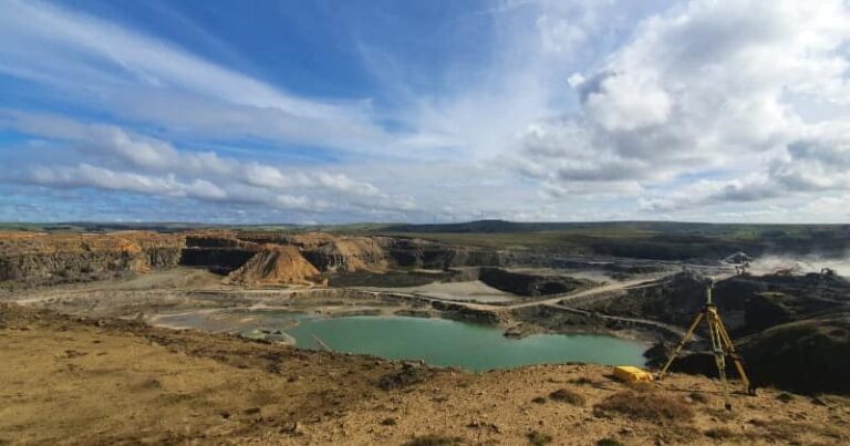
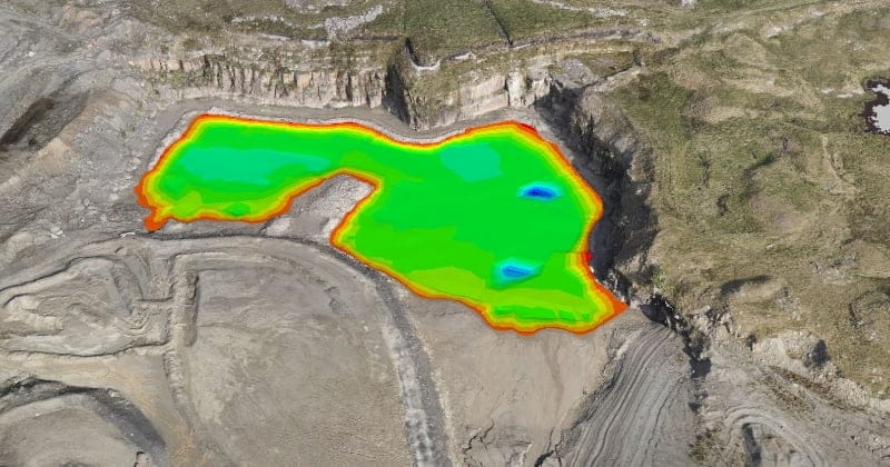
Elevating Quarry Operations — UAV Survey for Safety and Commercial Accuracy
Our Services
How Aerial & Drone Surveys Integrate With Other Services
How Aerial & Drone Surveys Integrate With Other Services
Topographical Surveys
OS-controlled accurate, efficient and cost effective surveys for highways, civils and development. Cad and BIM-ready output.
PAS 128 utility mapping
Providing the location of underground services in 2D or 3D through qualified utility mapping surveys, using advanced GPR and Electromagnetic Location.
Measured building survey
Delivering accurate as-built information that supports design, refurbishment, planning and construction with the latest technology. Producing reliable drawings and digital models.
Laser Scanning
3D laser scanners capture millions of points per second, creating a point cloud which enables the finer details and the physical site to be viewed remotely.
Mobile mapping
For highway engineers, infrastructure managers, local authorities and contractors working on live road schemes, mobile mapping is now the standard for corridor surveys.
3D Machine control
With decades of supporting major earthworks contractors and large-scale infrastructure schemes, we provide reliable machine control across Lancashire and the wider UK.
Setting out engineers
With strong, long-standing relationships across the civil engineering and construction sector, we supply skilled professionals who keep your projects accurate, efficient and on programme.
bathymetric surveys & river surveys
Using modern technology, we capture detailed underwater and river channel information safely and efficiently – delivering reliable data you can trust.
Stockpile surveys & volumetric analysis
Whether a one-off stockpile measurement or regular monitoring, we deliver reliable, repeatable data tailored to your project using advanced technology.
Control Network Installation
Delivering robust and precise site control systems to support every stage of construction in developments, infrastructure schemes or major earthworks.
aerial & drone surveys
CAA-approved drone operations for aerial mapping, photogrammetry and volumetric analysis, providing a comprehensive view of terrain, structures and landscapes.
3D BIM Modelling
Whether you require an as-built Revit model, federated coordination model or detailed digital twin, our team delivers high quality, design-ready outputs.
survey equipment hire
We offer a vast range of surveying and engineering equipment for hire and will always try to beat a comparable quote. Discover the fleet.
monitoring
Providing reliable monitoring surveys across the UK, delivering precise data that supports risk management, compliance and informed decision making throughout a project lifecycle.
Virtual Tour 3D
An immersive experience which instantly transports your clients to your business, guiding them through your space and creating a seamless experience.
Impermeable area surveys
We deliver georeferenced impermeable area data that drainage engineers and planning consultants can work from directly.
CCTV & Drainage surveys
Acoustic & Noise Assessments
We deliver acoustic and noise assessments, supporting planning applications, discharge of conditions and Environmental Impact Assessments.
Why choose site surveying services
On site. On spec. On time.
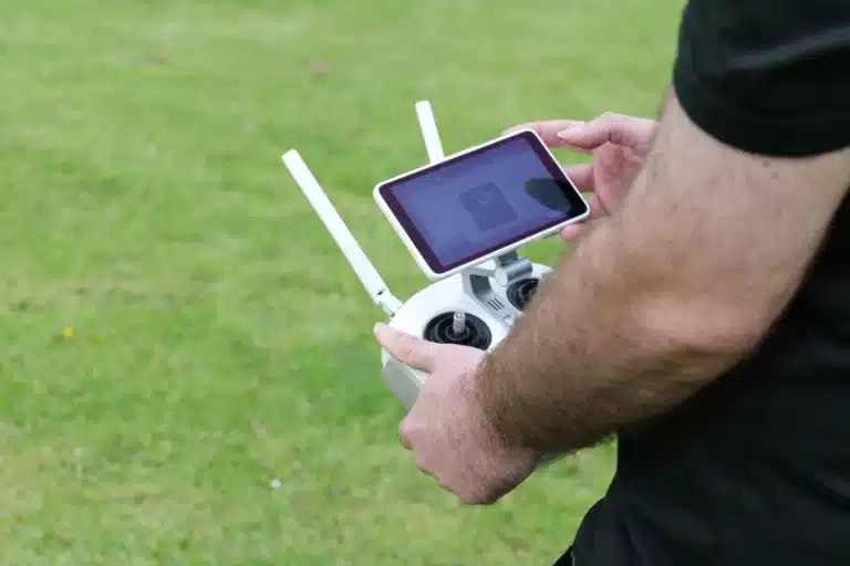
Surveyors & Pilots
Our UAV operators understand the data they are capturing, the coordinate systems required and the downstream use it needs to support. Not commercial drone operators with survey capability. Survey professionals with a CAA licence.
PDRA01 and GVC certified. CAA approved.
The full commercial UAV certification for every flight. Method statements and traffic management plans produced for every operation on or near a public highway, rural environments or populated area.
LiDAR penetrates what photogrammetry cannot.
UAV LiDAR reaches the ground surface beneath vegetation. Where the DTM needs to reflect the bare earth — not the top of the canopy — LiDAR is the right method. We advise on which is right for your application.
Ground control on every flight.
GPS ground control points established before every survey, tying the aerial data to OS National Grid. The georeferencing that makes aerial data compatible with your design and GIS environment.
Frequently Asked Questions
Frequently Asked Questions
What is a UAV or drone survey?
A UAV (Unmanned Aerial Vehicle) survey uses a drone equipped with specialist sensors — LiDAR, cameras, or both — to capture accurate spatial data from the air. The aircraft flies a planned route above the survey area, with the sensors capturing data continuously throughout the flight. The raw data is then processed to produce deliverables including point clouds, DTMs, orthomosaic imagery and volumetric analysis. UAV survey produces georeferenced, survey-grade data at high speed across areas that would take significantly longer to survey by ground-based methods.
What is the difference between UAV LiDAR and photogrammetry?
UAV LiDAR uses laser pulses to measure distances directly — it penetrates vegetation to reach the ground surface and produces accurate terrain data in vegetated environments. UAV photogrammetry uses overlapping photographs processed into a point cloud and surface model — it produces excellent visual detail and texture but cannot penetrate vegetation, so the DSM captures the top of the vegetation rather than the ground beneath it. LiDAR is required for DTM production in vegetated areas. Photogrammetry is appropriate for open terrain, construction sites, heritage recording and applications where visual detail matters alongside the geometry.
What is a DTM and what is it used for?
A DTM (Digital Terrain Model) is a model of the bare earth surface — processed from LiDAR data with vegetation and above-ground structures removed. It represents the ground surface as it would appear without trees, buildings or other above-ground features. DTMs are the primary deliverable for flood risk modelling, drainage design, earthworks design and environmental assessment — these applications need the ground surface, not the surface of the vegetation above it. A DSM (Digital Surface Model) includes vegetation heights and structures and is used for habitat assessment, visual impact analysis and applications where the height of above-ground features is relevant.
How accurate is a UAV LiDAR survey?
With good ground control — GPS ground control points established by our survey team before the flight — UAV LiDAR achieves ±50–100mm vertical accuracy and ±50mm horizontal accuracy as standard. For most topographic, environmental and volumetric applications this is sufficient. Where higher accuracy is required, we increase the ground control density and can confirm the achievable accuracy for your specific site and application at the time of scoping.
What ground control is needed for a UAV survey?
Ground control points (GCPs) are GPS-measured targets placed across the survey area before the flight, visible in the aerial imagery or LiDAR data. They tie the aerial data to OS National Grid and provide the datum against which accuracy is verified. The number and distribution of GCPs depends on the site size, the terrain and the accuracy required. We establish all ground control ourselves before every flight — using CHCNAV and Leica GPS instrumentation. The GCPs are removed after the survey and the positions are retained for any future return surveys tied to the same datum.
Can you fly in controlled airspace?
Our pilots hold PDRA01 Operational Authorisation which covers most standard survey operations. Where a survey location falls within controlled airspace — near airports, in restricted zones or requiring specific CAA permissions — we manage the notification and permission process. In some cases, airspace restrictions will limit operational altitude or require specific flight planning. We identify these constraints during the operational risk assessment and advise at the time of scoping.
What areas do you survey — can you survey large sites?
Yes. UAV survey is particularly well-suited to large sites where ground-based methods would be too slow or impractical. A single UAV LiDAR or photogrammetric flight can cover several hundred hectares. For very large sites, multiple flights may be required — planned and executed as a single survey programme with consistent ground control across the full area. We have surveyed quarry sites, large agricultural estates, infrastructure corridors and extensive environmental sites across Lancashire, the North West and nationally.
How long does a UAV survey take?
For most sites, the field operation takes a single day — ground control establishment, flight and post-flight checks. Processing the raw data to produce the final deliverables typically takes two to five working days depending on the size of the dataset and the deliverables required. We confirm the realistic programme at the time of quoting.
Do you carry out volumetric analysis from UAV data?
Yes. Volumetric analysis from UAV point cloud data is one of our most regularly commissioned services — particularly for quarry operators, earthworks contractors and aggregate site managers who need regular, accurate volume data without stopping operations. We produce cut and fill calculations and stockpile volumes from the point cloud in CAD, PDF or spreadsheet format. Return surveys tied to the same ground control network allow direct comparison between survey dates for programme reconciliation.
Are your drone operators qualified surveyors?
Yes. This is one of the most important distinctions between Site Surveying Services and a commercial drone operator. Our UAV pilots are qualified surveyors who understand the data they are collecting, the coordinate systems and ground control methodology required to produce survey-grade output, and the downstream use the data needs to support. A commercial drone pilot produces imagery. Our UAV surveyors produce survey data — georeferenced, documented and ready to use in your design or commercial environment.