


 Leeds
Leeds Doncaster
 Sheffield
 Bradford
 Hull
Hull Halifax
 Sunderland
 Newcastle
 Middlesborough
 Yorkshire Moors
 Teesside
 Cumbria
 Harrogate
 York
York Yorkshire Dales
 Northumberland
 Goole
Goole Carlisle
 Keswick
 Kendal
 Barrow-in-Furness
 Lancaster
 Blackpool
 Morecambe
 Southport
 Liverpool
 Wigan
Wigan Manchester
 Blackburn
 Burnley
 Forest of Bowland
 Oldham
 Chester
 Stockport
 Peak District
 Skipton
 Crewe
Crewe Rotherham
 Stoke
Stoke Driffield
Surveying Services north east
Site Surveying Services in Durham & County Durham
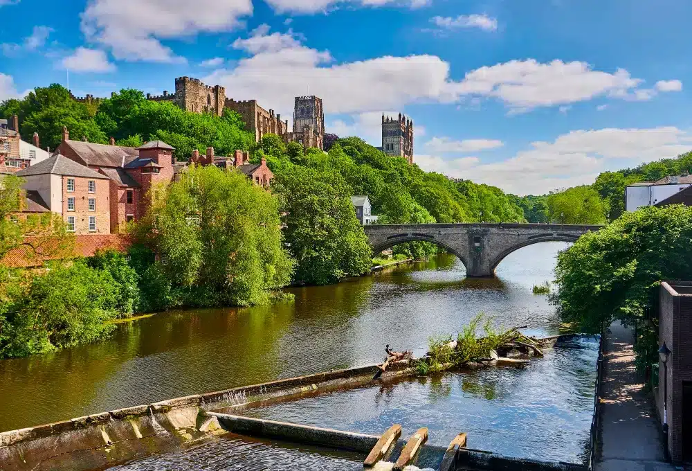
Durham is one of England’s most remarkable cities — a UNESCO World Heritage Site dominated by its Norman cathedral and castle, perched dramatically above the River Wear, and surrounded by one of the largest county council areas in England. County Durham stretches from the urban former coalfield communities of Chester-le-Street and Stanley in the east to the open moorland of the North Pennines AONB in the west — an area of enormous geographic and economic diversity, with a development and regeneration agenda to match.
Site Surveying Services delivers professional surveying services across Durham and County Durham, with our teams travelling regularly to the county on survey commissions. Based in Clitheroe, we cover the whole of the North East as part of our nationwide operations — bringing the same technology, methodology, and commitment to accuracy that our North West clients rely on to projects across Durham, County Durham, and the wider region.
Whether your project is in Durham city, on the A1(M) corridor, in the former coalfield communities, or on the county’s upland moorland fringe, our team is equipped and ready to deliver.
Our Surveying Services in Durham & County Durham
We offer a comprehensive range of professional surveying services to clients across Durham and County Durham:
Topographic Surveys Durham
detailed land and site surveys for planning applications, infrastructure, flood risk, and development across the county
Measured Building Surveys Durham
precise floor plans, elevations, and sections for heritage buildings, commercial properties, and residential developments
3D Laser Scanning Durham
high-density point cloud surveys for heritage assets, complex structures, and BIM production
Infrastructure Surveys Durham
bridge surveys, highway surveys, and infrastructure assessments across County Durham's extensive road and river network
Sectors We Serve in Durham & County Durham
Public Sector & Regeneration Durham
surveys for Durham County Council, local authorities, and public sector partners
Infrastructure & Highways Durham
bridge surveys, highway assessments, and infrastructure surveys across County Durham's extensive network
Commercial & Industrial Durham
surveys for commercial development, industrial estates, and employment land
Education & Healthcare Durham
surveys for Durham University's extensive estate and the county's health and education facilities
Residential Development Durham
topographic and utility surveys for housing schemes across the county's urban and rural communities
Heritage & Conservation Durham
surveys of Durham's exceptional UNESCO World Heritage Site buildings, listed structures, and historic assets across the county
Surveying Case Studies & Project Highlights in Durham
Case Studies & Project Highlights
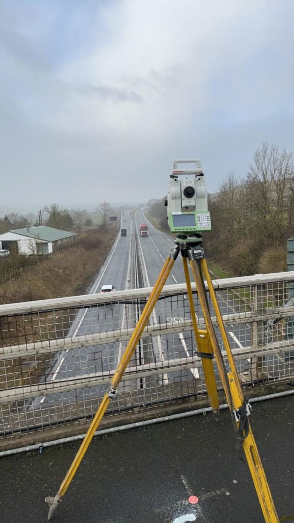
Bridge Survey, Barnard Castle — Infrastructure Survey
No signs of anyone testing their eyesight near Barnard Castle on this particular visit — just our team, our instrument, and a survey to complete. Positioned on a bridge over the A1(M) corridor near Barnard Castle, our surveyor completed a comprehensive survey of the structure and its surroundings, with passing vehicles slowing down at the sight of the flashing instrument — our instrument, to be clear.
Barnard Castle sits at the heart of the Teesdale valley in the far west of County Durham — a market town of considerable historic character overlooking the River Tees, and a long way from our Clitheroe base. It’s a journey worth making. Bridge and infrastructure surveys of this kind provide the precise dimensional and condition data that highway authorities and infrastructure managers need to make informed maintenance and investment decisions. There was definitely some surveying done.
Durham & County Durham's Development Landscape
Durham & County Durham's Development Landscape
County Durham is one of England’s most significant county council areas — a unitary authority covering 863 square miles and a population of over 520,000, with a development agenda that balances the regeneration of its former coalfield communities with the conservation of its outstanding natural and historic environment. Durham City itself is a UNESCO World Heritage Site, and the county contains significant areas of the North Pennines AONB — one of England’s largest protected landscapes. Alongside this heritage and environmental framework, County Durham has ambitious plans for housing growth, economic diversification, and the regeneration of communities across the former coalfield. The current planning framework for County Durham is the County Durham Plan, adopted 21 October 2020, which sets out the vision for housing, employment, and the environment across the county until 2035.
Why Choose Site Surveying Services in Durham & County Durham?
Why Choose Site Surveying Services in Durham & County Durham?
Nationwide reach
we travel regularly across the North East as part of our national operations, bringing the same high standards to County Durham as to our North West home territory
Heritage expertise
Durham's UNESCO World Heritage Site and the county's extensive stock of listed buildings demand the highest levels of survey accuracy and sensitivity; we deliver both
Infrastructure survey capability
bridge surveys, highway assessments, and infrastructure surveys across County Durham's extensive road, rail, and river network
Advanced technology
Trimble X7 and Leica RTC360 scanning, UAV survey, and GPS-controlled total station surveys, all in-house
Full service range
topographic surveys, measured building surveys, laser scanning, utility mapping, setting out, and monitoring all available
Frequently Asked Questions
Frequently Asked Questions
Do you carry out surveys in Durham city and across County Durham?
Yes. We travel regularly to County Durham as part of our nationwide operations, delivering topographic surveys, measured building surveys, infrastructure surveys, and other services across the county. Our Barnard Castle bridge survey is a good example of our reach into the county’s more remote western areas.
Can you survey Durham's UNESCO World Heritage Site buildings and heritage assets?
Yes. Durham Cathedral, Durham Castle, and the city’s wider heritage environment present exactly the kind of survey challenge we are equipped for — using 3D laser scanning to capture accurate, detailed data from complex historic structures with minimal physical intervention.
Do you carry out bridge and infrastructure surveys in County Durham?
Yes. Bridge surveys, highway assessments, and infrastructure surveys across County Durham’s extensive road and river network are within our capability. Our Barnard Castle commission involved a bridge survey on a live highway environment, completed safely and accurately.
How do you manage the travel to County Durham from your base?
County Durham is approximately 90 miles from our Clitheroe base — around 1 hour 45 minutes via the A1(M). We factor travel into our project planning and pricing, and for multi-day commissions we can arrange accommodation locally. All travel costs are included transparently in our quotations.
Do you carry out topographic surveys for planning applications in County Durham?
Yes. We provide topographic surveys across County Durham to support planning applications, drainage assessments, flood risk studies, and development appraisals, delivered in CAD or other agreed formats to planning specification.