


 Leeds
Leeds Doncaster
 Sheffield
 Bradford
 Hull
Hull Halifax
 Sunderland
 Newcastle
 Middlesborough
 Yorkshire Moors
 Teesside
 Cumbria
 Harrogate
 York
York Yorkshire Dales
 Northumberland
 Goole
Goole Carlisle
 Keswick
 Kendal
 Barrow-in-Furness
 Lancaster
 Blackpool
 Morecambe
 Southport
 Liverpool
 Wigan
Wigan Manchester
 Blackburn
 Burnley
 Forest of Bowland
 Oldham
 Chester
 Stockport
 Peak District
 Skipton
 Crewe
Crewe Rotherham
 Stoke
Stoke Driffield
Land and engineering surveyors based in Lancashire
3D BIM Modelling
3d BIM Modelling Lancashire and the North West
Professional Scan to 3D BIM Modelling Across the UK
Professional Scan to 3D BIM Modelling Across the UK
Survey data is only as useful as it is usable. When your project carries a BIM requirement, the survey scope must be built around your Employer’s Information Requirements from the first conversation — not retrofitted at handover when the model does not match the structural engineer’s expectations or the MEP consultant cannot coordinate from it.
Site Surveying Services delivers BIM model creation and scan to BIM services across Lancashire, the North West and nationally — producing Revit models, coordinated datasets and point clouds from laser scan data, in-house, to the LOD your project specifies. Every model is produced by our directly employed team. The surveyor who captured the data and the BIM technician who produced the model are the same organisation — the model you receive has been checked against the scan before it leaves our office. We run CPD sessions for architectural practices on BIM delivery methodology and how survey data integrates with design workflows. Our first session was delivered to Cassidy Ashton in Preston. If your practice would benefit from a session, get in touch.
What is 3D BIM Modelling?
What is 3D BIM Modelling?
BIM (Building Information Modelling) is the process of creating a digital 3D representation of a building or structure that contains both geometric and data-rich information. Unlike traditional 2D drawings, BIM models allow for intelligent coordination, clash detection and lifecycle management. When combined with laser scanning, BIM modelling allows existing buildings, infrastructure and sites to be accurately replicated in a virtual environment.
The process typically involves:
Why Use BIM Modelling?
Why Use BIM Modelling?
Scan to BIM provides major advantages overtraditional modelling approaches:
Reduced
risks and clashes in design and variations
Accurate
representation of existing conditions
Collaboration
enhanced across project teams
Reliable
digital record of assets for years to come
All deliverables are clearly structured, accurately layered and ready for immediate use by architects, engineers and contractors.
What are the Benefits of BIM Modelling?
Commissioning BIM modelling early in your project offers significant benefits:
our 3D Bim modelling case studies
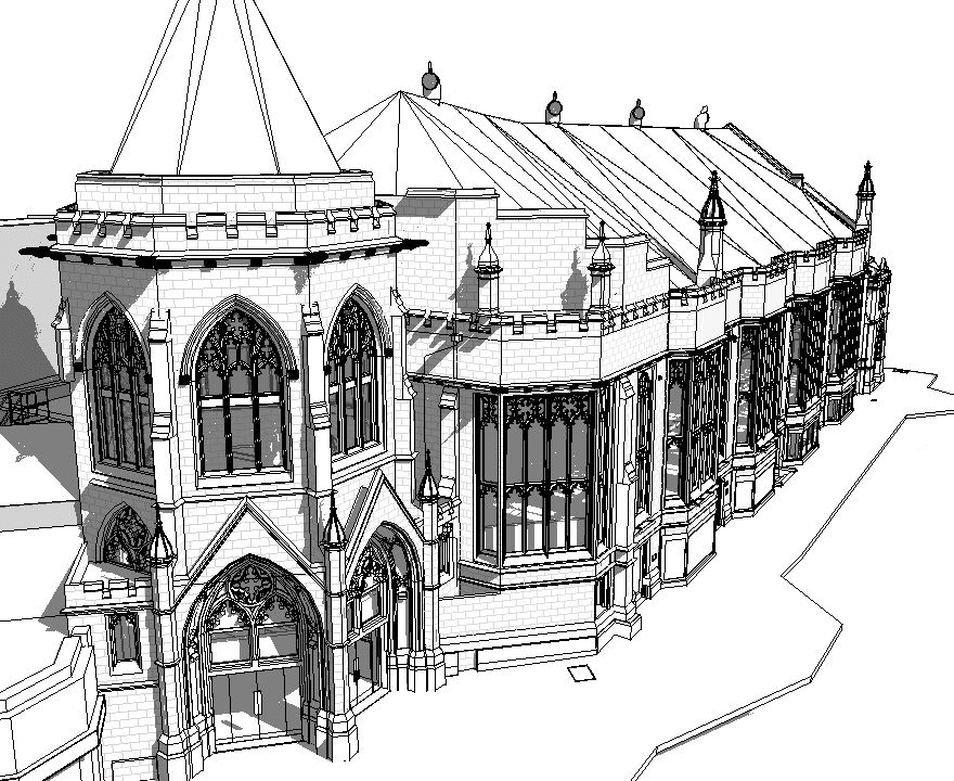
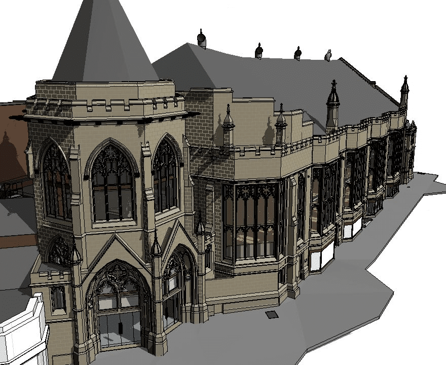
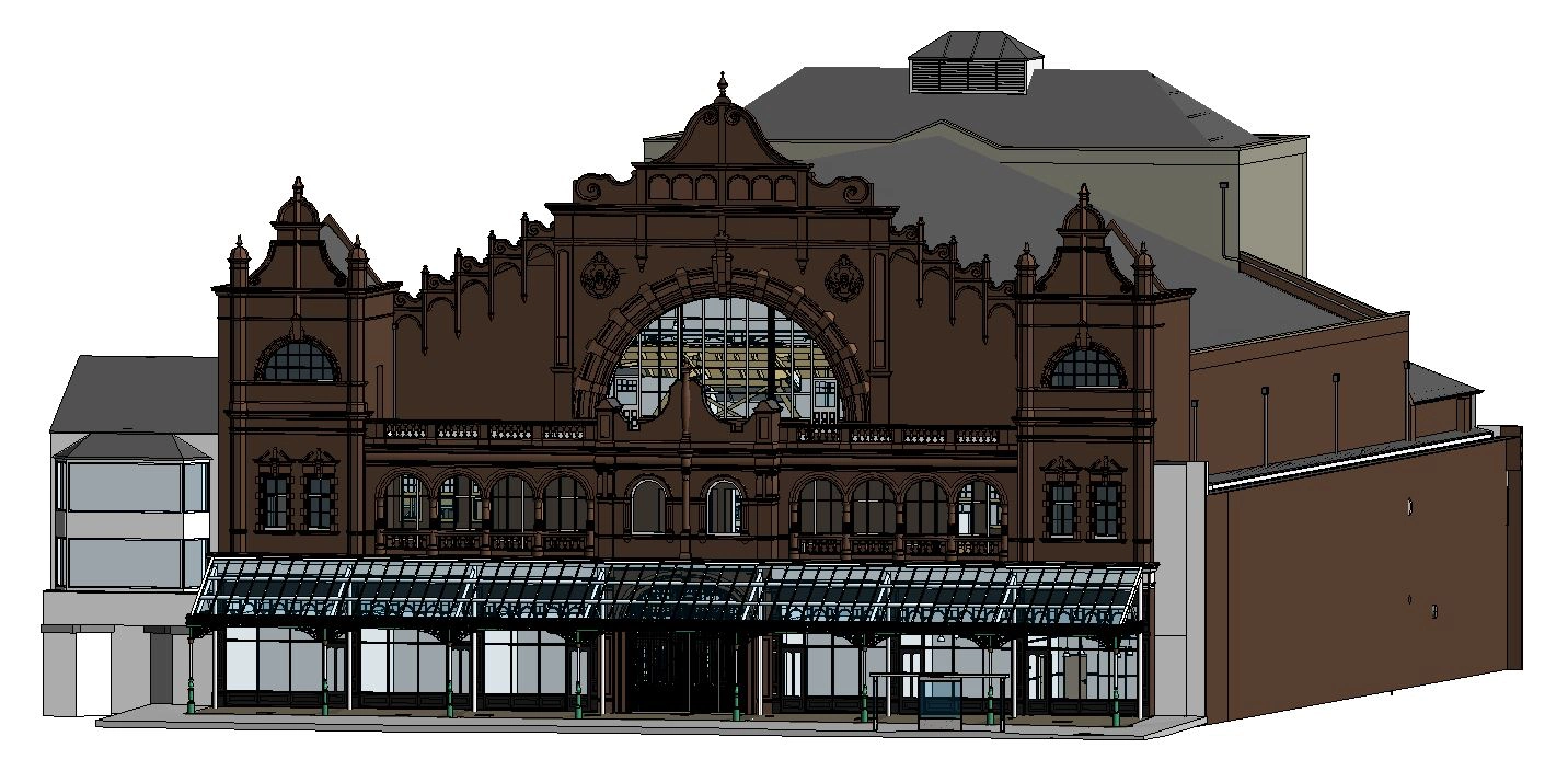
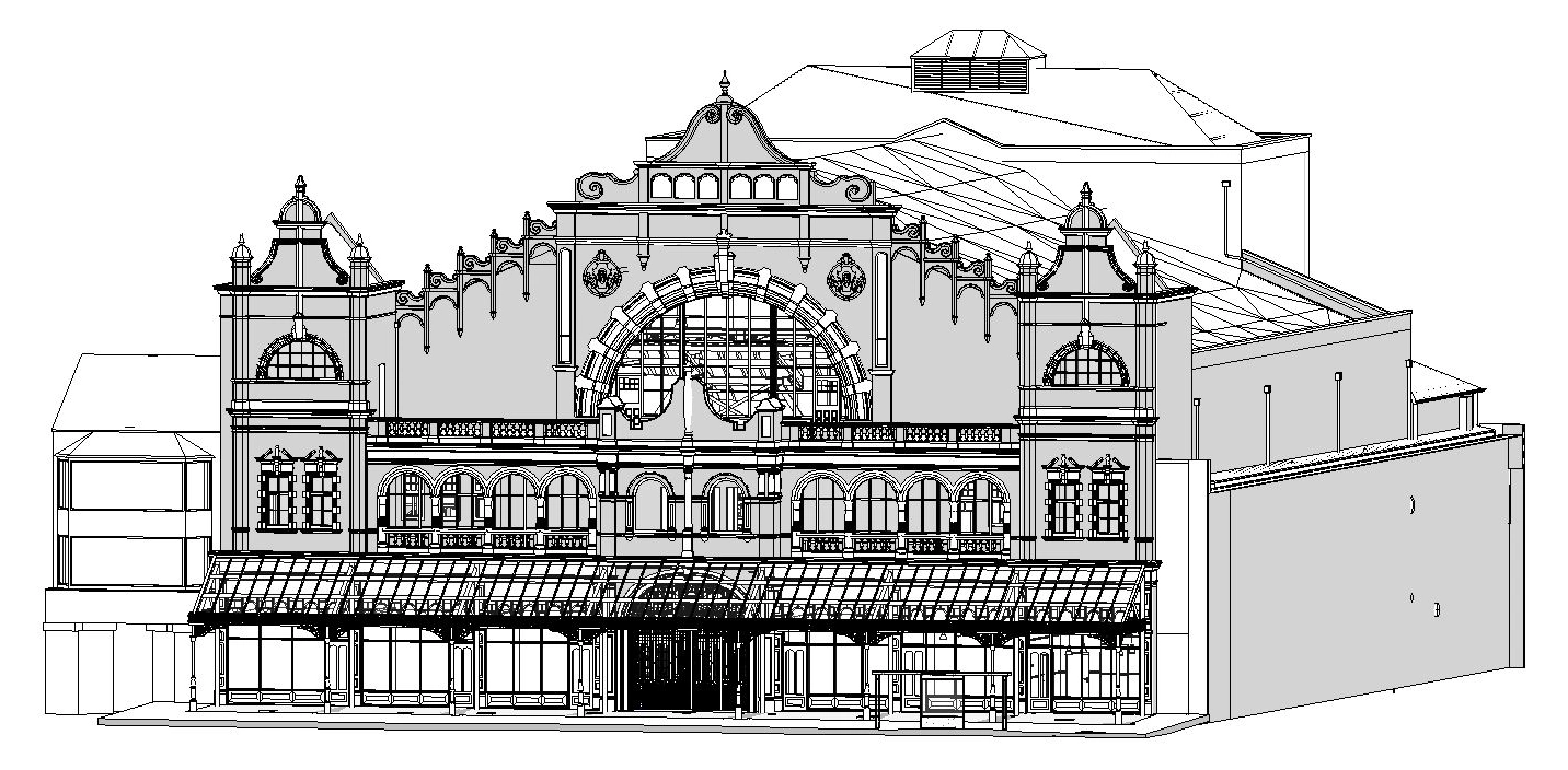
Darwen Library Theatre — Scan to BIM for Heritage Regeneration
BIM model creation for the Darwen Library Theatre — a significant heritage building in Darwen town centre that forms the centrepiece of the town’s regeneration programme. Our team produced a full Revit model from laser scan data, capturing the complex geometry of the theatre’s interior, the library building and the connecting spaces. The model gave the design team a complete, accurate digital record of the existing building — the basis for a sensitive and technically demanding regeneration scheme in the heart of Lancashire.
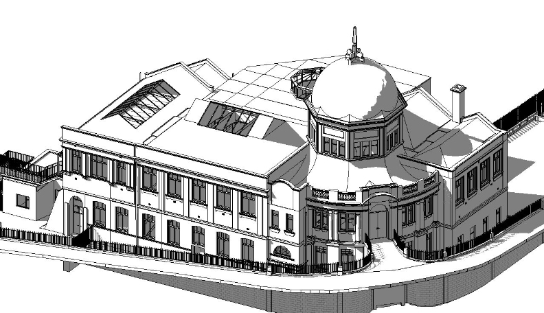
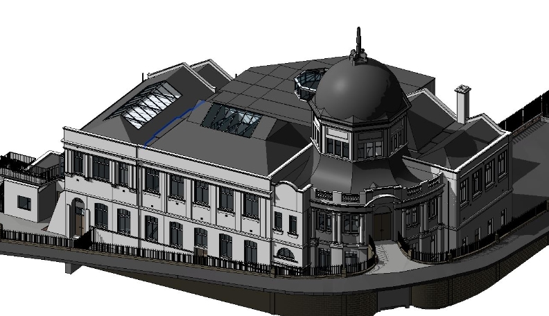
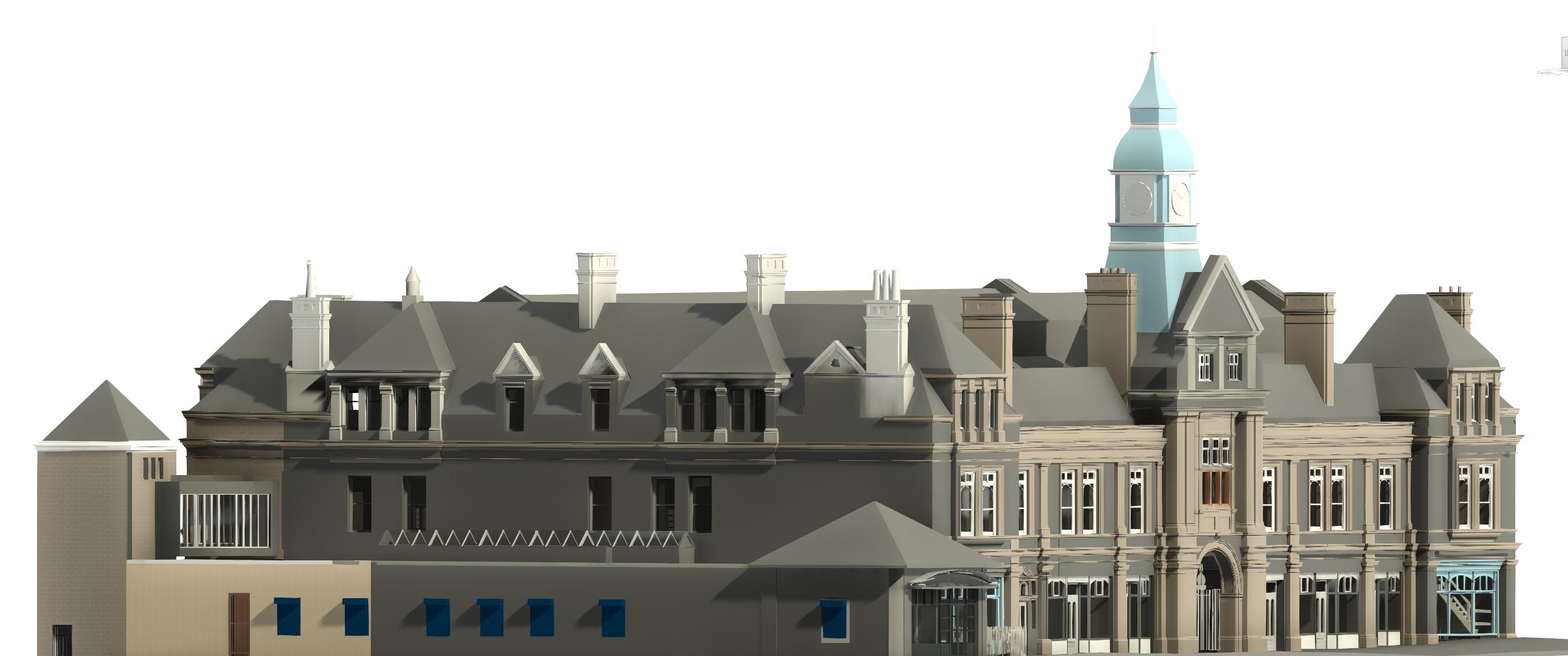
Morecambe Winter Gardens — Heritage BIM Survey
Scan to BIM survey of the Morecambe Winter Gardens — one of the most significant unrestored entertainment buildings in England and a Grade II listed structure of national heritage importance. Our team produced a Revit model of the building from laser scan data, capturing the ornate interior geometry, the complex structural fabric and the deteriorating building envelope that makes conventional survey methodologies impractical. The BIM model now supports the ongoing restoration programme and heritage planning process.
What scan to BIM means in practice
What scan to BIM means in practice
Scan to BIM is the process of converting laser scan data — the dense three-dimensional point cloud captured by our survey team on site — into a structured, intelligent BIM model that your design team can work from in Revit, AutoCAD or another BIM platform.
What your EIR needs to specify
The Employer’s Information Requirements document defines what the BIM model must contain, how it must be structured and in what format it must be delivered. A well-specified EIR at the start of the commission prevents misunderstanding and rework at delivery. When commissioning scan to BIM from Site Surveying Services, the following information in your EIR directly affects what we produce:
LOD
The level of detail required for each model element at each project stage.
Software platform and version
The Revit version, AutoCAD version or other platform your project team uses. We deliver in the version you specify.
Coordinate system and level datum
The shared coordinate system and benchmark level that will be used across all project disciplines. Agreed before survey and built into the scan registration.
Layer and naming conventions
The naming protocol for model elements, families and parameters. Following your convention from the outset eliminates the rework of renaming at coordination stage.
IFC export requirements
If IFC output is required alongside the native Revit file, the IFC schema and export settings should be agreed at the time of instruction.
Federated model requirements
If the model needs to federate with structural and MEP models from other consultants, the federation protocol and shared coordinate system need to be established before any modelling begins.
We review the EIR at the time of instruction and flag any requirements that are ambiguous or that will affect programme or cost. We do not discover EIR compliance issues at delivery.
The BIM creation process works as follows:
Site capture
Our survey team visits the site and scans the building or structure using high-precision 3D laser scanning equipment. Every surface, every opening, every structural element and every feature within the scanner's range is captured as a dense point cloud of measured data points.
Point cloud registration
Individual scan positions are registered together to produce a complete, seamless point cloud of the full building or site. Georeferenced to OS National Grid and tied to a site datum agreed with the project team.
BIM modelling
Our in-house BIM technicians work from the registered point cloud to produce the model in Revit or the platform your project requires. Walls, floors, ceilings, structural elements, openings, roof geometry, building services and all other elements are modelled to the LOD specified in your EIR.
Quality check and delivery
The completed model is checked against the point cloud by our team before delivery. Any discrepancies between the model and the scan data are identified and resolved before the model leaves our office. You receive a model you can work from immediately.
Structures
All above-ground structures including buildings, retaining walls, kerbs, steps, ramps and highway furniture.
Everything — scan, registration, modelling, QA and delivery — is completed in-house by Site Surveying Services. No third-party modelling firm. No outsourced processing. No gap between the people who captured the data and the people responsible for the model.
Who Commissions 3D BIM Modelling From us?
Who Commissions 3D BIM Modelling From us?
Architects and project managers
Scan to BIM for refurbishment, extension, change of use and new build projects at RIBA Stage 2 through to Stage 6. We produce models structured for immediate use in your design environment, at the LOD your project stage requires.
Heritage bodies and conservation architects
BIM models of listed and historic buildings for conservation planning, refurbishment design and heritage documentation. Our Darwen Library Theatre and Morecambe Winter Gardens models demonstrate what scan to BIM delivers on complex, significant heritage structures.
Local authorities and public sector estates
BIM models of civic buildings, schools, healthcare facilities and public infrastructure for estate management, refurbishment planning and capital programme development.
Industrial facility managers
As-built BIM models of process plant, industrial buildings and complex engineering environments for retrofit planning, maintenance coordination and regulatory compliance.
Construction contractors
As-built BIM verification at programme stages and coordination models for complex refurbishment and fit-out projects.
Facilities managers
LOD 500 asset models for lifecycle management, space planning and building management systems integration.
BIM Modelling for Your Sector
Understanding LOD — What Level Does Your Project Need?
Understanding LOD — What Level Does Your Project Need?
LOD — Level of Development, sometimes referred to as Level of Detail — defines how much geometric and information content the BIM model contains. Specifying the right LOD for your project stage is one of the most important decisions in commissioning a scan to BIM survey, because under-specifying wastes model value and over-specifying wastes budget and time. If you are not certain which LOD is appropriate for your project, tell us the design stage and how the model will be used downstream — we will advise. Getting the LOD right at the time of instruction prevents the most common and most expensive BIM survey problem: receiving a model at the wrong level of detail for the design stage it needs to serve. Your project can include a variety of LOD types, for example, choosing LOD 400 for internals and LOD 300 for externals.
LOD 100
Mass Model & Basic Site Surface
A outline mass modelling. Overall building volume and shape without detail like windows or door openings. Useful for early feasibility and massing studies but not for design coordination.
LOD 200
Basic Structural Model & Basic Site with Split Surfaces
Contains only major structural components and openings. Walls, floors, columns, beams and openings represented but not precisely dimensioned. Appropriate for concept design and planning applications where overall layout and relationships matter more than precise dimensions. Secondary structures, services, furnishings and architectural details are not included.
LOD 300
Standard Architectural Model, Services & Hard Surface Definition
A Level 3 model will additionally contain primary basic architectural details. Basic families can be created for doors and windows, but no surface finishes will be defined. Major services can be modelled in outline form, and fixed furnishings can be modelled in simplified form if requested. Primary structural components (columns, beams) modelled to define form such as steel RSJ, channel, angle, etc. Secondary structure is not included.
LOD 400
Detailed Architectural Model, Services & High Definition
A Level 4 model will additionally contain detailed architectural and structural elements. There can be a higher level of detail in families and fixed furnishings. Skirting, architraves, rails and cornices can be modelled. Significant surface finishes can be shown. If required, an investigative survey may be carried out above false ceilings. Secondary Structure included such as, cross/diagonal bracing, purlins, Steel stud framing, joists, rafters, ridge boards.
LOD 500
Detailed Services
The completed building as constructed, verified against the built reality. The asset record delivered at handover for facilities management and lifecycle use.
Our Services
How BIM Modelling Integrates With Other Services
How BIM Modelling Integrates With Other Services
Topographical Surveys
OS-controlled accurate, efficient and cost effective surveys for highways, civils and development. Cad and BIM-ready output.
PAS 128 utility mapping
Providing the location of underground services in 2D or 3D through qualified utility mapping surveys, using advanced GPR and Electromagnetic Location.
Measured building survey
Delivering accurate as-built information that supports design, refurbishment, planning and construction with the latest technology. Producing reliable drawings and digital models.
Laser Scanning
3D laser scanners capture millions of points per second, creating a point cloud which enables the finer details and the physical site to be viewed remotely.
Mobile mapping
For highway engineers, infrastructure managers, local authorities and contractors working on live road schemes, mobile mapping is now the standard for corridor surveys.
3D Machine control
With decades of supporting major earthworks contractors and large-scale infrastructure schemes, we provide reliable machine control across Lancashire and the wider UK.
Setting out engineers
With strong, long-standing relationships across the civil engineering and construction sector, we supply skilled professionals who keep your projects accurate, efficient and on programme.
bathymetric surveys & river surveys
Using modern technology, we capture detailed underwater and river channel information safely and efficiently – delivering reliable data you can trust.
Stockpile surveys & volumetric analysis
Whether a one-off stockpile measurement or regular monitoring, we deliver reliable, repeatable data tailored to your project using advanced technology.
Control Network Installation
Delivering robust and precise site control systems to support every stage of construction in developments, infrastructure schemes or major earthworks.
aerial & drone surveys
CAA-approved drone operations for aerial mapping, photogrammetry and volumetric analysis, providing a comprehensive view of terrain, structures and landscapes.
3D BIM Modelling
Whether you require an as-built Revit model, federated coordination model or detailed digital twin, our team delivers high quality, design-ready outputs.
survey equipment hire
We offer a vast range of surveying and engineering equipment for hire and will always try to beat a comparable quote. Discover the fleet.
monitoring
Providing reliable monitoring surveys across the UK, delivering precise data that supports risk management, compliance and informed decision making throughout a project lifecycle.
Virtual Tour 3D
An immersive experience which instantly transports your clients to your business, guiding them through your space and creating a seamless experience.
Impermeable area surveys
We deliver georeferenced impermeable area data that drainage engineers and planning consultants can work from directly.
CCTV & Drainage surveys
Acoustic & Noise Assessments
We deliver acoustic and noise assessments, supporting planning applications, discharge of conditions and Environmental Impact Assessments.
Why choose site surveying services
On site. On spec. On time.
The model built around your EIR.
We review the Employer's Information Requirements before scoping the survey. Not after delivering a model at the wrong LOD. The scope is confirmed before any capture begins.
In-house. Not outsourced.
Scan, registration, modelling, QA and delivery by our directly employed team. No gap between the people who captured the data and the people responsible for the model.
Checked against the scan.
Every model verified against the point cloud before delivery. You receive a model that accurately represents the building as surveyed — not one produced from assumptions.
Frequently Asked Questions
Frequently Asked Questions
What is scan to BIM?
Scan to BIM is the process of using laser scan data to create an accurate BIM model of an existing building or structure. The laser scan captures the existing physical conditions as a dense three-dimensional point cloud, which is then used as the base from which a structured, intelligent BIM model is produced in Revit or another BIM platform. Scan to BIM is the standard methodology for producing as-existing BIM models of buildings for refurbishment, extension, heritage recording and asset management.
What is the difference between a point cloud and a BIM model?
A point cloud is the raw output of a laser scan — millions of measured data points representing the geometry of the scanned space in three dimensions. A BIM model is a structured, intelligent digital model — walls, floors, columns, openings and other building elements — produced from the point cloud by a BIM technician. The point cloud contains all the geometric information; the BIM model organises that information into a format that design software can use for coordination, analysis and documentation. Both can be delivered as part of a scan to BIM commission.
What LOD do I need for my project?
LOD 200 for concept design and planning. LOD 300 for technical design coordination with structural and MEP consultants. LOD 400 for fabrication-level detail on complex or high-value projects. LOD 500 for the as-built record at handover. If you are not certain which LOD is appropriate, tell us what design stage the model needs to serve and what the downstream uses are — we will advise. Specifying the wrong LOD is the most common and most costly BIM survey mistake.
Do you deliver in Revit?
Yes. We produce Revit models in-house, in the version your practice uses. All modelling is completed by our directly employed BIM technicians — not outsourced. The model is checked against the point cloud before delivery. If your project requires IFC output, specific naming conventions or a particular shared coordinate system, confirm this at the time of instruction and we will build it into the deliverable specification.
What information do I need to provide in my EIR?
The key information that directly affects what we produce: the required LOD, the Revit version, the coordinate system and level datum, the layer and naming convention, any IFC export requirements and the federation protocol if the model needs to coordinate with structural and MEP models from other consultants. We review the EIR at instruction and flag anything that needs clarification before we begin. We do not discover EIR compliance issues at delivery.
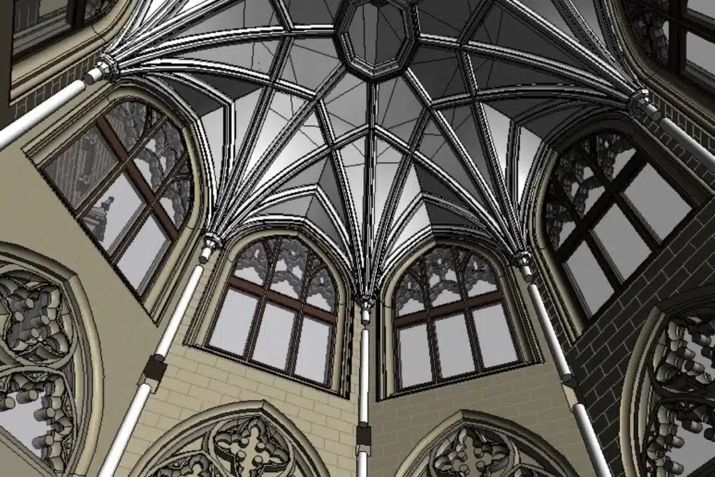
Can you produce BIM models of heritage and listed buildings?
Yes — and this is where scan to BIM delivers its greatest value. Heritage buildings are characterised by irregular geometry, complex historic fabric, non-standard room shapes and building elements that do not conform to the families and parameters designed for modern construction. Laser scanning captures all of this complexity as raw point cloud data; our BIM technicians model from the scan rather than imposing standard assumptions on non-standard buildings. Our Darwen Library Theatre and Morecambe Winter Gardens projects are direct demonstrations of heritage scan to BIM at significant scale and complexity.
What accuracy do your BIM models achieve?
BIM models produced from laser scan data are accurate to ±5–10mm for geometric elements, reflecting the accuracy of the underlying scan data. Where higher accuracy is required for specific elements — structural connections, critical interfaces, plant and equipment positions — we can increase the scan density and modelling specification for those elements. We confirm achievable accuracy for your specific building type and LOD at the time of scoping.
Can you combine BIM model creation with a topographic survey?
Yes — and on most projects that involve both a building and its surrounding site, we recommend it. Combining topographic survey with building scan and BIM model creation gives the design team ground levels, site context and complete building geometry in a single georeferenced dataset, all registered to the same datum. This is particularly important for extension and development projects where the relationship between the existing building and the proposed works must be accurately understood from the outset.
Do you offer CPD sessions on BIM and survey?
Yes. We offer free CPD sessions for architectural and design practices covering scan to BIM methodology, point cloud workflows, Revit model delivery and the practical integration of survey data into the design process. Our first session was delivered to Cassidy Ashton in Preston. Contact us to arrange a session for your practice.
What areas do you cover?
Our head office is in Clitheroe, Lancashire, with offices in Matlock, Newcastle and Bristol. We deliver scan to BIM services across the North West, North East, Midlands and South West as primary territories, and nationally. All work — scan capture, point cloud processing, BIM modelling and QA — is completed in-house by our directly employed team.