


Finishing off the week in style with our resident dancing surveyor, @_snipershotsurveyor. Although we take our surveying seriously, you might not find a better team than us!
We`ve got moves in and out of the survey world 😂 🌍
#trimblegeospatial #landsurveying #surveylife #topography #sitesurvey #geospatialdata #builtenvironment #construction
Proud to announce that we are official members of @asfccommunity Business Club committing to our Corporate Social Responsibilities & further contributing to our local community.
@sitesurveyingservices
@tritechsurveys
#businessclub #community #csr #accringtonstanley #lancashire #communitytrust
If you`re praying for a survey as good as this one, why not have some faith and call @sitesurveyingservices 🙏 🤣
Excuse the puns, it`s Friday afternoon and we`re all looking forward to the weekend after another flat out week for the team on all fronts.
@sitesurveyingservices
@tritechsurveys
@trimblegeospatial
@korecgroup
#trimblegeospatial #x7 #laserscanning #measuredbuildingsurvey #elevations #floorplans #geospatialdata #builtenvironment #construction #architecturaldesign
WE`RE EXHIBITING!!
We are delighted to announce that we are attending The Lancashire Business Expo 2024 - @shoutexpo
Come down to see us at the Sir Tom Finney Sports Centre on Friday 22nd March from 09:00am until 17:00!
@sitesurveyingservices
@tritechsurveys
@shoutconnecthq
@so.network
#exhibiting #expo #shout #shoutnetwork #virtualtour #virtualwalkthroughs #matterport3d #matterport #3dtour
Is that George Clooney and Leonardo Di Caprio?
Unfortunately not, it`s National Apprentice week and we thought we`d celebrate our very own apprentices!
@_owe_n1 joined us back in July 2021 and was our very first apprentice. We enrolled him on the very first Geospatial Technician course at Cronton Sixth Form College and he passed with flying colours. Owen is now confidently carrying out his own Topographical and Measured Building Surveys along with the odd bit of setting out.
@_snipershotsurveyor joined us in March last year after a couple of weeks work experience to get a taste of the world of the built environment and see if it was for him. This came on the back of being let down by other trades and being guided our way by Alison Watson MBE. Alfie is well underway with his first year at Cronton college and is making great progress. He is currently carrying out Topo with guidance from Senior staff members and particularly enjoys getting stuck in on setting out & utility jobs.
We would encourage others to take a chance on taking on an apprentice. They are hard working and eager to learn. With the right training, sometimes patience and expertise, they can be molded in to becoming the next line of Geospatial Superstars!
@sitesurveyingservices
@tritechsurveys
@surveyassoc
#nationalapprenticeshipweek #apprenticeships #education #geospatialdata #surveylife #surveying #builtenvironment #construction
Is it a Trimble X7 or the famous WWE wrestler, The Undertake?
Rising from the smoke is infact our Trimble X7! Laser scanning and producing a point cloud for this Chemical plant down in Cheshire.
@sitesurveyingservices
@tritechsurveys
@trimblegeospatial
#laserscanning #pointcloud #surveying #surveylife #trimblegeospatial #3dscanning #trimble #x7 #builtenvironment #geospatialdata #survey #construction
I spent this morning carrying out a Virtual Tour for our friends at @eastlancshospice
The hospice is a genuinely nice place to be, and as they are so passionately plea it is not just a place to die!
They have absolutely tons going on and hopefully with our assistance, we can help get that message out to the masses to help get them some more support!
If you would like to Showcase your Space, please get in touch today - hello@virtualtour3d.co.uk
@sitesurveyingservices
@tritechsurveys
#virtualtours #3dwalkthrough #marketing hashtag#advertising #charitysupport #surveylife
We absolutely love a challenge. There`s nothing better as surveyors!
For the last few days we`ve been fighting against the River Hornby 🌊 and it`s ever changing speeds to carry out a topographical survey.
We also used our Trimble X7 to scan the structure itself to produce detailed elevations to assist with the repair of this bridge.
What a way to end the week!
@sitesurveyingservices
@tritechsurveys
@trimblegeospatial
#trimblegeospatial #surveylife #laserscanning #riversurvey #trimble #survey #topography #landsurvey #elevations #builtenvironment #construction
Give over horsing around and get on with the survey 🐴
Always love a good survey on a farm meeting all the furry inhabitants!
@sitesurveyingservices
@tritechsurveys
@leica_geosystems
#surveylife #surveying #topography #topo #leicageosystems #leica #survey #builtenvironment #construction #surveyworld #geospatial #geospatialdata #landsurvey #lancashire
And just like that we`re basically in February. A busy month across the county and up & down the country from Barrow to Bromley.
We still have availability in February, so if you have a surveying project that you require our expertise with get in touch today!
E: admin@sitesurvey.co.uk
T: 01200 438320
W: www.sitesurvey.co.uk
Have a good weekend!
@sitesurveyingservices
@tritechsurveys
#topography #settingout #measuredbuildingsurvey #floorplans #elevations #uavmapping #riversurvey #surveylife #leicageosystems
Halal, is it meat you`re looking for?
Measured building survey ticked off to start the week ✅
@sitesurveyingservices
@tritechsurveys
@trimblegeospatial
#laserscanning #pointcloud #floorplans #elevations #builtenvironment #construction #trimble #x7 #geospatial #surveylife #survey #sitesurvey
#throwbackthursday carrying out a UAV Survey of Blackburn Museum on behalf of our client.
Using this method of surveying complimented the laser scanning we had already carried out using traditional scanners. It prevented us from accessing the roof and captured all the detail we needed!
@sitesurveyingservices
@tritechsurveys
#uavmapping #pointcloud #surveylife #drone #laserscanning #measuredbuildingsruvey #builtenvironment #construction #restoration #floorplans #elevations #survey #surveying
Setting out engineers are responsible for determining the precise location and orientation of the various components of a construction project, such as the foundations, walls, and other structural elements. This involves using surveying and mapping tools to establish the exact position of these elements, and to ensure that they are in the correct position and orientation when construction begins.
Here we are Setting out grid lines and external brickwork corners on one of our sites over in Harrogate today.
@sitesurveyingservices
@tritechsurveys
@leica_geosystems
#leicageosystems #settingout #siteengineering #builtenvironment #construction #surveylife #sitesurvey
Topping off a very, very busy week at Site Surveying Services Ltd - We`ve been nominated for a Ribble Valley Business Award. Starting 2024 how we mean to go on.
More projects over the line and new clients secured. Another flat out week next week to keep the ball rolling. Enjoy the weekend everyone!
@sitesurveyingservices
@tritechsurveys
#sitesurveying #construction #builtenvironment #awardnomination #surveylife #ribblevalley
Christmas is over and we`re open & all back on site this week!
We`re up & down and all over the country. Now it may be a strange coincidence, but most of our sites are based in places beginning with the letter B - Blackburn, Bradford, Bromley, Bristol and Barnoldswick 😂 🤔
#leicageosystems #topography #landsurveying #measuredbuildingsurvey #floorplans #elevations #settingout #utilitymapping #uavmapping
As our annual Christmas shutdown approaches, we want to take a moment to express our deepest gratitude for the privilege of working with all our clients throughout the year.
The spirit of Christmas reminds us to appreciate the connections we`ve made and the successes we`ve shared.
In the spirit of joy and togetherness, we extend our warmest wishes to you and your loved ones. May this festive season be filled with laughter, love, and unforgettable moments. May you find time to cherish the simple pleasures, create lasting memories, and embrace the magic that surrounds us.
It has been a pleasure collaborating with you, and we look forward to continued success and partnership in the coming year. Your support has been invaluable, and we are grateful for the trust you have placed in us.
As we bid farewell to this year and welcome a new one, may it bring prosperity, good health, and boundless opportunities.
Thank you for being an integral part of our journey.
Merry Christmas and a Happy New Year from the team at @sitesurveyingservices!
#surveylife #leicageosystems #topography #siteengineering #settingout #measuredbuildingsurvey #laserscanning #uavmapping #riversurvey #builtenvironment #construction #surveying #christmas #newyear2024
We`re running an in house social media competition this month to see who can come up with the best short clip featuring some classic 70/80s music!
Here is @fostman_j latest entry! There are some good ones submitted so far, we`ll be posting some more of the best this week!
@sitesurveyingservices
@tritechsurveys
@leica_geosystems
WE DO NOT OWN THE RIGHTS TO THIS MUSIC.
#surveylife #surveying #socialmediacompetition #competition #employeeengagement #incentive #topography #topo #leica #leicagoesystems
A nice festive treat from @pagewood_bakery! Thanks to Helen for sorting out a last minute order for some of our clients and if you need anything bake associated, be sure to get in touch with her!
Good job we`ve not got a full office today because these aren`t going to be around for long!!
@sitesurveyingservices
@tritechsurveys
#surveylife #brownies #pagewoodbakery #customerservice #surveying #christmas #2023
Continuing our site work at in Blackburn trying to avoid the thieves that are out and about in the area.
One attempted robbery won`t stop us! Surveying well up to Christmas 🎄
@sitesurveyingservices
@tritechsurveys
#sitesurveying #leicageosystems #surveying #surveylife #topo #topography #ts16 #landsurvey #builtenvironment #geospatial
We seem to be getting a bit of a reputation for surveying reservoirs at the moment! It seems to be one every other week, but nothing our apprentice @_snipershotsurveyor can`t manage.
@sitesurveyingservices
@tritechsurveys
@leica_geosystems
@surveyassoc
#topography #topo #surveying #surveylife #sitesurvey #sitesurveying #landsurvey #reservoir #leica #leicageosystems #apprentice #training #learningonthejob #lancashire #builtenvironment #construction #ts16
We promised some exciting news on the Virtual Tour front in December and here she is....
We have a brand new Virtual Tour Co-ordinator - Pippa!
Pippa joins the team with a keen eye for sales and a background in business development. She`s taken to the role like a duck to water, the only downfall is her Leeds accent 😂
Keep an eye out for our latest Virtual Tour at @sthanm1 which will be coming very soon!!!
@sitesurveyingservices
@tritechsurveys
#virtualtour3d #virtualtours #virtualtour #virtualwalkthrough #3dtour #walkthrough #sthanm1 #manchester #citycentre
A crisp and mightily cold start to the day out in Bury. The start of a few days topo on this site including the drainage!
Nothing like -3.5 degrees to make you work faster 😂❄⛄
@sitesurveyingservices
@tritechsurveys
@trimblegeospatial
#topography #trimblegeospatial #winter #surveying #cold #lancashire #surveylife #trimble #geospatial #geospatialdata #builtenvironment #construction #topo #survey
Too early to get into the Christmas spirit?
Mikey certainly doesn`t think so!! Have a good weekend everyone!
Thanks for the freebies @creativebranding1!
@sitesurveyingservices
@tritechsurveys
#surveying #surveylife #creativebranding #workwear #christmas #xmas #santa #surveysanta #topography #measuredbuildingsurvey #siteengineering
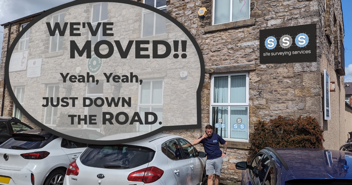
It`s taken 4 months, but we`ve finally got the new signs up at our new office! You can even see the logo for our new `side hustle` - Virtual Tours 3D 👀
We`ve got some exciting news about Virtual Tours 3D, which will be announced early next month!
First time we`ve been properly sign posted in 26 years 😂
@sitesurveyingservices
@tritechsurveys
#sitesurvey #surveylife #surveying #topography #siteengineering #measuredbuildingsurvey #laserscanning #uavmapping #utilitymapping #virtualtours #virtualreality #walkthrough
A selection of photos from the sites we`ve been working on this week! From scanning existing steel frames at Oldham Library, Virtual Touring at a nursery, to carrying out km`s of Topographical Survey throughout Lancashire!
@sitesurveyingservices
@tritechsurveys
@leicageosystems
@trimblegeospatial
#landsurveying #laserscanning #rtc360 #rtc #pointcloud #steelstructure #steelfabrication #structuralengineering #topography #trimble #trimblegeospatial #totalstation #surveying #survey #surveylife #builtenvironment #construction
It doesn`t look like it, but about 5 minutes after this photo was taken Storm Debi took full affect and blew our Michael down in to that well. If anyone wants to save him, he`s in Blackpool 😂
It`s been a tough ask getting any site work done today, but we`ve managed to crack on nonetheless. Weather really is the enemy this time of year!
@sitesurveyingservices
@tritechsurveys
#leicageosystems #trimblegeospatial #topography #landsurvey #measuredbuildingsurvey #pointcloud #laserscanning #surveylife #builtenvironment #construction
When @_snipershotsurveyor catches you `doing it for the gram` 😂 you`re in trouble!
Happy Friday everyone!!!
@sitesurveyingservices
@tritechsurveys
#landsurvey #landsurveying #doingitforthegram #instagram #photoshop #surveying #surveylife #surveyor #survey #topography #topo #blackburn #lancashire #builtenvironment #construction #activetravel #friday #fridayfeeling
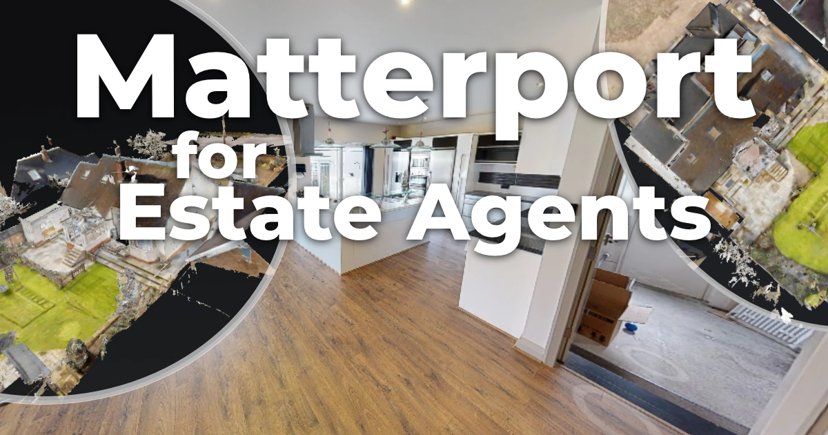
The latest of our Virtual Tours over at the Glusburn Institute. Producing an immersive virtual experience for their potential new clients and customers alike.
This cutting-edge technology shows the innovative concept of a digital twin which provides an authentic, interactive 3D replica of a physical space.
Offer your clients an authentic encounter with a 3D walkthrough, enabling them to fully immerse themselves in your venue beyond mere photographs and standard 360 tours. This groundbreaking approach distinguishes your business, propelling it to a prominent position within the competitive arena.
Whether you are in the retail, commercial, real estate or construction sector, our surveys offer a cutting-edge solution that will elevate your projects to new heights.
For enquiries, please get in touch - admin@sitesurvey.co.uk or 01200 438320
@sitesurveyingservices
@tritechsurveys
#virtualtour3d #virtualtour #virtualwalkthrough #3dtour #virtualreality #VR #3d #surveying #surveylife #matterport #matterport3d #construction #rovers #builtenvironment #surveying
Somewhere behind this blanket of fog, believe it or not, is a reservoir 😂😂
A gloomy and wet start to the week, but there`s not much that can put a stop to our surveys!
@sitesurveyingservices
@tritechsurveys
#topo #topography #leica #leicageosystems #surveying #surveylife #survey #ts16 #surveyor #landsurvey #construction #asbuilt #builtenvironment #3D #reservoir #lancashire
It’s the scariest and spookiest day of the year, so here’s a throwback of a scary clip we experienced on site a few years ago!
@sitesurveyingservices
@tritechsurveys
@leica_geosystems
#halloween #surveylife #leica #p40 #scaryseason #surveying #pointcloud #scantobim #leicageosystems #laserscanning
We`ve been awarded a large series of road surveys, so we felt it was necessary to kit out a couple of the lads that are going to be undertaking the survey 😂
They`re sick of being asked not to take any photos or if they`ve just caught them speeding. We thought it might save some time 😂
Thanks to our friends at @creativebranding1 for sorting this out for us. They always go above and beyond to make sure we get what we want 😊
@sitesurveyingservices
@tritechsurveys
#topography #roadsurveys #settingout #siteengineering #topo #survey #surveylife #road #levellingup #cycleroutes #cycling #activetravel #active #leicageosystems
Who said that Business Networking has to be boring?
A great morning spent over at the lovely @dunscargolfclub at the @shoutconnecthq meeting.
Lots of great chats and looking forward to some 1 to 1s in the not to distant future!
@sitesurveyingservices
@tritechsurveys
#networking #b2b #connections #business #businessgrowth #newcontacts #referral #shout #shoutnetwork #bolton #dunscar #surveying #surveylife #virtualtours #construction #builtenvironment #architecture
A moody Monday morning to start the week off. This morning @_snipershotsurveyor is out at St Simon`s School in Bolton.
Another busy week scheduled for the team. Looking forward to getting our heads down and cracking on!
@sitesurveyingservices
@tritechsurveys
#sitesurveying #surveying #settingout #siteengineering #construction #asbuilt #concrete #installation #newproject #building #setout #settingoutengineer #trimble #trimblegeospatial #survey #greatermanchester
The full squad is finishing the week off by getting safely out the way of Storm Babet and into our warm office with a full english breakfast on the house!
From setting out bolt boxes to surveying the local roads, we`ve covered a lot of ground this week. Next on the agenda, we begin a road survey that could see us into the new year and a laser scanning project down in Cornwall.
@sitesurveyingservices
@tritechsurveys
#surveying #surveylife #topo #topography #settingout #construction #builtenvironment #fridayfeeling #sitesurveying
We did it or should I say @hainsey_28 did it!
We`re now part of the @charteredices Approved Development Scheme for Geospatial Engineering 💪
@sitesurveyingservices
@tritechsurveys
#cices #geospatialengineering #geospatial #surveying #approved #development #construction #training #chartered #engineering #surveylife #survey
Taking an AS Built survey of this housing development down the road in Blackburn.
A project we`ve assisted with the Site Engineering on, it`s great to see it coming along nicely!
@sitesurveyingservices
@tritechsurveys
@leicageosystems
#leica #leicageosystems #settingout #settingoutengineer #engineering #siteengineer #construction #asbuilt #builtenvironment #housebuilding #survey #surveylife #blackburn #lancashire #friday #fridayvibes
A moody shot from across the Leisure Lakes in Southport.
Moody is probably how best to describe our surveyor that was on site after the dredged rain soaked him through today 😂
@sitesurveyingservices
@tritechsurveys
@leica_geosystems
#leicageosystems #topography #topo #landsurveying #lancashire #ts16 #survey #surveylife #surveying #southport #leisurelakes #fourseasons #glamping #virtualtour
A really interesting and quite tricky topographical survey out in Southport today. Lots of intricate details and tricky setups!
It will be worth it when it`s all drawn up, almost art like, some might say it will be a quacking survey!
@sitesurveyingservices
@tritechsurveys
@leicageosystems
#leicageosystems #totalstation #ts16 #topography #survey #surveylife #surveying #construction #planning #builtenvironment #topo #southport #lancashire